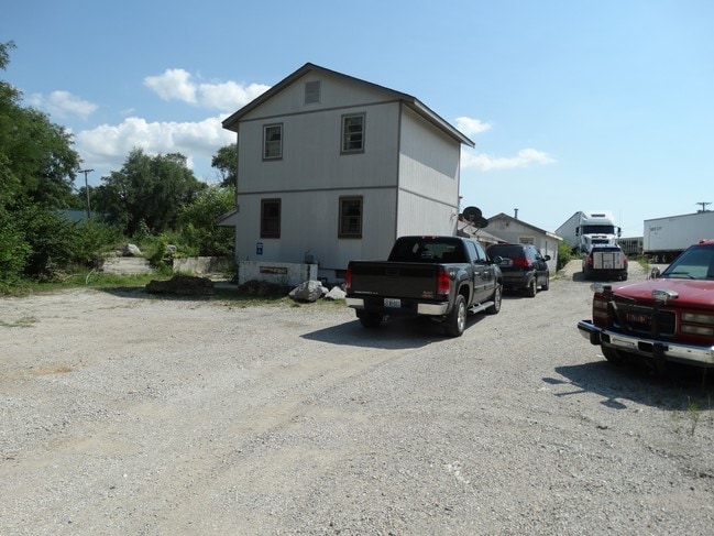
Property Record
519 Blue Ridge Ext, Grandview, MO 64030


NEARBY LISTINGS FOR SALE OR LEASE
Property Detail
519 Blue Ridge Ext
Kansas City, MO-KS
Grandview Heights Resurvey
64-820-06-01-01-0-00-000
GRANDVIEW HEIGHTS RESURVEY---PT LOTS 13-17 DAF: BEG SW COR N W 1/4 SEC 14 TWP-47 RNG 33 TH N 89 SEG 45 MIN 33 SEC E 1333. 98 TH N 04 DEG 12 MIN 17 SEC E 25.08 TO POB TH N 04 DEG 12
Industrialgeneral
Jackson
X
Missouri
29095C0395G
13-17
0
4.38 AC
2025
Grandview
013301
Kansas City
DEMOGRAPHICS near 519 Blue Ridge Ext
1 Mile
3 Mile
5 Mile
2024 Total Population
5,989
47,058
106,813
2029 Population
6,005
46,864
107,682
Pop Growth 2024-2029
+ 0.27%
(0.41%)
+ 0.81%
Average Age
39
38
39
2024 Total Households
2,602
18,950
44,316
HH Growth 2024-2029
0.00%
(0.54%)
+ 0.72%
Median Household Inc
$41,058
$54,843
$60,860
Avg Household Size
2.20
2.40
2.30
2024 Avg HH Vehicles
2.00
2.00
2.00
Median Home Value
$157,848
$158,411
$198,276
Median Year Built
1971
1970
1974
Nearby Places
Map Layers
Map Styles
 Street
 Aerial
- Restaurants
- Banks
- Shops
- Fitness
- Groceries
PUBLIC TRANSPORTATION
AIRPORT
Kansas City International
DRIVE
WALK
Distance
Kansas City International
51 min
35.9 mi
SALE & LEASE HISTORY
LISTING DATE
SALE/LEASE

Oct 07, 2016
For Sale
Nov 22, 2016
For Sale
Nearby Properties
Address
Land Use
TOTAL SIZE
Lot Size
Zoning
Address
Land Use
TOTAL SIZE
Lot Size
Zoning
1,314,506 SF
174 AC
Address
Land Use
TOTAL SIZE
Lot Size
Zoning
915,528 SF
72.47 AC
Address
Land Use
TOTAL SIZE
Lot Size
Zoning
319,892 SF
Address
Land Use
TOTAL SIZE
Lot Size
Zoning
447,462 SF
37.91 AC
Address
Land Use
TOTAL SIZE
Lot Size
Zoning
227,676 SF
15.86 AC
Address
Land Use
TOTAL SIZE
Lot Size
Zoning
425,779 SF
23.23 AC
Address
Land Use
TOTAL SIZE
Lot Size
Zoning
270,862 SF
27.39 AC
Address
Land Use
TOTAL SIZE
Lot Size
Zoning
355,091 SF
41.50 AC
Address
Land Use
TOTAL SIZE
Lot Size
Zoning
504,100 SF
39.25 AC
Address
Land Use
TOTAL SIZE
Lot Size
Zoning
628,134 SF
37.62 AC
Address
Land Use
TOTAL SIZE
Lot Size
Zoning
180,271 SF
21.60 AC
Address
Land Use
TOTAL SIZE
Lot Size
Zoning
35,850 SF
41.30 AC
Address
Land Use
TOTAL SIZE
Lot Size
Zoning
303,625 SF
Address
Land Use
TOTAL SIZE
Lot Size
Zoning
94,080 SF
5.83 AC
Address
Land Use
TOTAL SIZE
Lot Size
Zoning
80,976 SF
1.82 AC
Address
Land Use
TOTAL SIZE
Lot Size
Zoning
315,314 SF
37.40 AC
Address
Land Use
TOTAL SIZE
Lot Size
Zoning
46,317 SF
9.63 AC
Address
Land Use
TOTAL SIZE
Lot Size
Zoning
253,575 SF
43.62 AC
Address
Land Use
TOTAL SIZE
Lot Size
Zoning
15,528 SF
2.50 AC
Address
Land Use
TOTAL SIZE
Lot Size
Zoning
485,993 SF
22.35 AC
Address
Land Use
TOTAL SIZE
Lot Size
Zoning
166,384 SF
27.90 AC
Address
Land Use
TOTAL SIZE
Lot Size
Zoning
94,123 SF
37.36 AC
Address
Land Use
TOTAL SIZE
Lot Size
Zoning
23,257 SF
11.04 AC
Address
Land Use
TOTAL SIZE
Lot Size
Zoning
13,088 SF
25.27 AC
Address
Land Use
TOTAL SIZE
Lot Size
Zoning
23,164 SF
23.60 AC
Address
Land Use
TOTAL SIZE
Lot Size
Zoning
400,392 SF
20.01 AC
Address
Land Use
TOTAL SIZE
Lot Size
Zoning
587,871 SF
57.57 AC
Address
Land Use
TOTAL SIZE
Lot Size
Zoning
84,968 SF
9.51 AC
Address
Land Use
TOTAL SIZE
Lot Size
Zoning
62,771 SF
0.14 AC
Address
Land Use
TOTAL SIZE
Lot Size
Zoning
128,111 SF
0.32 AC
The World's #1 Commercial Real Estate Marketplace
Connect with us
© 2026 CoStar Group
The information above has been obtained from sources believed reliable. While we do not doubt its accuracy we have not verified it and make no guarantee, warranty or representation about it. It is your responsibility to independently confirm its accuracy and completeness. Any projections, opinions, assumptions, or estimates used are for example only and do not represent the current or future performance of the property. The value of this transaction to you depends on tax and other factors which should be evaluated by your tax, financial, and legal advisors. You and your advisors should conduct a careful, independent investigation of the property to determine to your satisfaction the suitability of the property for your needs.