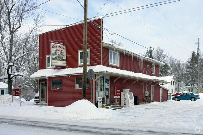
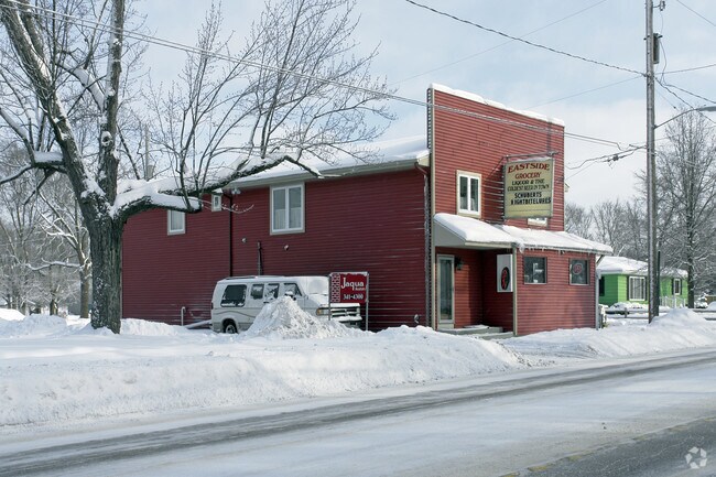
Property Record
519 E Bridge St, Plainwell, MI 49080
NEARBY LISTINGS FOR SALE OR LEASE
-
-
View all Plainwell listings for sale on LoopNet.com
Property Detail
519 E Bridge St
Holland, MI
Railroad Add
55-270-004-00
LOT 4 BLOCK 1 RAILROAD ADDITION TAX MAP: 0.12 AC
Commercialnec
Allegan
X
Michigan
26005C0609G
4
2024
3.12 AC
2025
Outlying Allegan County
032100
West Michigan
2,682 SF
DEMOGRAPHICS near 519 E Bridge St
1 mile
3 mile
5 mile
2024 Total Population
3,578
11,357
21,233
2029 Population
3,592
11,441
21,355
Pop Growth 2024-2029
+ 0.39%
+ 0.74%
+ 0.57%
Average Age
41
41
41
2024 Total Households
1,401
4,425
8,305
HH Growth 2024-2029
+ 0.21%
+ 0.63%
+ 0.45%
Median Household Inc
$72,279
$75,813
$74,876
Avg Household Size
2.40
2.50
2.50
2024 Avg HH Vehicles
2.00
2.00
2.00
Median Home Value
$169,185
$173,748
$182,617
Median Year Built
1963
1976
1975
Nearby Places
Map Layers
Map Styles
 Street
 Aerial
Transit
 Traffic
 Biking
Places
Listings with unknown addresses are not visible on the map
- Restaurants
- Banks
- Shops
- Fitness
- Groceries
PUBLIC TRANSPORTATION
AIRPORT
Kalamazoo/Battle Creek International
Drive
Walk
Distance
Kalamazoo/Battle Creek International
31 min
22.3 mi
Freight Ports
Port Milwaukee
Drive
Walk
Distance
Port Milwaukee
282 min
241.7 mi
Nearby Properties
Address
Land Use
TOTAL SIZE
Lot Size
Zoning
Address
Land Use
TOTAL SIZE
Lot Size
Zoning
209,000 SF
29.66 AC
Address
Land Use
TOTAL SIZE
Lot Size
Zoning
189,919 SF
Address
Land Use
TOTAL SIZE
Lot Size
Zoning
164,105 SF
18.53 AC
Address
Land Use
TOTAL SIZE
Lot Size
Zoning
71,337 SF
7.04 AC
Address
Land Use
TOTAL SIZE
Lot Size
Zoning
53,661 SF
6.30 AC
Address
Land Use
TOTAL SIZE
Lot Size
Zoning
214,356 SF
23.34 AC
Address
Land Use
TOTAL SIZE
Lot Size
Zoning
48,898 SF
5.30 AC
Address
Land Use
TOTAL SIZE
Lot Size
Zoning
40,081 SF
3.92 AC
Address
Land Use
TOTAL SIZE
Lot Size
Zoning
18,388 SF
8.85 AC
R-2
Address
Land Use
TOTAL SIZE
Lot Size
Zoning
95,484 SF
8.83 AC
Address
Land Use
TOTAL SIZE
Lot Size
Zoning
76,142 SF
43.96 AC
R1
Address
Land Use
TOTAL SIZE
Lot Size
Zoning
345,769 SF
33 AC
Address
Land Use
TOTAL SIZE
Lot Size
Zoning
33,665 SF
2.40 AC
Address
Land Use
TOTAL SIZE
Lot Size
Zoning
35,555 SF
1.10 AC
Address
Land Use
TOTAL SIZE
Lot Size
Zoning
21,047 SF
4.74 AC
Address
Land Use
TOTAL SIZE
Lot Size
Zoning
16,886 SF
1.86 AC
Address
Land Use
TOTAL SIZE
Lot Size
Zoning
39,656 SF
5.56 AC
Address
Land Use
TOTAL SIZE
Lot Size
Zoning
155,146 SF
6.31 AC
Address
Land Use
TOTAL SIZE
Lot Size
Zoning
30,220 SF
7.28 AC
Address
Land Use
TOTAL SIZE
Lot Size
Zoning
34,801 SF
0.92 AC
Address
Land Use
TOTAL SIZE
Lot Size
Zoning
41,362 SF
0.92 AC
Address
Land Use
TOTAL SIZE
Lot Size
Zoning
51,300 SF
1.84 AC
Address
Land Use
TOTAL SIZE
Lot Size
Zoning
1,000 SF
1.40 AC
R-2
Address
Land Use
TOTAL SIZE
Lot Size
Zoning
86,907 SF
3.44 AC
Address
Land Use
TOTAL SIZE
Lot Size
Zoning
115,108 SF
5.17 AC
Address
Land Use
TOTAL SIZE
Lot Size
Zoning
28,160 SF
4.38 AC
Address
Land Use
TOTAL SIZE
Lot Size
Zoning
2,606 SF
236.70 AC
AG
Address
Land Use
TOTAL SIZE
Lot Size
Zoning
30,960 SF
5.04 AC
Address
Land Use
TOTAL SIZE
Lot Size
Zoning
63,916 SF
2.89 AC
Address
Land Use
TOTAL SIZE
Lot Size
Zoning
1,119 SF
26.41 AC
RMH
The World's #1 Commercial Real Estate Marketplace
Connect with us
© 2026 CoStar Group
The information above has been obtained from sources believed reliable. While we do not doubt its accuracy we have not verified it and make no guarantee, warranty or representation about it. It is your responsibility to independently confirm its accuracy and completeness. Any projections, opinions, assumptions, or estimates used are for example only and do not represent the current or future performance of the property. The value of this transaction to you depends on tax and other factors which should be evaluated by your tax, financial, and legal advisors. You and your advisors should conduct a careful, independent investigation of the property to determine to your satisfaction the suitability of the property for your needs.