Property Record
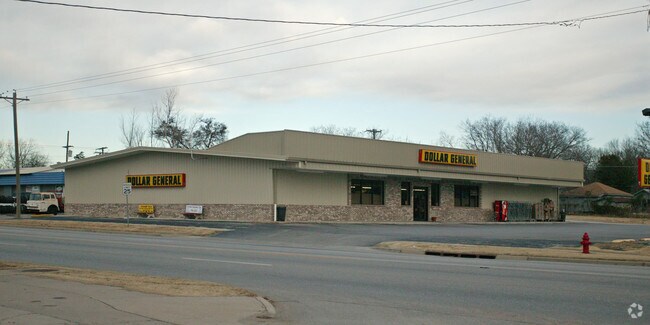
519 E Rogers Blvd, Skiatook, OK 74070

Property Detail
519 E Rogers Blvd
63175-22-23-01320
LTS 5 THRU 10 LESS PRT LT 5 BEG SECR TH W25 NE34.87 S25 POB BLK 15
Departmentstore
Tulsa
CG
Oklahoma
AE The base floodplain where base flood elevations are provided. AE Zones are now used on new format FIRMs instead of A1-A30 Zones.
5
2025
0.48 AC
2025
Northwest Tulsa
005500
Tulsa
9,960 SF
Tulsa, OK
NEARBY LISTINGS FOR SALE OR LEASE
DEMOGRAPHICS near 519 E Rogers Blvd
1 mile
3 mile
5 mile
2025 Total Population
3,577
9,980
14,618
2030 Population
3,705
10,216
14,960
Pop Growth 2025-2030
+ 3.58%
+ 2.36%
+ 2.34%
Average Age
39
39
40
2025 Total Households
1,374
3,713
5,389
HH Growth 2025-2030
+ 3.57%
+ 2.42%
+ 2.38%
Median Household Inc
$49,646
$54,941
$60,147
Avg Household Size
2.60
2.60
2.70
2025 Avg HH Vehicles
2.00
2.00
2.00
Median Home Value
$162,020
$199,815
$245,465
Median Year Built
1976
1985
1987
Nearby Places
Map Layers
Map Styles
 Street
 Aerial
Layers
 Traffic
 Biking
Places
Listings with unknown addresses are not visible on the map
- Restaurants
- Banks
- Shops
- Fitness
- Groceries
PUBLIC TRANSPORTATION
AIRPORT
Tulsa International
Drive
Walk
Distance
Tulsa International
28 min
19.7 mi
Freight Ports
Drive
Walk
Distance
35 min
24.9 mi
Nearby Properties
Address
Land Use
TOTAL SIZE
Lot Size
Zoning
Address
Land Use
TOTAL SIZE
Lot Size
Zoning
88,583 SF
7.78 AC
RS3
Address
Land Use
TOTAL SIZE
Lot Size
Zoning
75,340 SF
3.26 AC
Address
Land Use
TOTAL SIZE
Lot Size
Zoning
21,102 SF
0.88 AC
CH
Address
Land Use
TOTAL SIZE
Lot Size
Zoning
19,388 SF
3.83 AC
RS2
Address
Land Use
TOTAL SIZE
Lot Size
Zoning
1,584 SF
0.42 AC
Address
Land Use
TOTAL SIZE
Lot Size
Zoning
104,473 SF
18.42 AC
Address
Land Use
TOTAL SIZE
Lot Size
Zoning
4,116 SF
0.40 AC
CH
Address
Land Use
TOTAL SIZE
Lot Size
Zoning
6,072 SF
3.90 AC
Address
Land Use
TOTAL SIZE
Lot Size
Zoning
112,015 SF
21.35 AC
Address
Land Use
TOTAL SIZE
Lot Size
Zoning
4,560 SF
0.48 AC
CH
Address
Land Use
TOTAL SIZE
Lot Size
Zoning
17,664 SF
3.69 AC
Address
Land Use
TOTAL SIZE
Lot Size
Zoning
19,200 SF
2.27 AC
Address
Land Use
TOTAL SIZE
Lot Size
Zoning
6,816 SF
1.32 AC
Address
Land Use
TOTAL SIZE
Lot Size
Zoning
5,410 SF
0.08 AC
CH
Address
Land Use
TOTAL SIZE
Lot Size
Zoning
3,294 SF
0.48 AC
Address
Land Use
TOTAL SIZE
Lot Size
Zoning
13,000 SF
0.32 AC
CH
Address
Land Use
TOTAL SIZE
Lot Size
Zoning
7,468 SF
0.92 AC
RS3
Address
Land Use
TOTAL SIZE
Lot Size
Zoning
1,326 SF
0.93 AC
Address
Land Use
TOTAL SIZE
Lot Size
Zoning
6,060 SF
0.48 AC
CH
Address
Land Use
TOTAL SIZE
Lot Size
Zoning
7,199 SF
0.74 AC
CH
Address
Land Use
TOTAL SIZE
Lot Size
Zoning
1,368 SF
0.39 AC
Address
Land Use
TOTAL SIZE
Lot Size
Zoning
6,666 SF
0.47 AC
CG
Address
Land Use
TOTAL SIZE
Lot Size
Zoning
4,610 SF
2.07 AC
Address
Land Use
TOTAL SIZE
Lot Size
Zoning
3,056 SF
0.24 AC
CG
Address
Land Use
TOTAL SIZE
Lot Size
Zoning
7,200 SF
3.31 AC
Address
Land Use
TOTAL SIZE
Lot Size
Zoning
9.35 AC
Address
Land Use
TOTAL SIZE
Lot Size
Zoning
4,050 SF
1.31 AC
Address
Land Use
TOTAL SIZE
Lot Size
Zoning
17,646 SF
1.67 AC
The World's #1 Commercial Real Estate Marketplace
Connect with us
© 2026 CoStar Group
The information above has been obtained from sources believed reliable. While we do not doubt its accuracy we have not verified it and make no guarantee, warranty or representation about it. It is your responsibility to independently confirm its accuracy and completeness. Any projections, opinions, assumptions, or estimates used are for example only and do not represent the current or future performance of the property. The value of this transaction to you depends on tax and other factors which should be evaluated by your tax, financial, and legal advisors. You and your advisors should conduct a careful, independent investigation of the property to determine to your satisfaction the suitability of the property for your needs.