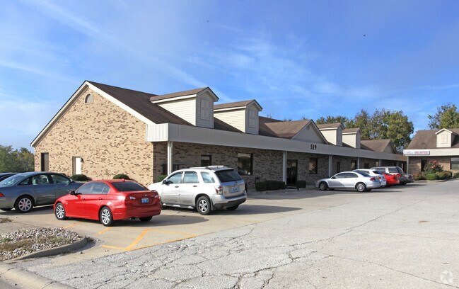
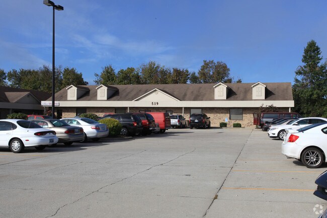
Property Record
519 Hampton Way, Richmond, KY 40475
NEARBY LISTINGS FOR SALE OR LEASE
Property Detail
519 Hampton Way
0042-042B-0100
Crossroad Center Condo
Officebuilding
CROSSROAD CENTER CONDO UNIT 8
X
Madison
21151C0252D
Kentucky
2025
8
2025
Georgetown/Richmond Area
010702
Other Market Areas
1,466 SF
Richmond-Berea, KY
DEMOGRAPHICS near 519 Hampton Way
1 mile
3 mile
5 mile
2024 Total Population
6,406
28,726
47,270
2029 Population
6,998
31,312
51,819
Pop Growth 2024-2029
+ 9.24%
+ 9.00%
+ 9.62%
Average Age
37
36
36
2024 Total Households
2,687
11,630
19,352
HH Growth 2024-2029
+ 9.49%
+ 9.76%
+ 10.08%
Median Household Inc
$46,096
$43,292
$45,900
Avg Household Size
2.30
2.20
2.20
2024 Avg HH Vehicles
2.00
2.00
2.00
Median Home Value
$242,857
$221,083
$220,618
Median Year Built
1994
1990
1993
Nearby Places
Map Layers
Map Styles
 Street
 Aerial
Transit
 Traffic
 Biking
Places
Listings with unknown addresses are not visible on the map
- Restaurants
- Banks
- Shops
- Fitness
- Groceries
PUBLIC TRANSPORTATION
AIRPORT
Blue Grass
Drive
Walk
Distance
Blue Grass
49 min
34.2 mi
Freight Ports
Port of Toledo
Drive
Walk
Distance
Port of Toledo
358 min
311.7 mi
SALE & LEASE HISTORY
LISTING DATE
SALE/LEASE

Nov 15, 2018
For Sale
May 23, 2022
For Sale
Nearby Properties
Address
Land Use
TOTAL SIZE
Lot Size
Zoning
Address
Land Use
TOTAL SIZE
Lot Size
Zoning
Address
Land Use
TOTAL SIZE
Lot Size
Zoning
21.81 AC
Address
Land Use
TOTAL SIZE
Lot Size
Zoning
154,439 SF
23.52 AC
Address
Land Use
TOTAL SIZE
Lot Size
Zoning
195,345 SF
23.98 AC
Address
Land Use
TOTAL SIZE
Lot Size
Zoning
5,776 SF
3.33 AC
Address
Land Use
TOTAL SIZE
Lot Size
Zoning
5.61 AC
Address
Land Use
TOTAL SIZE
Lot Size
Zoning
8,520 SF
12.37 AC
Address
Land Use
TOTAL SIZE
Lot Size
Zoning
10,316 SF
5.87 AC
Address
Land Use
TOTAL SIZE
Lot Size
Zoning
5,625 SF
3.83 AC
Address
Land Use
TOTAL SIZE
Lot Size
Zoning
Address
Land Use
TOTAL SIZE
Lot Size
Zoning
121,085 SF
16.13 AC
Address
Land Use
TOTAL SIZE
Lot Size
Zoning
97,536 SF
8.62 AC
Address
Land Use
TOTAL SIZE
Lot Size
Zoning
28.07 AC
Address
Land Use
TOTAL SIZE
Lot Size
Zoning
1,828 SF
4.38 AC
Address
Land Use
TOTAL SIZE
Lot Size
Zoning
228,982 SF
35.09 AC
Address
Land Use
TOTAL SIZE
Lot Size
Zoning
12,768 SF
5.28 AC
Address
Land Use
TOTAL SIZE
Lot Size
Zoning
77,081 SF
8.03 AC
Address
Land Use
TOTAL SIZE
Lot Size
Zoning
3,540 SF
5.05 AC
Address
Land Use
TOTAL SIZE
Lot Size
Zoning
2.17 AC
Address
Land Use
TOTAL SIZE
Lot Size
Zoning
Address
Land Use
TOTAL SIZE
Lot Size
Zoning
3.90 AC
Address
Land Use
TOTAL SIZE
Lot Size
Zoning
10,658 SF
1.65 AC
Address
Land Use
TOTAL SIZE
Lot Size
Zoning
1.56 AC
Address
Land Use
TOTAL SIZE
Lot Size
Zoning
44.67 AC
Address
Land Use
TOTAL SIZE
Lot Size
Zoning
68,042 SF
18.12 AC
Address
Land Use
TOTAL SIZE
Lot Size
Zoning
1.83 AC
Address
Land Use
TOTAL SIZE
Lot Size
Zoning
2.64 AC
Address
Land Use
TOTAL SIZE
Lot Size
Zoning
60,703 SF
8.12 AC
Address
Land Use
TOTAL SIZE
Lot Size
Zoning
83,352 SF
5.67 AC
Address
Land Use
TOTAL SIZE
Lot Size
Zoning
8,520 SF
3.01 AC
The World's #1 Commercial Real Estate Marketplace
Connect with us
© 2026 CoStar Group
The information above has been obtained from sources believed reliable. While we do not doubt its accuracy we have not verified it and make no guarantee, warranty or representation about it. It is your responsibility to independently confirm its accuracy and completeness. Any projections, opinions, assumptions, or estimates used are for example only and do not represent the current or future performance of the property. The value of this transaction to you depends on tax and other factors which should be evaluated by your tax, financial, and legal advisors. You and your advisors should conduct a careful, independent investigation of the property to determine to your satisfaction the suitability of the property for your needs.