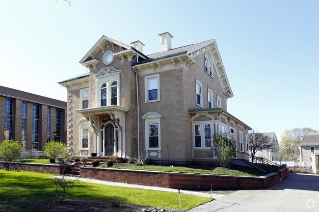
Property Record
519 Main St, Dunstable, MA 01827

Property Detail
519 Main St
DUNS-000017-000113
Middlesex
Commercialofficeresidentialmixeduse
Massachusetts
R1
5
B and X Area of moderate flood hazard, usually the area between the limits of the 100-year and 500-year floods.
2.68 AC
2025
Waltham
2025
Boston
368901
Boston-Cambridge-Newton, MA-NH
NEARBY LISTINGS FOR SALE OR LEASE
DEMOGRAPHICS near 519 Main St
1 mile
3 mile
5 mile
2025 Total Population
29,849
146,571
347,072
2030 Population
30,748
151,610
358,833
Pop Growth 2025-2030
+ 3.01%
+ 3.44%
+ 3.39%
Average Age
38
40
41
2025 Total Households
12,286
58,195
135,823
HH Growth 2025-2030
+ 3.26%
+ 3.59%
+ 3.57%
Median Household Inc
$98,146
$129,571
$139,391
Avg Household Size
2.20
2.30
2.40
2025 Avg HH Vehicles
1.00
2.00
2.00
Median Home Value
$740,740
$871,887
$981,226
Median Year Built
1952
1952
1952
Nearby Places
Map Layers
Map Styles
 Street
 Aerial
Layers
 Traffic
 Biking
Places
Listings with unknown addresses are not visible on the map
- Restaurants
- Banks
- Shops
- Fitness
- Groceries
PUBLIC TRANSPORTATION
AIRPORT
Manchester Boston Regional
Drive
Walk
Distance
Manchester Boston Regional
37 min
21.4 mi
Freight Ports
Port of Boston
Drive
Walk
Distance
Port of Boston
62 min
44.0 mi
Nearby Properties
Address
Land Use
TOTAL SIZE
Lot Size
Zoning
Address
Land Use
TOTAL SIZE
Lot Size
Zoning
38.17 AC
RC
Address
Land Use
TOTAL SIZE
Lot Size
Zoning
29.77 AC
RC
Address
Land Use
TOTAL SIZE
Lot Size
Zoning
80.11 AC
PI
Address
Land Use
TOTAL SIZE
Lot Size
Zoning
118.50 AC
PI
Address
Land Use
TOTAL SIZE
Lot Size
Zoning
52.45 AC
R18
Address
Land Use
TOTAL SIZE
Lot Size
Zoning
127,494 SF
9.09 AC
GB
Address
Land Use
TOTAL SIZE
Lot Size
Zoning
199.97 AC
B2
Address
Land Use
TOTAL SIZE
Lot Size
Zoning
21.17 AC
RC
Address
Land Use
TOTAL SIZE
Lot Size
Zoning
8.09 AC
RC
Address
Land Use
TOTAL SIZE
Lot Size
Zoning
154,620 SF
8.63 AC
GB
Address
Land Use
TOTAL SIZE
Lot Size
Zoning
12.57 AC
RC
Address
Land Use
TOTAL SIZE
Lot Size
Zoning
233,668 SF
16.83 AC
PI
Address
Land Use
TOTAL SIZE
Lot Size
Zoning
144,018 SF
13.89 AC
PI
Address
Land Use
TOTAL SIZE
Lot Size
Zoning
161,790 SF
9 AC
PI
Address
Land Use
TOTAL SIZE
Lot Size
Zoning
135,324 SF
70.07 AC
R1
Address
Land Use
TOTAL SIZE
Lot Size
Zoning
120,888 SF
11.78 AC
HB
Address
Land Use
TOTAL SIZE
Lot Size
Zoning
7.21 AC
RC
Address
Land Use
TOTAL SIZE
Lot Size
Zoning
80,021 SF
4.55 AC
PI
Address
Land Use
TOTAL SIZE
Lot Size
Zoning
95,040 SF
7.33 AC
RC
Address
Land Use
TOTAL SIZE
Lot Size
Zoning
146,536 SF
7.45 AC
GB
Address
Land Use
TOTAL SIZE
Lot Size
Zoning
77,760 SF
5.76 AC
RC
Address
Land Use
TOTAL SIZE
Lot Size
Zoning
58,660 SF
6.13 AC
RC
Address
Land Use
TOTAL SIZE
Lot Size
Zoning
56,165 SF
7.25 AC
R18
Address
Land Use
TOTAL SIZE
Lot Size
Zoning
93,416 SF
4.61 AC
PI
Address
Land Use
TOTAL SIZE
Lot Size
Zoning
15.86 AC
B3
Address
Land Use
TOTAL SIZE
Lot Size
Zoning
6.64 AC
R40
Address
Land Use
TOTAL SIZE
Lot Size
Zoning
58,486 SF
1.77 AC
HB
Address
Land Use
TOTAL SIZE
Lot Size
Zoning
44,100 SF
2.72 AC
HB
Address
Land Use
TOTAL SIZE
Lot Size
Zoning
61,474 SF
11.26 AC
R18
The World's #1 Commercial Real Estate Marketplace
Connect with us
© 2026 CoStar Group
The information above has been obtained from sources believed reliable. While we do not doubt its accuracy we have not verified it and make no guarantee, warranty or representation about it. It is your responsibility to independently confirm its accuracy and completeness. Any projections, opinions, assumptions, or estimates used are for example only and do not represent the current or future performance of the property. The value of this transaction to you depends on tax and other factors which should be evaluated by your tax, financial, and legal advisors. You and your advisors should conduct a careful, independent investigation of the property to determine to your satisfaction the suitability of the property for your needs.