Property Record
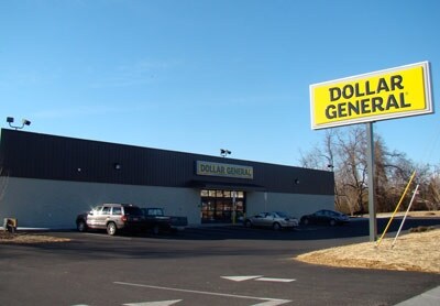
519 Morgan Rd, Eden, NC 27288

Property Detail
519 Morgan Rd
176111
1.41 AC DAVID COOK LOTS & ADDL LOT HUBBARD SURVEY HUBBARD SURVEY
Storebuilding
Rockingham
GEN BUS ED
North Carolina
B and X Area of moderate flood hazard, usually the area between the limits of the 100-year and 500-year floods.
1.41 AC
2025
Rockingham County
2025
Greensboro/Winston-Salem
040400
Greensboro-High Point, NC
10,640 SF
NEARBY LISTINGS FOR SALE OR LEASE
DEMOGRAPHICS near 519 Morgan Rd
1 mile
3 mile
5 mile
2025 Total Population
3,342
16,347
25,542
2030 Population
3,481
16,901
26,292
Pop Growth 2025-2030
+ 4.16%
+ 3.39%
+ 2.94%
Average Age
41
43
43
2025 Total Households
1,406
7,200
11,078
HH Growth 2025-2030
+ 4.27%
+ 3.35%
+ 2.92%
Median Household Inc
$65,795
$59,716
$56,883
Avg Household Size
2.30
2.20
2.30
2025 Avg HH Vehicles
2.00
2.00
2.00
Median Home Value
$86,226
$134,669
$139,447
Median Year Built
1959
1969
1970
Nearby Places
Map Layers
Map Styles
 Street
 Aerial
Layers
 Traffic
 Biking
Places
Listings with unknown addresses are not visible on the map
- Restaurants
- Banks
- Shops
- Fitness
- Groceries
PUBLIC TRANSPORTATION
AIRPORT
Piedmont Triad International
Drive
Walk
Distance
Piedmont Triad International
57 min
38.5 mi
Nearby Properties
Address
Land Use
TOTAL SIZE
Lot Size
Zoning
Address
Land Use
TOTAL SIZE
Lot Size
Zoning
1,094,878 SF
61.89 AC
LIGHT INDU
Address
Land Use
TOTAL SIZE
Lot Size
Zoning
51,491 SF
22.80 AC
NEIGHBORHO
Address
Land Use
TOTAL SIZE
Lot Size
Zoning
73,711 SF
42.90 AC
RES 20 EDE
Address
Land Use
TOTAL SIZE
Lot Size
Zoning
192,057 SF
21.83 AC
HWY BUS ED
Address
Land Use
TOTAL SIZE
Lot Size
Zoning
161,928 SF
22.72 AC
LIGHT INDU
Address
Land Use
TOTAL SIZE
Lot Size
Zoning
101,162 SF
23.77 AC
NEIGHBORHO
Address
Land Use
TOTAL SIZE
Lot Size
Zoning
76,404 SF
4.24 AC
RES 12 EDE
Address
Land Use
TOTAL SIZE
Lot Size
Zoning
27,040 SF
605.77 AC
HEAVY INDU
Address
Land Use
TOTAL SIZE
Lot Size
Zoning
71,755 SF
10 AC
NEIGHBORHO
Address
Land Use
TOTAL SIZE
Lot Size
Zoning
9,008 SF
7.40 AC
NEIGHBORHO
Address
Land Use
TOTAL SIZE
Lot Size
Zoning
57,000 SF
1.58 AC
HWY BUS ED
Address
Land Use
TOTAL SIZE
Lot Size
Zoning
37,634 SF
10.21 AC
RES 20 EDE
Address
Land Use
TOTAL SIZE
Lot Size
Zoning
36,266 SF
4.18 AC
HWY BUS ED
Address
Land Use
TOTAL SIZE
Lot Size
Zoning
25,844 SF
11.81 AC
NEIGHBORHO
Address
Land Use
TOTAL SIZE
Lot Size
Zoning
143,646 SF
12.47 AC
HWY BUS ED
Address
Land Use
TOTAL SIZE
Lot Size
Zoning
59,165 SF
6.56 AC
HWY BUS ED
Address
Land Use
TOTAL SIZE
Lot Size
Zoning
448,877 SF
41.62 AC
LIGHT INDU
Address
Land Use
TOTAL SIZE
Lot Size
Zoning
95,156 SF
16.50 AC
HWY BUS ED
Address
Land Use
TOTAL SIZE
Lot Size
Zoning
52,332 SF
14.20 AC
RES 20 EDE
Address
Land Use
TOTAL SIZE
Lot Size
Zoning
31,464 SF
4.42 AC
HWY BUS ED
Address
Land Use
TOTAL SIZE
Lot Size
Zoning
88,170 SF
15.39 AC
RES 12 EDE
Address
Land Use
TOTAL SIZE
Lot Size
Zoning
46,226 SF
44.93 AC
RES 20 EDE
Address
Land Use
TOTAL SIZE
Lot Size
Zoning
172,252 SF
17 AC
LIGHT INDU
Address
Land Use
TOTAL SIZE
Lot Size
Zoning
6,370 SF
8.60 AC
NEIGHBORHO
Address
Land Use
TOTAL SIZE
Lot Size
Zoning
85,306 SF
14.78 AC
LIGHT INDU
Address
Land Use
TOTAL SIZE
Lot Size
Zoning
39,876 SF
4.20 AC
NEIGHBORHO
Address
Land Use
TOTAL SIZE
Lot Size
Zoning
552,147 SF
25.12 AC
LIGHT INDU
Address
Land Use
TOTAL SIZE
Lot Size
Zoning
19,966 SF
2 AC
NEIGHBORHO
Address
Land Use
TOTAL SIZE
Lot Size
Zoning
31,800 SF
4.14 AC
GEN BUS ED
Address
Land Use
TOTAL SIZE
Lot Size
Zoning
7,482 SF
3.76 AC
RES MIXED
The World's #1 Commercial Real Estate Marketplace
Connect with us
© 2026 CoStar Group
The information above has been obtained from sources believed reliable. While we do not doubt its accuracy we have not verified it and make no guarantee, warranty or representation about it. It is your responsibility to independently confirm its accuracy and completeness. Any projections, opinions, assumptions, or estimates used are for example only and do not represent the current or future performance of the property. The value of this transaction to you depends on tax and other factors which should be evaluated by your tax, financial, and legal advisors. You and your advisors should conduct a careful, independent investigation of the property to determine to your satisfaction the suitability of the property for your needs.