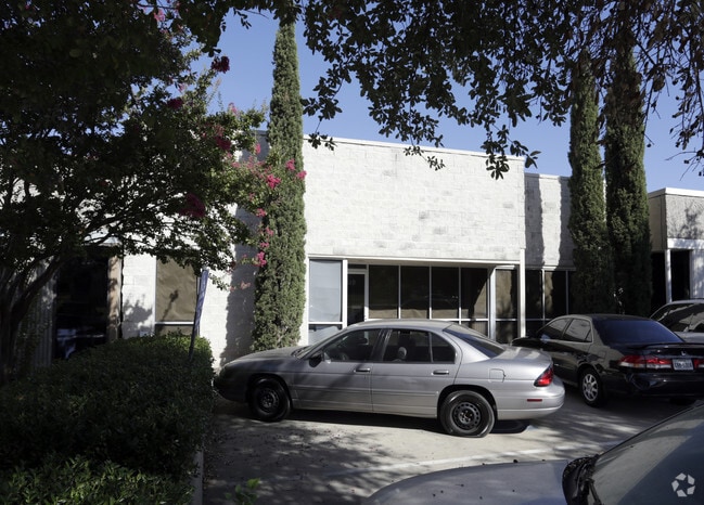
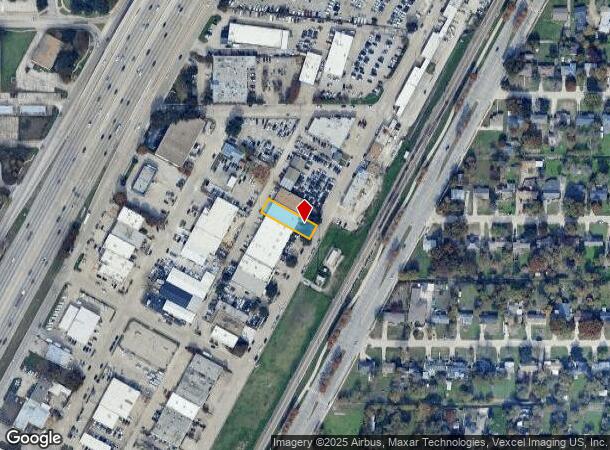
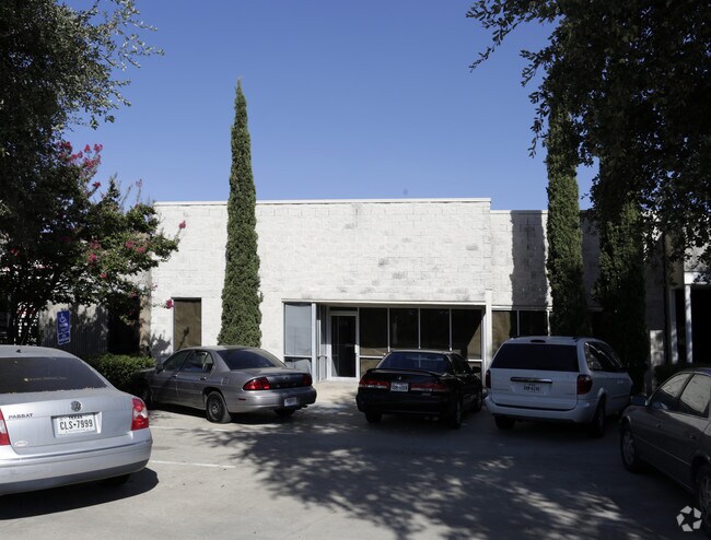
Property Record
519 N Interurban St, Richardson, TX 75081
NEARBY LISTINGS FOR SALE OR LEASE
Property Detail
519 N Interurban St
Dallas-Fort Worth-Arlington, TX
North Richardson
42108500040230000
NORTH RICHARDSON BLK 4 LOT 23 INT202300158951 DD12312022 CO-DC 1085000402300 34210850004
Warehouse
Dallas
X
Texas
48085C0505K
23
2024
0.21 AC
2025
Richardson
019039
Dallas/Ft Worth
4,933 SF
DEMOGRAPHICS near 519 N Interurban St
1 Mile
3 Mile
5 Mile
2024 Total Population
10,328
140,733
378,241
2029 Population
10,222
142,684
393,338
Pop Growth 2024-2029
(1.03%)
+ 1.39%
+ 3.99%
Average Age
39
36
38
2024 Total Households
4,289
51,558
152,007
HH Growth 2024-2029
(1.26%)
+ 1.57%
+ 4.67%
Median Household Inc
$68,557
$68,906
$66,131
Avg Household Size
2.30
2.50
2.40
2024 Avg HH Vehicles
2.00
2.00
2.00
Median Home Value
$280,146
$321,929
$343,468
Median Year Built
1964
1976
1980
Nearby Places
Map Layers
Map Styles
 Street
 Aerial
- Restaurants
- Banks
- Shops
- Fitness
- Groceries
PUBLIC TRANSPORTATION
TRANSIT/SUBWAY
Arapaho Center (DART LIGHT RAIL - ORANGE LINE - Dallas Area Rapid Transit (DART), DART LIGHT RAIL - RED LINE - Dallas Area Rapid Transit (DART), Orange Line - Dallas Area Rapid Transit (DART), Red Line - Dallas Area Rapid Transit (DART))
DRIVE
WALK
Distance
Arapaho Center (DART LIGHT RAIL - ORANGE LINE - Dallas Area Rapid Transit (DART), DART LIGHT RAIL - RED LINE - Dallas Area Rapid Transit (DART), Orange Line - Dallas Area Rapid Transit (DART), Red Line - Dallas Area Rapid Transit (DART))
2 min
11 min
0.6 mi
AIRPORT
Dallas Love Field
DRIVE
WALK
Distance
Dallas Love Field
23 min
16.1 mi
Dallas-Fort Worth International
DRIVE
WALK
Distance
Dallas-Fort Worth International
31 min
25.0 mi
Freight Ports
Port of Shreveport
DRIVE
WALK
Distance
Port of Shreveport
218 min
200.3 mi
Nearby Properties
Address
Land Use
TOTAL SIZE
Lot Size
Zoning
Address
Land Use
TOTAL SIZE
Lot Size
Zoning
1,050,550 SF
18.24 AC
Address
Land Use
TOTAL SIZE
Lot Size
Zoning
7,706,477 SF
245.55 AC
Z116
Address
Land Use
TOTAL SIZE
Lot Size
Zoning
641,243 SF
20.67 AC
Z109
Address
Land Use
TOTAL SIZE
Lot Size
Zoning
686,032 SF
9 AC
R2000
Address
Land Use
TOTAL SIZE
Lot Size
Zoning
369,694 SF
Address
Land Use
TOTAL SIZE
Lot Size
Zoning
445,071 SF
107.94 AC
2493-A TO-
Address
Land Use
TOTAL SIZE
Lot Size
Zoning
595,150 SF
17.20 AC
MF-H
Address
Land Use
TOTAL SIZE
Lot Size
Zoning
487,093 SF
6.28 AC
MF-E
Address
Land Use
TOTAL SIZE
Lot Size
Zoning
507,693 SF
32.50 AC
MFL
Address
Land Use
TOTAL SIZE
Lot Size
Zoning
393,416 SF
Address
Land Use
TOTAL SIZE
Lot Size
Zoning
706,061 SF
36.76 AC
Z109
Address
Land Use
TOTAL SIZE
Lot Size
Zoning
428,956 SF
18.76 AC
Z291
Address
Land Use
TOTAL SIZE
Lot Size
Zoning
386,448 SF
Address
Land Use
TOTAL SIZE
Lot Size
Zoning
129,810 SF
14.93 AC
Z236
Address
Land Use
TOTAL SIZE
Lot Size
Zoning
795,714 SF
5.36 AC
Z109
Address
Land Use
TOTAL SIZE
Lot Size
Zoning
249,692 SF
244.62 AC
Z239
Address
Land Use
TOTAL SIZE
Lot Size
Zoning
402,815 SF
5.64 AC
Z236
Address
Land Use
TOTAL SIZE
Lot Size
Zoning
537,928 SF
11.13 AC
Z109
Address
Land Use
TOTAL SIZE
Lot Size
Zoning
426,467 SF
24.12 AC
Z142
Address
Land Use
TOTAL SIZE
Lot Size
Zoning
681,916 SF
4.80 AC
Z31
Address
Land Use
TOTAL SIZE
Lot Size
Zoning
1,464,834 SF
18.37 AC
Z109
Address
Land Use
TOTAL SIZE
Lot Size
Zoning
211,607 SF
Address
Land Use
TOTAL SIZE
Lot Size
Zoning
542,845 SF
3.90 AC
MF-R
Address
Land Use
TOTAL SIZE
Lot Size
Zoning
316,085 SF
13.73 AC
Z107
Address
Land Use
TOTAL SIZE
Lot Size
Zoning
596,546 SF
3.61 AC
Z31
Address
Land Use
TOTAL SIZE
Lot Size
Zoning
302,594 SF
16.02 AC
TO-M
Address
Land Use
TOTAL SIZE
Lot Size
Zoning
371,611 SF
4.48 AC
Z31
Address
Land Use
TOTAL SIZE
Lot Size
Zoning
470,129 SF
4.43 AC
Z112
Address
Land Use
TOTAL SIZE
Lot Size
Zoning
333,963 SF
7.75 AC
MF-E
The World's #1 Commercial Real Estate Marketplace
Connect with us
© 2025 CoStar Group
The information above has been obtained from sources believed reliable. While we do not doubt its accuracy we have not verified it and make no guarantee, warranty or representation about it. It is your responsibility to independently confirm its accuracy and completeness. Any projections, opinions, assumptions, or estimates used are for example only and do not represent the current or future performance of the property. The value of this transaction to you depends on tax and other factors which should be evaluated by your tax, financial, and legal advisors. You and your advisors should conduct a careful, independent investigation of the property to determine to your satisfaction the suitability of the property for your needs.