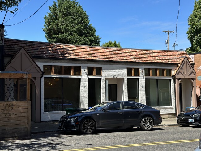
Property Record
519 Nw 21St Ave, Portland, OR 97209


NEARBY LISTINGS FOR SALE OR LEASE
Property Detail
519 Nw 21St Ave
Portland-Vancouver-Hillsboro, OR-WA
Kings 2Nd Add
R198579
KINGS 2ND ADD, BLOCK 18, LOT 2 TL 6600
Commercialnec
Multnomah
ARE
Oregon
41067C0400E
2
2025
0.06 AC
2025
NW Close-In
004800
Portland
2,438 SF
DEMOGRAPHICS near 519 Nw 21St Ave
1 Mile
3 Mile
5 Mile
2024 Total Population
49,729
167,771
410,992
2029 Population
49,493
167,459
405,920
Pop Growth 2024-2029
(0.47%)
(0.19%)
(1.23%)
Average Age
41
40
40
2024 Total Households
31,079
90,415
192,112
HH Growth 2024-2029
(0.63%)
(0.22%)
(1.27%)
Median Household Inc
$69,639
$80,368
$91,311
Avg Household Size
1.50
1.80
2.00
2024 Avg HH Vehicles
1.00
1.00
1.00
Median Home Value
$751,171
$726,592
$683,600
Median Year Built
1991
1977
1964
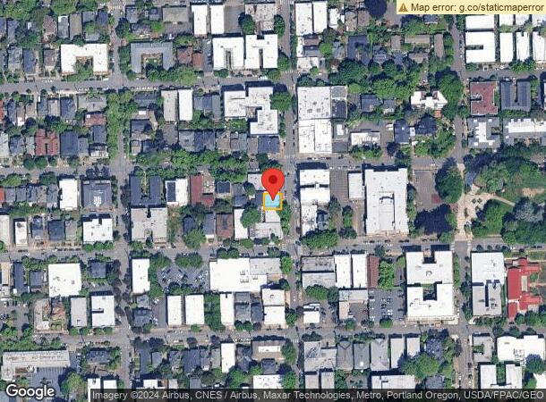
Nearby Places
Map Layers
Map Styles
 Street
 Aerial
- Restaurants
- Banks
- Shops
- Fitness
- Groceries
PUBLIC TRANSPORTATION
TRANSIT/SUBWAY
NW 21st & Lovejoy (Portland Streetcar - Tri-County Metropolitan Transportation District of Oregon Rail (TriMet Rail))
DRIVE
WALK
Distance
NW 21st & Lovejoy (Portland Streetcar - Tri-County Metropolitan Transportation District of Oregon Rail (TriMet Rail))
3 min
5 min
0.2 mi
NW 22nd & Lovejoy (Portland Streetcar - Tri-County Metropolitan Transportation District of Oregon Rail (TriMet Rail))
DRIVE
WALK
Distance
NW 22nd & Lovejoy (Portland Streetcar - Tri-County Metropolitan Transportation District of Oregon Rail (TriMet Rail))
3 min
7 min
0.3 mi
NW 21st & Northrup (Portland Streetcar - Tri-County Metropolitan Transportation District of Oregon Rail (TriMet Rail))
DRIVE
WALK
Distance
NW 21st & Northrup (Portland Streetcar - Tri-County Metropolitan Transportation District of Oregon Rail (TriMet Rail))
3 min
7 min
0.3 mi
NW 22nd & Northrup (Portland Streetcar - Tri-County Metropolitan Transportation District of Oregon Rail (TriMet Rail))
DRIVE
WALK
Distance
NW 22nd & Northrup (Portland Streetcar - Tri-County Metropolitan Transportation District of Oregon Rail (TriMet Rail))
3 min
8 min
0.4 mi
NW 18th & Lovejoy (Portland Streetcar - Tri-County Metropolitan Transportation District of Oregon Rail (TriMet Rail))
DRIVE
WALK
Distance
NW 18th & Lovejoy (Portland Streetcar - Tri-County Metropolitan Transportation District of Oregon Rail (TriMet Rail))
3 min
9 min
0.5 mi
COMMUTER RAIL
Beaverton Transit Center (West Side Express) (Westside Express Service - Tri-County Metropolitan Transportation District of Oregon Rail (TriMet Rail))
DRIVE
WALK
Distance
Beaverton Transit Center (West Side Express) (Westside Express Service - Tri-County Metropolitan Transportation District of Oregon Rail (TriMet Rail))
13 min
8.3 mi
AIRPORT
Portland International
DRIVE
WALK
Distance
Portland International
22 min
15.2 mi
SALE & LEASE HISTORY
LISTING DATE
SALE/LEASE

Sep 25, 2016
For Lease
Sep 24, 2016
For Sale
Sep 05, 2019
For Lease
May 14, 2021
For Sale
Mar 25, 2025
For Lease
Mar 25, 2025
For Sale
Jul 18, 2019
For Sale
Dec 08, 2016
For Sale
Aug 22, 2024
For Sale
Nearby Properties
Address
Land Use
TOTAL SIZE
Lot Size
Zoning
Address
Land Use
TOTAL SIZE
Lot Size
Zoning
395,815 SF
2.66 AC
IRD
Address
Land Use
TOTAL SIZE
Lot Size
Zoning
27.58 AC
EX
Address
Land Use
TOTAL SIZE
Lot Size
Zoning
627,500 SF
16.60 AC
CX
Address
Land Use
TOTAL SIZE
Lot Size
Zoning
57,314 SF
60.69 AC
OS
Address
Land Use
TOTAL SIZE
Lot Size
Zoning
560,000 SF
0.15 AC
CX
Address
Land Use
TOTAL SIZE
Lot Size
Zoning
20.71 AC
OS
Address
Land Use
TOTAL SIZE
Lot Size
Zoning
409,260 SF
7.41 AC
EX
Address
Land Use
TOTAL SIZE
Lot Size
Zoning
1.09 AC
EX
Address
Land Use
TOTAL SIZE
Lot Size
Zoning
2.24 AC
CX
Address
Land Use
TOTAL SIZE
Lot Size
Zoning
326,547 SF
2.42 AC
RH
Address
Land Use
TOTAL SIZE
Lot Size
Zoning
304,836 SF
10.85 AC
CX
Address
Land Use
TOTAL SIZE
Lot Size
Zoning
417,324 SF
0.68 AC
CX
Address
Land Use
TOTAL SIZE
Lot Size
Zoning
598,328 SF
12.32 AC
CX
Address
Land Use
TOTAL SIZE
Lot Size
Zoning
257,700 SF
2.89 AC
EX
Address
Land Use
TOTAL SIZE
Lot Size
Zoning
128,500 SF
6.95 AC
OS
Address
Land Use
TOTAL SIZE
Lot Size
Zoning
460,000 SF
0.92 AC
CX
Address
Land Use
TOTAL SIZE
Lot Size
Zoning
689,840 SF
0.92 AC
CX
Address
Land Use
TOTAL SIZE
Lot Size
Zoning
125,217 SF
0.23 AC
CX
Address
Land Use
TOTAL SIZE
Lot Size
Zoning
97,465 SF
107.18 AC
OS
Address
Land Use
TOTAL SIZE
Lot Size
Zoning
7.78 AC
EX
Address
Land Use
TOTAL SIZE
Lot Size
Zoning
426,742 SF
0.53 AC
RXD
Address
Land Use
TOTAL SIZE
Lot Size
Zoning
243,371 SF
0.67 AC
CI2
Address
Land Use
TOTAL SIZE
Lot Size
Zoning
584,483 SF
0.90 AC
CX
Address
Land Use
TOTAL SIZE
Lot Size
Zoning
645,294 SF
5.64 AC
CO2D
Address
Land Use
TOTAL SIZE
Lot Size
Zoning
247,520 SF
7.74 AC
CX
Address
Land Use
TOTAL SIZE
Lot Size
Zoning
306,000 SF
1.21 AC
NULL
Address
Land Use
TOTAL SIZE
Lot Size
Zoning
596,161 SF
0.92 AC
CX
Address
Land Use
TOTAL SIZE
Lot Size
Zoning
456,760 SF
0.53 AC
EX
Address
Land Use
TOTAL SIZE
Lot Size
Zoning
193,898 SF
2.50 AC
IRD
Address
Land Use
TOTAL SIZE
Lot Size
Zoning
134,398 SF
3.17 AC
CG
The World's #1 Commercial Real Estate Marketplace
Connect with us
© 2026 CoStar Group
The information above has been obtained from sources believed reliable. While we do not doubt its accuracy we have not verified it and make no guarantee, warranty or representation about it. It is your responsibility to independently confirm its accuracy and completeness. Any projections, opinions, assumptions, or estimates used are for example only and do not represent the current or future performance of the property. The value of this transaction to you depends on tax and other factors which should be evaluated by your tax, financial, and legal advisors. You and your advisors should conduct a careful, independent investigation of the property to determine to your satisfaction the suitability of the property for your needs.