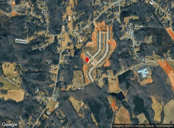
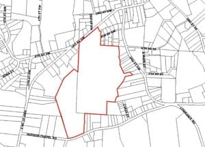
Property Record
5198 Hudson Chapel Rd, Catawba, NC 28609

NEARBY LISTINGS FOR SALE OR LEASE
-
-
View all Catawba listings for sale on LoopNet.com
Property Detail
5198 Hudson Chapel Rd
3781091585810000
Bowden Survey & Mapping
Agriculturalland
5198 HUDSON CHAPEL RD
X
Catawba
3710378100K
North Carolina
2024
21.17 AC
2024
Catawba County
011501
Charlotte
1,364 SF
Hickory-Lenoir-Morganton, NC
DEMOGRAPHICS near 5198 Hudson Chapel Rd
1 Mile
3 Mile
5 Mile
2024 Total Population
745
4,027
14,032
2029 Population
763
4,194
14,802
Pop Growth 2024-2029
+ 2.42%
+ 4.15%
+ 5.49%
Average Age
42
42
42
2024 Total Households
315
1,632
5,531
HH Growth 2024-2029
+ 2.22%
+ 4.04%
+ 5.46%
Median Household Inc
$49,166
$59,736
$60,510
Avg Household Size
2.40
2.40
2.50
2024 Avg HH Vehicles
3.00
2.00
2.00
Median Home Value
$152,409
$182,410
$189,194
Median Year Built
1973
1982
1986
Nearby Places
Map Layers
Map Styles
 Street
 Aerial
- Restaurants
- Banks
- Shops
- Fitness
- Groceries
Nearby Properties
Address
Land Use
TOTAL SIZE
Lot Size
Zoning
Address
Land Use
TOTAL SIZE
Lot Size
Zoning
313,228 SF
256.31 AC
M-I
Address
Land Use
TOTAL SIZE
Lot Size
Zoning
136,792 SF
21.39 AC
M-I
Address
Land Use
TOTAL SIZE
Lot Size
Zoning
22.57 AC
R-1
Address
Land Use
TOTAL SIZE
Lot Size
Zoning
298,120 SF
126.43 AC
M-I
Address
Land Use
TOTAL SIZE
Lot Size
Zoning
6,048 SF
94.94 AC
M2
Address
Land Use
TOTAL SIZE
Lot Size
Zoning
43,959 SF
3.03 AC
R-1
Address
Land Use
TOTAL SIZE
Lot Size
Zoning
7,726 SF
18.71 AC
R-20
Address
Land Use
TOTAL SIZE
Lot Size
Zoning
13,559 SF
6.96 AC
R-A
Address
Land Use
TOTAL SIZE
Lot Size
Zoning
45,300 SF
45.21 AC
LI
Address
Land Use
TOTAL SIZE
Lot Size
Zoning
3,283 SF
14.99 AC
M-1
Address
Land Use
TOTAL SIZE
Lot Size
Zoning
6,584 SF
1.73 AC
R-1
Address
Land Use
TOTAL SIZE
Lot Size
Zoning
9,301 SF
1 AC
H-B
Address
Land Use
TOTAL SIZE
Lot Size
Zoning
13,650 SF
0.19 AC
B-1
Address
Land Use
TOTAL SIZE
Lot Size
Zoning
14,786 SF
2.55 AC
M-I
Address
Land Use
TOTAL SIZE
Lot Size
Zoning
7,574 SF
0.75 AC
B-1
Address
Land Use
TOTAL SIZE
Lot Size
Zoning
3,400 SF
6.97 AC
R-1
Address
Land Use
TOTAL SIZE
Lot Size
Zoning
2,520 SF
14.85 AC
GI
Address
Land Use
TOTAL SIZE
Lot Size
Zoning
115.90 AC
RA
Address
Land Use
TOTAL SIZE
Lot Size
Zoning
9,328 SF
6.63 AC
R-1
Address
Land Use
TOTAL SIZE
Lot Size
Zoning
14,040 SF
2.80 AC
M-1
Address
Land Use
TOTAL SIZE
Lot Size
Zoning
4,688 SF
2.60 AC
R-1
Address
Land Use
TOTAL SIZE
Lot Size
Zoning
3,790 SF
0.86 AC
R-1
Address
Land Use
TOTAL SIZE
Lot Size
Zoning
6,574 SF
1.64 AC
R-1
Address
Land Use
TOTAL SIZE
Lot Size
Zoning
2,500 SF
1.81 AC
RC
Address
Land Use
TOTAL SIZE
Lot Size
Zoning
6,207 SF
1.24 AC
M-I
Address
Land Use
TOTAL SIZE
Lot Size
Zoning
4,712 SF
7.98 AC
R-40
Address
Land Use
TOTAL SIZE
Lot Size
Zoning
11,025 SF
2.17 AC
M-I
Address
Land Use
TOTAL SIZE
Lot Size
Zoning
2,901 SF
0.54 AC
R-20
Address
Land Use
TOTAL SIZE
Lot Size
Zoning
2,969 SF
0.94 AC
B-1
Address
Land Use
TOTAL SIZE
Lot Size
Zoning
19,870 SF
2.88 AC
M-1
The World's #1 Commercial Real Estate Marketplace
Connect with us
© 2025 CoStar Group
The information above has been obtained from sources believed reliable. While we do not doubt its accuracy we have not verified it and make no guarantee, warranty or representation about it. It is your responsibility to independently confirm its accuracy and completeness. Any projections, opinions, assumptions, or estimates used are for example only and do not represent the current or future performance of the property. The value of this transaction to you depends on tax and other factors which should be evaluated by your tax, financial, and legal advisors. You and your advisors should conduct a careful, independent investigation of the property to determine to your satisfaction the suitability of the property for your needs.