Property Record
52 Main St, Newcastle, ME 04553

Property Detail
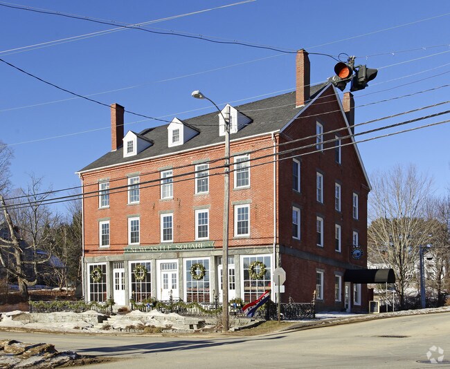
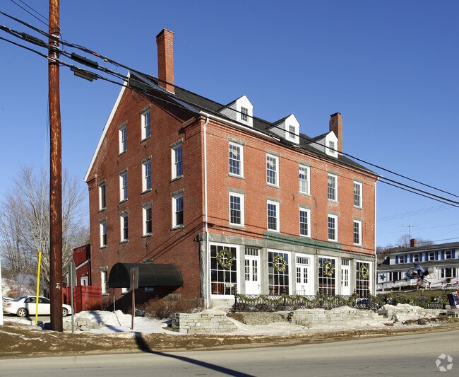
52 Main St
Restaurantbuilding
LINCOLN
12
Maine
B and X Area of moderate flood hazard, usually the area between the limits of the 100-year and 500-year floods.
24
2025
2.16 AC
2025
Maine Midcoast
975400
Other Market Areas
7,425 SF
NEWC-000012-000000-000024
NEARBY LISTINGS FOR SALE OR LEASE
-
-
View all Newcastle listings for sale on LoopNet.com
DEMOGRAPHICS near 52 Main St
1 mile
3 mile
5 mile
2025 Total Population
1,186
2,933
5,829
2030 Population
1,167
2,877
5,764
Pop Growth 2025-2030
(1.60%)
(1.91%)
(1.12%)
Average Age
49
48
48
2025 Total Households
524
1,306
2,576
HH Growth 2025-2030
(2.10%)
(2.30%)
(1.44%)
Median Household Inc
$70,908
$70,674
$77,815
Avg Household Size
2.20
2.10
2.20
2025 Avg HH Vehicles
2.00
2.00
2.00
Median Home Value
$407,576
$400,427
$392,057
Median Year Built
1984
1984
1983
Nearby Places
Map Layers
Map Styles
 Street
 Aerial
Layers
 Traffic
 Biking
Places
Listings with unknown addresses are not visible on the map
- Restaurants
- Banks
- Shops
- Fitness
- Groceries
Nearby Properties
Address
Land Use
TOTAL SIZE
Lot Size
Zoning
Address
Land Use
TOTAL SIZE
Lot Size
Zoning
137,998 SF
8.54 AC
Address
Land Use
TOTAL SIZE
Lot Size
Zoning
17,236 SF
17 AC
RA
Address
Land Use
TOTAL SIZE
Lot Size
Zoning
29,864 SF
4.93 AC
RB
Address
Land Use
TOTAL SIZE
Lot Size
Zoning
60,703 SF
21.38 AC
RB
Address
Land Use
TOTAL SIZE
Lot Size
Zoning
36,372 SF
5.22 AC
RB
Address
Land Use
TOTAL SIZE
Lot Size
Zoning
115,200 SF
20.81 AC
RURAL
Address
Land Use
TOTAL SIZE
Lot Size
Zoning
52,725 SF
24 AC
RB
Address
Land Use
TOTAL SIZE
Lot Size
Zoning
12,487 SF
7 AC
RA
Address
Land Use
TOTAL SIZE
Lot Size
Zoning
31,260 SF
3.67 AC
Address
Land Use
TOTAL SIZE
Lot Size
Zoning
6,566 SF
0.60 AC
RB
Address
Land Use
TOTAL SIZE
Lot Size
Zoning
38.84 AC
SEASON
Address
Land Use
TOTAL SIZE
Lot Size
Zoning
42,700 SF
9 AC
RB
Address
Land Use
TOTAL SIZE
Lot Size
Zoning
13,371 SF
0.19 AC
RB
Address
Land Use
TOTAL SIZE
Lot Size
Zoning
5,634 SF
0.95 AC
RA
Address
Land Use
TOTAL SIZE
Lot Size
Zoning
59,450 SF
14.27 AC
RB
Address
Land Use
TOTAL SIZE
Lot Size
Zoning
17,115 SF
5 AC
RB
Address
Land Use
TOTAL SIZE
Lot Size
Zoning
27,324 SF
3.02 AC
RB
Address
Land Use
TOTAL SIZE
Lot Size
Zoning
34,372 SF
10.54 AC
RB
Address
Land Use
TOTAL SIZE
Lot Size
Zoning
7,440 SF
1.87 AC
RB
Address
Land Use
TOTAL SIZE
Lot Size
Zoning
7,336 SF
0.55 AC
RA
Address
Land Use
TOTAL SIZE
Lot Size
Zoning
7,316 SF
0.47 AC
RB
Address
Land Use
TOTAL SIZE
Lot Size
Zoning
7,459 SF
13.35 AC
Address
Land Use
TOTAL SIZE
Lot Size
Zoning
8,680 SF
0.73 AC
11
Address
Land Use
TOTAL SIZE
Lot Size
Zoning
19,698 SF
RB
Address
Land Use
TOTAL SIZE
Lot Size
Zoning
7,860 SF
7.10 AC
16
Address
Land Use
TOTAL SIZE
Lot Size
Zoning
10,752 SF
14 AC
RA
Address
Land Use
TOTAL SIZE
Lot Size
Zoning
5,938 SF
0.26 AC
RA
Address
Land Use
TOTAL SIZE
Lot Size
Zoning
26,021 SF
0.72 AC
RB
Address
Land Use
TOTAL SIZE
Lot Size
Zoning
2,868 SF
57 AC
RURAL
Address
Land Use
TOTAL SIZE
Lot Size
Zoning
2,912 SF
78 AC
The World's #1 Commercial Real Estate Marketplace
Connect with us
© 2026 CoStar Group
The information above has been obtained from sources believed reliable. While we do not doubt its accuracy we have not verified it and make no guarantee, warranty or representation about it. It is your responsibility to independently confirm its accuracy and completeness. Any projections, opinions, assumptions, or estimates used are for example only and do not represent the current or future performance of the property. The value of this transaction to you depends on tax and other factors which should be evaluated by your tax, financial, and legal advisors. You and your advisors should conduct a careful, independent investigation of the property to determine to your satisfaction the suitability of the property for your needs.