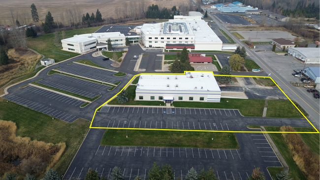
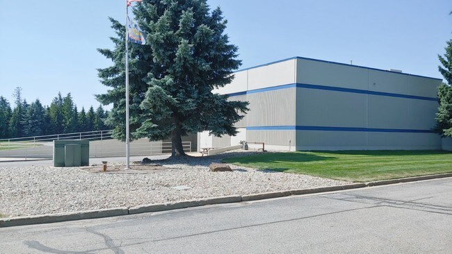
Property Record
35 Litehouse Dr, Kootenai, ID 83840

Property Detail
35 Litehouse Dr
RPK00-000-029100A
2-57N-2W TAX 46 TIMBERSLED/PERCUSSIONAIRE CORP
Industrialgeneral
Bonner
B and X Area of moderate flood hazard, usually the area between the limits of the 100-year and 500-year floods.
Idaho
2025
11.97 AC
2025
Bonner
950203
Coeur D'Alene
155,334 SF
Sandpoint, ID
NEARBY LISTINGS FOR SALE OR LEASE
-
-
View all Kootenai listings for sale on LoopNet.com
DEMOGRAPHICS near 35 Litehouse Dr
1 mile
3 mile
5 mile
2024 Total Population
3,336
11,756
19,205
2029 Population
3,739
13,064
21,290
Pop Growth 2024-2029
+ 12.08%
+ 11.13%
+ 10.86%
Average Age
41
42
43
2024 Total Households
1,324
4,942
8,038
HH Growth 2024-2029
+ 11.71%
+ 10.72%
+ 10.51%
Median Household Inc
$69,632
$68,052
$70,643
Avg Household Size
2.50
2.30
2.30
2024 Avg HH Vehicles
2.00
2.00
2.00
Median Home Value
$411,783
$448,257
$497,744
Median Year Built
2001
1993
1992
Nearby Places
Map Layers
Map Styles
 Street
 Aerial
Transit
 Traffic
 Biking
Places
Listings with unknown addresses are not visible on the map
- Restaurants
- Banks
- Shops
- Fitness
- Groceries
PUBLIC TRANSPORTATION
COMMUTER RAIL
Sandpoint Amtrak (Empire Builder - Amtrak)
Drive
Walk
Distance
Sandpoint Amtrak (Empire Builder - Amtrak)
7 min
3.9 mi
Freight Ports
Port of Everett
Drive
Walk
Distance
Port of Everett
434 min
376.5 mi
SALE & LEASE HISTORY
LISTING DATE
SALE/LEASE

Sep 20, 2019
For Sale
Dec 03, 2020
For Sale
Dec 03, 2020
For Lease
Nearby Properties
Address
Land Use
TOTAL SIZE
Lot Size
Zoning
Address
Land Use
TOTAL SIZE
Lot Size
Zoning
54,573 SF
0.75 AC
Address
Land Use
TOTAL SIZE
Lot Size
Zoning
24,639 SF
3 AC
Address
Land Use
TOTAL SIZE
Lot Size
Zoning
66,673 SF
3.17 AC
Address
Land Use
TOTAL SIZE
Lot Size
Zoning
49,500 SF
16.53 AC
Address
Land Use
TOTAL SIZE
Lot Size
Zoning
4,413 SF
4.79 AC
Address
Land Use
TOTAL SIZE
Lot Size
Zoning
4,512 SF
3.90 AC
Address
Land Use
TOTAL SIZE
Lot Size
Zoning
156,891 SF
14.84 AC
Address
Land Use
TOTAL SIZE
Lot Size
Zoning
29,154 SF
3.80 AC
Address
Land Use
TOTAL SIZE
Lot Size
Zoning
92,969 SF
15.72 AC
Address
Land Use
TOTAL SIZE
Lot Size
Zoning
57,611 SF
2.37 AC
Address
Land Use
TOTAL SIZE
Lot Size
Zoning
4,907 SF
5.04 AC
R-5
Address
Land Use
TOTAL SIZE
Lot Size
Zoning
53,580 SF
5.63 AC
Address
Land Use
TOTAL SIZE
Lot Size
Zoning
106,375 SF
11.87 AC
Address
Land Use
TOTAL SIZE
Lot Size
Zoning
38,980 SF
2.71 AC
Address
Land Use
TOTAL SIZE
Lot Size
Zoning
88,699 SF
6.93 AC
Address
Land Use
TOTAL SIZE
Lot Size
Zoning
16,000 SF
2.32 AC
Address
Land Use
TOTAL SIZE
Lot Size
Zoning
20,396 SF
1.40 AC
Address
Land Use
TOTAL SIZE
Lot Size
Zoning
29,910 SF
2.96 AC
Address
Land Use
TOTAL SIZE
Lot Size
Zoning
33,287 SF
8.05 AC
Address
Land Use
TOTAL SIZE
Lot Size
Zoning
0.83 AC
Address
Land Use
TOTAL SIZE
Lot Size
Zoning
26,966 SF
2.69 AC
Address
Land Use
TOTAL SIZE
Lot Size
Zoning
92,969 SF
6.74 AC
Address
Land Use
TOTAL SIZE
Lot Size
Zoning
10,176 SF
1.14 AC
Address
Land Use
TOTAL SIZE
Lot Size
Zoning
10,176 SF
1.06 AC
Address
Land Use
TOTAL SIZE
Lot Size
Zoning
20,720 SF
2.86 AC
Address
Land Use
TOTAL SIZE
Lot Size
Zoning
3,540 SF
4 AC
Address
Land Use
TOTAL SIZE
Lot Size
Zoning
26,220 SF
1 AC
Address
Land Use
TOTAL SIZE
Lot Size
Zoning
1,633 SF
21.25 AC
Address
Land Use
TOTAL SIZE
Lot Size
Zoning
10.53 AC
R-5
The World's #1 Commercial Real Estate Marketplace
Connect with us
© 2026 CoStar Group
The information above has been obtained from sources believed reliable. While we do not doubt its accuracy we have not verified it and make no guarantee, warranty or representation about it. It is your responsibility to independently confirm its accuracy and completeness. Any projections, opinions, assumptions, or estimates used are for example only and do not represent the current or future performance of the property. The value of this transaction to you depends on tax and other factors which should be evaluated by your tax, financial, and legal advisors. You and your advisors should conduct a careful, independent investigation of the property to determine to your satisfaction the suitability of the property for your needs.