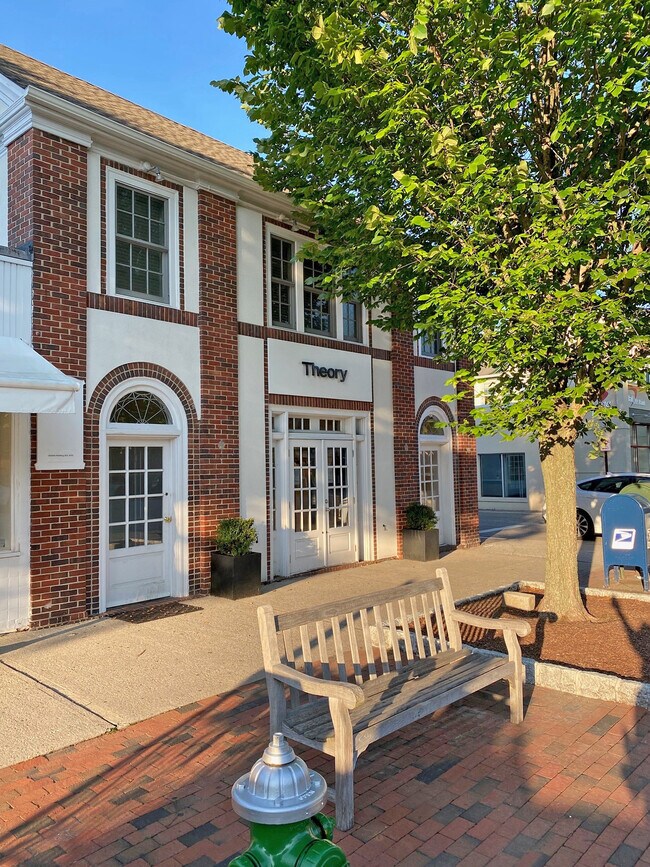
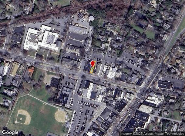
Property Record
52 Newtown Ln, East Hampton, NY 11937
NEARBY LISTINGS FOR SALE OR LEASE
Property Detail
52 Newtown Ln
Nassau County-Suffolk County, NY
NORMAN BARNS WEATHERELL&ORS NEWTOWN LA J REED TC-260
0301-003-00-01-00-003-000
Suffolk
Commercialbuilding
New York
X
3
36103C0558H
0.05 AC
2024
Eastern Suffolk
2024
Long Island (New York)
200901
DEMOGRAPHICS near 52 Newtown Ln
1 Mile
3 Mile
5 Mile
2024 Total Population
4,887
16,946
29,689
2029 Population
5,125
17,870
31,092
Pop Growth 2024-2029
+ 4.87%
+ 5.45%
+ 4.73%
Average Age
44
44
44
2024 Total Households
1,906
6,528
11,373
HH Growth 2024-2029
+ 5.30%
+ 5.64%
+ 4.81%
Median Household Inc
$113,631
$126,239
$130,514
Avg Household Size
2.60
2.60
2.60
2024 Avg HH Vehicles
2.00
2.00
2.00
Median Home Value
$1,099,679
$1,046,499
$1,002,954
Median Year Built
1967
1979
1981
Nearby Places
Map Layers
Map Styles
 Street
 Aerial
- Restaurants
- Banks
- Shops
- Fitness
- Groceries
PUBLIC TRANSPORTATION
COMMUTER RAIL
East Hampton Station (Montauk Branch - Long Island Rail Road)
DRIVE
WALK
Distance
East Hampton Station (Montauk Branch - Long Island Rail Road)
1 min
9 min
0.4 mi
Amagansett Station (Montauk Branch - Long Island Rail Road)
DRIVE
WALK
Distance
Amagansett Station (Montauk Branch - Long Island Rail Road)
8 min
3.4 mi
Freight Ports
Port of New Haven
DRIVE
WALK
Distance
Port of New Haven
200 min
89.2 mi
SALE & LEASE HISTORY
LISTING DATE
SALE/LEASE

Nov 03, 2021
For Lease
Jun 13, 2019
For Lease
Nearby Properties
Address
Land Use
TOTAL SIZE
Lot Size
Zoning
Address
Land Use
TOTAL SIZE
Lot Size
Zoning
2,240 SF
19.46 AC
R40
Address
Land Use
TOTAL SIZE
Lot Size
Zoning
4,132 SF
1.08 AC
R40
Address
Land Use
TOTAL SIZE
Lot Size
Zoning
3,298 SF
0.18 AC
VILLA
Address
Land Use
TOTAL SIZE
Lot Size
Zoning
4,718 SF
1.09 AC
R20
Address
Land Use
TOTAL SIZE
Lot Size
Zoning
53.67 AC
Address
Land Use
TOTAL SIZE
Lot Size
Zoning
3.01 AC
Address
Land Use
TOTAL SIZE
Lot Size
Zoning
17.58 AC
Address
Land Use
TOTAL SIZE
Lot Size
Zoning
1.08 AC
VILLA
Address
Land Use
TOTAL SIZE
Lot Size
Zoning
2,196 SF
0.26 AC
B2
Address
Land Use
TOTAL SIZE
Lot Size
Zoning
2,039 SF
0.29 AC
HO
Address
Land Use
TOTAL SIZE
Lot Size
Zoning
Address
Land Use
TOTAL SIZE
Lot Size
Zoning
0.42 AC
B2
Address
Land Use
TOTAL SIZE
Lot Size
Zoning
0.77 AC
R80
Address
Land Use
TOTAL SIZE
Lot Size
Zoning
Address
Land Use
TOTAL SIZE
Lot Size
Zoning
0.50 AC
R20
Address
Land Use
TOTAL SIZE
Lot Size
Zoning
Address
Land Use
TOTAL SIZE
Lot Size
Zoning
8.10 AC
Address
Land Use
TOTAL SIZE
Lot Size
Zoning
2.10 AC
Address
Land Use
TOTAL SIZE
Lot Size
Zoning
0.82 AC
BD
Address
Land Use
TOTAL SIZE
Lot Size
Zoning
Address
Land Use
TOTAL SIZE
Lot Size
Zoning
0.03 AC
B2
Address
Land Use
TOTAL SIZE
Lot Size
Zoning
Address
Land Use
TOTAL SIZE
Lot Size
Zoning
4.38 AC
Address
Land Use
TOTAL SIZE
Lot Size
Zoning
79.86 AC
Address
Land Use
TOTAL SIZE
Lot Size
Zoning
0.08 AC
B2
Address
Land Use
TOTAL SIZE
Lot Size
Zoning
1.50 AC
Address
Land Use
TOTAL SIZE
Lot Size
Zoning
13.89 AC
Address
Land Use
TOTAL SIZE
Lot Size
Zoning
1.38 AC
Address
Land Use
TOTAL SIZE
Lot Size
Zoning
4.69 AC
Address
Land Use
TOTAL SIZE
Lot Size
Zoning
9.50 AC
The World's #1 Commercial Real Estate Marketplace
Connect with us
© 2025 CoStar Group
The information above has been obtained from sources believed reliable. While we do not doubt its accuracy we have not verified it and make no guarantee, warranty or representation about it. It is your responsibility to independently confirm its accuracy and completeness. Any projections, opinions, assumptions, or estimates used are for example only and do not represent the current or future performance of the property. The value of this transaction to you depends on tax and other factors which should be evaluated by your tax, financial, and legal advisors. You and your advisors should conduct a careful, independent investigation of the property to determine to your satisfaction the suitability of the property for your needs.