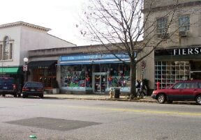
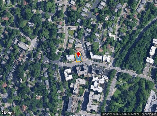
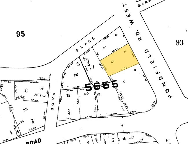
Property Record
52 Pondfield Rd W, Bronxville, NY 10708
NEARBY LISTINGS FOR SALE OR LEASE
-
-
-
-
-
-
-
-
-
-
-
-
-
-
-
-
-
-
No Photo
-
-
-
-
-
-
View all Bronxville listings for sale on LoopNet.com
Property Detail
52 Pondfield Rd W
1800-005-000-05655-000-0009
Westchester
Storesoffices
New York
X
9.000
36119C0329F
0.13 AC
2025
Southwest
2024
Westchester/So Connecticut
002202
New York-Jersey City-White Plains, NY-NJ
3,510 SF
DEMOGRAPHICS near 52 Pondfield Rd W
1 mile
3 mile
5 mile
2024 Total Population
27,316
259,858
647,201
2029 Population
26,983
252,045
619,729
Pop Growth 2024-2029
(1.22%)
(3.01%)
(4.24%)
Average Age
45
41
41
2024 Total Households
11,963
97,759
240,350
HH Growth 2024-2029
(1.35%)
(3.10%)
(4.43%)
Median Household Inc
$107,659
$85,871
$79,794
Avg Household Size
2.20
2.50
2.60
2024 Avg HH Vehicles
1.00
1.00
1.00
Median Home Value
$514,831
$531,774
$585,052
Median Year Built
1953
1951
1953
Nearby Places
Map Layers
Map Styles
 Street
 Aerial
Transit
 Traffic
 Biking
Places
Listings with unknown addresses are not visible on the map
- Restaurants
- Banks
- Shops
- Fitness
- Groceries
PUBLIC TRANSPORTATION
COMMUTER RAIL
Bronxville Station (Harlem Line - Metro-North Commuter Railroad Company (Metro-North))
Drive
Walk
Distance
Bronxville Station (Harlem Line - Metro-North Commuter Railroad Company (Metro-North))
1 min
12 min
0.4 mi
Tuckahoe Station (Harlem Line - Metro-North Commuter Railroad Company (Metro-North))
Drive
Walk
Distance
Tuckahoe Station (Harlem Line - Metro-North Commuter Railroad Company (Metro-North))
2 min
19 min
1.0 mi
AIRPORT
Westchester County
Drive
Walk
Distance
Westchester County
25 min
15.6 mi
LaGuardia
Drive
Walk
Distance
LaGuardia
30 min
17.0 mi
John F Kennedy International
Drive
Walk
Distance
John F Kennedy International
37 min
24.8 mi
Freight Ports
NY - Red Hook Container Terminal
Drive
Walk
Distance
NY - Red Hook Container Terminal
43 min
25.2 mi
Nearby Properties
Address
Land Use
TOTAL SIZE
Lot Size
Zoning
Address
Land Use
TOTAL SIZE
Lot Size
Zoning
18,000 SF
13.85 AC
A
Address
Land Use
TOTAL SIZE
Lot Size
Zoning
201,590 SF
4.13 AC
BA
Address
Land Use
TOTAL SIZE
Lot Size
Zoning
301,156 SF
13.94 AC
A
Address
Land Use
TOTAL SIZE
Lot Size
Zoning
70,737 SF
1.67 AC
BB
Address
Land Use
TOTAL SIZE
Lot Size
Zoning
64,165 SF
3.24 AC
B
Address
Land Use
TOTAL SIZE
Lot Size
Zoning
5,170 SF
9.08 AC
B
Address
Land Use
TOTAL SIZE
Lot Size
Zoning
130,211 SF
1.80 AC
D
Address
Land Use
TOTAL SIZE
Lot Size
Zoning
113,690 SF
1.87 AC
D
Address
Land Use
TOTAL SIZE
Lot Size
Zoning
7,855 SF
1.10 AC
C
Address
Land Use
TOTAL SIZE
Lot Size
Zoning
83,652 SF
1.88 AC
D
Address
Land Use
TOTAL SIZE
Lot Size
Zoning
5.50 AC
R-20
Address
Land Use
TOTAL SIZE
Lot Size
Zoning
Address
Land Use
TOTAL SIZE
Lot Size
Zoning
56,525 SF
0.57 AC
BA
Address
Land Use
TOTAL SIZE
Lot Size
Zoning
51,773 SF
0.72 AC
D
Address
Land Use
TOTAL SIZE
Lot Size
Zoning
36,413 SF
0.89 AC
A
Address
Land Use
TOTAL SIZE
Lot Size
Zoning
12,396 SF
1.68 AC
AAA
Address
Land Use
TOTAL SIZE
Lot Size
Zoning
53,982 SF
1.11 AC
D
Address
Land Use
TOTAL SIZE
Lot Size
Zoning
34,560 SF
0.28 AC
BA
Address
Land Use
TOTAL SIZE
Lot Size
Zoning
96,420 SF
4.89 AC
RB1
Address
Land Use
TOTAL SIZE
Lot Size
Zoning
53,982 SF
0.98 AC
D
Address
Land Use
TOTAL SIZE
Lot Size
Zoning
23,116 SF
1.82 AC
C
Address
Land Use
TOTAL SIZE
Lot Size
Zoning
57,180 SF
1.42 AC
D
Address
Land Use
TOTAL SIZE
Lot Size
Zoning
Address
Land Use
TOTAL SIZE
Lot Size
Zoning
7,850 SF
0.89 AC
AAA
Address
Land Use
TOTAL SIZE
Lot Size
Zoning
7,771 SF
1.21 AC
A
Address
Land Use
TOTAL SIZE
Lot Size
Zoning
9,800 SF
1.96 AC
AA
Address
Land Use
TOTAL SIZE
Lot Size
Zoning
162.42 AC
T
Address
Land Use
TOTAL SIZE
Lot Size
Zoning
1,658 SF
3.28 AC
A
Address
Land Use
TOTAL SIZE
Lot Size
Zoning
36,000 SF
0.28 AC
BA
Address
Land Use
TOTAL SIZE
Lot Size
Zoning
47,830 SF
0.60 AC
B
The World's #1 Commercial Real Estate Marketplace
Connect with us
© 2026 CoStar Group
The information above has been obtained from sources believed reliable. While we do not doubt its accuracy we have not verified it and make no guarantee, warranty or representation about it. It is your responsibility to independently confirm its accuracy and completeness. Any projections, opinions, assumptions, or estimates used are for example only and do not represent the current or future performance of the property. The value of this transaction to you depends on tax and other factors which should be evaluated by your tax, financial, and legal advisors. You and your advisors should conduct a careful, independent investigation of the property to determine to your satisfaction the suitability of the property for your needs.