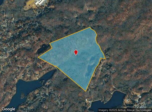
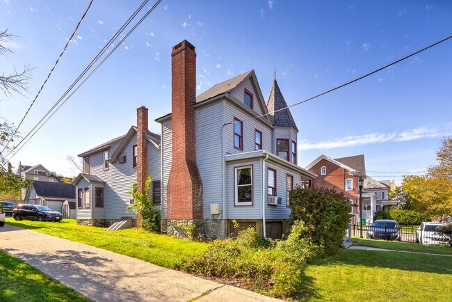
Property Record
52 Trinity St, Newton, NJ 07860

NEARBY LISTINGS FOR SALE OR LEASE
Property Detail
52 Trinity St
15-00008-05-00005
Sussex
Farms
New Jersey
X
6
34037C0311E
112.39 AC
2024
Sussex County
2025
Northern New Jersey
373500
Newark, NJ-PA
2,048 SF
DEMOGRAPHICS near 52 Trinity St
1 Mile
3 Mile
5 Mile
2024 Total Population
6,896
14,867
27,417
2029 Population
6,947
14,975
27,631
Pop Growth 2024-2029
+ 0.74%
+ 0.73%
+ 0.78%
Average Age
42
44
44
2024 Total Households
2,841
5,869
10,450
HH Growth 2024-2029
+ 0.84%
+ 0.82%
+ 0.84%
Median Household Inc
$67,106
$84,920
$104,822
Avg Household Size
2.30
2.40
2.50
2024 Avg HH Vehicles
2.00
2.00
2.00
Median Home Value
$248,970
$293,909
$341,952
Median Year Built
1954
1971
1971
Nearby Places
Map Layers
Map Styles
 Street
 Aerial
- Restaurants
- Banks
- Shops
- Fitness
- Groceries
PUBLIC TRANSPORTATION
COMMUTER RAIL
Mount Olive (Montclair-Boonton Line - NJ Transit Commuter Rail (NJ Transit), Morris & Essex Morristown Line - NJ Transit Commuter Rail (NJ Transit))
DRIVE
WALK
Distance
Mount Olive (Montclair-Boonton Line - NJ Transit Commuter Rail (NJ Transit), Morris & Essex Morristown Line - NJ Transit Commuter Rail (NJ Transit))
16 min
10.0 mi
Freight Ports
Maher Terminal
DRIVE
WALK
Distance
Maher Terminal
67 min
50.1 mi
SALE & LEASE HISTORY
LISTING DATE
SALE/LEASE

Jan 20, 2022
For Sale
Nearby Properties
Address
Land Use
TOTAL SIZE
Lot Size
Zoning
Address
Land Use
TOTAL SIZE
Lot Size
Zoning
47,400 SF
71 AC
SD-4
Address
Land Use
TOTAL SIZE
Lot Size
Zoning
2.09 AC
T-5
Address
Land Use
TOTAL SIZE
Lot Size
Zoning
26,185 SF
552.92 AC
I/A
Address
Land Use
TOTAL SIZE
Lot Size
Zoning
10 AC
RR
Address
Land Use
TOTAL SIZE
Lot Size
Zoning
45,532 SF
10.31 AC
R1
Address
Land Use
TOTAL SIZE
Lot Size
Zoning
58,607 SF
26.13 AC
RR
Address
Land Use
TOTAL SIZE
Lot Size
Zoning
76,409 SF
29.80 AC
R2
Address
Land Use
TOTAL SIZE
Lot Size
Zoning
3,280 SF
17.30 AC
MF
Address
Land Use
TOTAL SIZE
Lot Size
Zoning
11,843 SF
9.68 AC
RR
Address
Land Use
TOTAL SIZE
Lot Size
Zoning
38,004 SF
3.08 AC
R2
Address
Land Use
TOTAL SIZE
Lot Size
Zoning
528 SF
10.85 AC
RR
Address
Land Use
TOTAL SIZE
Lot Size
Zoning
5 AC
R1
Address
Land Use
TOTAL SIZE
Lot Size
Zoning
14,967 SF
82.85 AC
RR
Address
Land Use
TOTAL SIZE
Lot Size
Zoning
42,036 SF
2.94 AC
C-1
Address
Land Use
TOTAL SIZE
Lot Size
Zoning
22,528 SF
7.50 AC
RR
Address
Land Use
TOTAL SIZE
Lot Size
Zoning
23,812 SF
2.29 AC
C-1
Address
Land Use
TOTAL SIZE
Lot Size
Zoning
10,940 SF
152.42 AC
CR
Address
Land Use
TOTAL SIZE
Lot Size
Zoning
23,776 SF
190.85 AC
R1
Address
Land Use
TOTAL SIZE
Lot Size
Zoning
70.27 AC
E-D
Address
Land Use
TOTAL SIZE
Lot Size
Zoning
1,100 SF
1.71 AC
SD-4
Address
Land Use
TOTAL SIZE
Lot Size
Zoning
1.73 AC
SD-4
Address
Land Use
TOTAL SIZE
Lot Size
Zoning
38,654 SF
10.39 AC
R1
Address
Land Use
TOTAL SIZE
Lot Size
Zoning
10 AC
R1
Address
Land Use
TOTAL SIZE
Lot Size
Zoning
10,430 SF
8.74 AC
Address
Land Use
TOTAL SIZE
Lot Size
Zoning
2,319 SF
3.70 AC
T-4
Address
Land Use
TOTAL SIZE
Lot Size
Zoning
17,093 SF
1.38 AC
C-1
Address
Land Use
TOTAL SIZE
Lot Size
Zoning
8,745 SF
42.26 AC
ED
Address
Land Use
TOTAL SIZE
Lot Size
Zoning
56,500 SF
6.55 AC
T-4
Address
Land Use
TOTAL SIZE
Lot Size
Zoning
12,555 SF
1.50 AC
R1
Address
Land Use
TOTAL SIZE
Lot Size
Zoning
35,900 SF
5.30 AC
R1
The World's #1 Commercial Real Estate Marketplace
Connect with us
© 2025 CoStar Group
The information above has been obtained from sources believed reliable. While we do not doubt its accuracy we have not verified it and make no guarantee, warranty or representation about it. It is your responsibility to independently confirm its accuracy and completeness. Any projections, opinions, assumptions, or estimates used are for example only and do not represent the current or future performance of the property. The value of this transaction to you depends on tax and other factors which should be evaluated by your tax, financial, and legal advisors. You and your advisors should conduct a careful, independent investigation of the property to determine to your satisfaction the suitability of the property for your needs.