Property Record
52 Us Highway 52 At E Us Highway 52 Rd, Utica, IL 61373
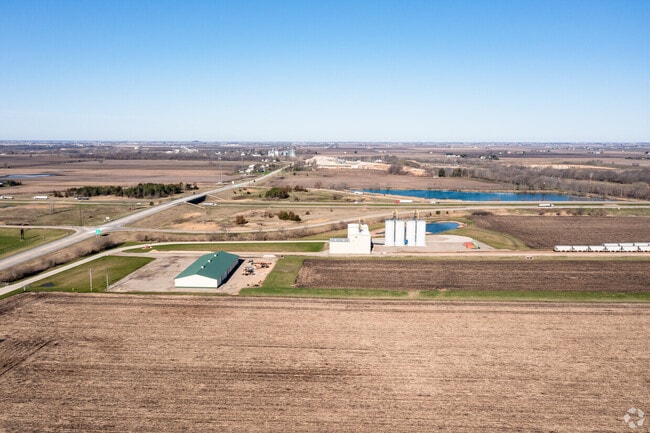
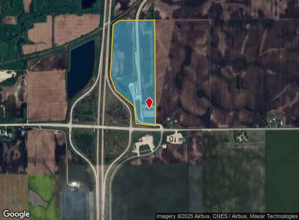
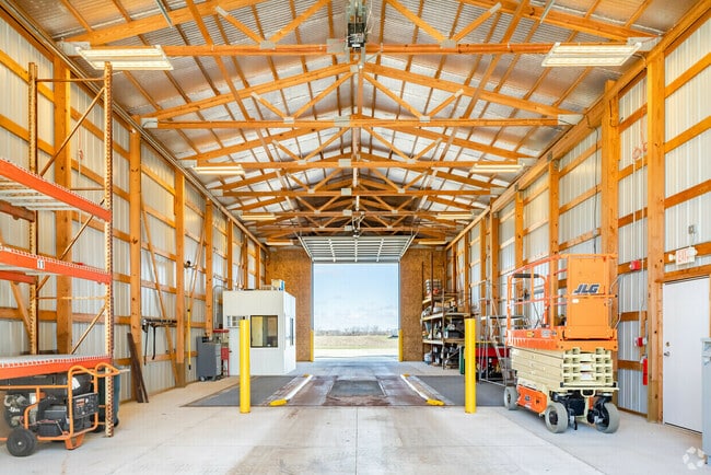
This Property Is For Sale
NEARBY LISTINGS FOR SALE OR LEASE
-
-
View all Utica listings for sale on LoopNet.com
Property Detail
52 Us Highway 52 At E Us Highway 52 Rd
07-30-300000
W 65.5 AC SW 1/4 EX 15.55 AC TO NEW HWY 51 SEC 30-35-2
Farms
La Salle
X
Illinois
17099C0350F
49.95 AC
2024
I-39 Cor/LaSalle Cnty
2024
Chicago
962200
Ottawa, IL
2,400 SF
DEMOGRAPHICS near 52 Us Highway 52 At E Us Highway 52 Rd
1 Mile
3 Mile
5 Mile
2024 Total Population
23
691
1,283
2029 Population
22
666
1,243
Pop Growth 2024-2029
(4.35%)
(3.62%)
(3.12%)
Average Age
46
45
45
2024 Total Households
9
278
505
HH Growth 2024-2029
0.00%
(3.60%)
(3.17%)
Median Household Inc
$137,500
$122,082
$113,958
Avg Household Size
2.10
2.50
2.50
2024 Avg HH Vehicles
3.00
3.00
2.00
Median Home Value
$199,999
$250,925
$248,469
Median Year Built
1962
1962
1962
Nearby Places
Map Layers
Map Styles
 Street
 Aerial
- Restaurants
- Banks
- Shops
- Fitness
- Groceries
PUBLIC TRANSPORTATION
COMMUTER RAIL
Mendota Amtrak Station (Carl Sandburg - Amtrak, Illinois Zephyr - Amtrak, Southwest Chief - Amtrak)
DRIVE
WALK
Distance
Mendota Amtrak Station (Carl Sandburg - Amtrak, Illinois Zephyr - Amtrak, Southwest Chief - Amtrak)
12 min
9.4 mi
Freight Ports
Port Milwaukee
DRIVE
WALK
Distance
Port Milwaukee
166 min
147.2 mi
Nearby Properties
Address
Land Use
TOTAL SIZE
Lot Size
Zoning
Address
Land Use
TOTAL SIZE
Lot Size
Zoning
114.31 AC
Address
Land Use
TOTAL SIZE
Lot Size
Zoning
1,368 SF
8.35 AC
Address
Land Use
TOTAL SIZE
Lot Size
Zoning
2,419 SF
2 AC
Address
Land Use
TOTAL SIZE
Lot Size
Zoning
73.71 AC
Address
Land Use
TOTAL SIZE
Lot Size
Zoning
576 SF
80 AC
Address
Land Use
TOTAL SIZE
Lot Size
Zoning
14.22 AC
Address
Land Use
TOTAL SIZE
Lot Size
Zoning
7.58 AC
Address
Land Use
TOTAL SIZE
Lot Size
Zoning
1,500 SF
66.18 AC
Address
Land Use
TOTAL SIZE
Lot Size
Zoning
2,582 SF
16.14 AC
Address
Land Use
TOTAL SIZE
Lot Size
Zoning
127 AC
Address
Land Use
TOTAL SIZE
Lot Size
Zoning
10,792 SF
4.14 AC
Address
Land Use
TOTAL SIZE
Lot Size
Zoning
3,228 SF
3.50 AC
Address
Land Use
TOTAL SIZE
Lot Size
Zoning
9,840 SF
11.05 AC
Address
Land Use
TOTAL SIZE
Lot Size
Zoning
158 AC
Address
Land Use
TOTAL SIZE
Lot Size
Zoning
1,274 SF
103.59 AC
Address
Land Use
TOTAL SIZE
Lot Size
Zoning
1,296 SF
2 AC
Address
Land Use
TOTAL SIZE
Lot Size
Zoning
128.04 AC
Address
Land Use
TOTAL SIZE
Lot Size
Zoning
82.46 AC
Address
Land Use
TOTAL SIZE
Lot Size
Zoning
137.14 AC
Address
Land Use
TOTAL SIZE
Lot Size
Zoning
690 SF
1.33 AC
Address
Land Use
TOTAL SIZE
Lot Size
Zoning
1,920 SF
73.61 AC
Address
Land Use
TOTAL SIZE
Lot Size
Zoning
191.18 AC
Address
Land Use
TOTAL SIZE
Lot Size
Zoning
1,626 SF
79.40 AC
Address
Land Use
TOTAL SIZE
Lot Size
Zoning
2,328 SF
13.62 AC
Address
Land Use
TOTAL SIZE
Lot Size
Zoning
2,268 SF
157.53 AC
Address
Land Use
TOTAL SIZE
Lot Size
Zoning
1,846 SF
80 AC
Address
Land Use
TOTAL SIZE
Lot Size
Zoning
2,769 SF
6.17 AC
Address
Land Use
TOTAL SIZE
Lot Size
Zoning
1,846 SF
79 AC
Address
Land Use
TOTAL SIZE
Lot Size
Zoning
2,056 SF
50 AC
The World's #1 Commercial Real Estate Marketplace
Connect with us
© 2026 CoStar Group
The information above has been obtained from sources believed reliable. While we do not doubt its accuracy we have not verified it and make no guarantee, warranty or representation about it. It is your responsibility to independently confirm its accuracy and completeness. Any projections, opinions, assumptions, or estimates used are for example only and do not represent the current or future performance of the property. The value of this transaction to you depends on tax and other factors which should be evaluated by your tax, financial, and legal advisors. You and your advisors should conduct a careful, independent investigation of the property to determine to your satisfaction the suitability of the property for your needs.