Property Record
52 W Main St, Brookfield, MA 01506

Save to a Folder
{{folder.Name}}
{{folder.ListingIds.length}} Properties
{{folder.ListingIds.length}} Property
Create a New Folder
Property Detail
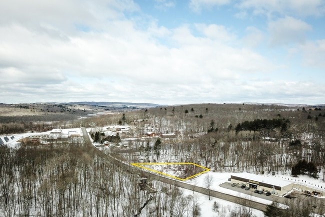
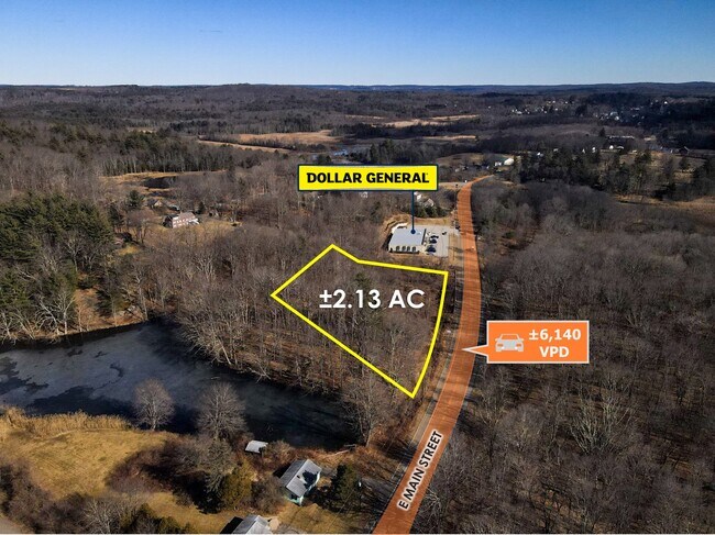
52 W Main St
BROO-000007B-000000-000240
WORCESTER
Storebuilding
Massachusetts
RR
240
2025
1.89 AC
2025
Outlying Worcester
760100
Boston
9,283 SF
Worcester, MA
NEARBY LISTINGS FOR SALE OR LEASE
-
-
View all Brookfield listings for sale on LoopNet.com
DEMOGRAPHICS near 52 W Main St
1 mile
3 mile
5 mile
2025 Total Population
388
6,466
18,783
2030 Population
390
6,618
19,343
Pop Growth 2025-2030
+ 0.52%
+ 2.35%
+ 2.98%
Average Age
43
46
44
2025 Total Households
151
2,679
7,652
HH Growth 2025-2030
+ 0.66%
+ 2.54%
+ 3.07%
Median Household Inc
$67,500
$73,623
$80,688
Avg Household Size
2.50
2.30
2.40
2025 Avg HH Vehicles
2.00
2.00
2.00
Median Home Value
$348,958
$365,231
$383,142
Median Year Built
1947
1969
1972
Nearby Places
Map Layers
Map Styles
 Street
 Aerial
Layers
 Traffic
 Biking
Places
Listings with unknown addresses are not visible on the map
- Restaurants
- Banks
- Shops
- Fitness
- Groceries
PUBLIC TRANSPORTATION
AIRPORT
Worcester Regional
Drive
Walk
Distance
Worcester Regional
37 min
17.4 mi
Bradley International
Drive
Walk
Distance
Bradley International
77 min
45.4 mi
Freight Ports
Port of Davisville, RI
Drive
Walk
Distance
Port of Davisville, RI
112 min
77.5 mi
SALE & LEASE HISTORY
LISTING DATE
SALE/LEASE

Mar 22, 2018
For Sale
Jul 12, 2018
For Sale
Feb 22, 2023
For Sale
Nearby Properties
Address
Land Use
TOTAL SIZE
Lot Size
Zoning
Address
Land Use
TOTAL SIZE
Lot Size
Zoning
76,000 SF
20.83 AC
RR
Address
Land Use
TOTAL SIZE
Lot Size
Zoning
104,040 SF
17.14 AC
V
Address
Land Use
TOTAL SIZE
Lot Size
Zoning
20,700 SF
1.37 AC
BA
Address
Land Use
TOTAL SIZE
Lot Size
Zoning
23,918 SF
4.97 AC
CD
Address
Land Use
TOTAL SIZE
Lot Size
Zoning
34,368 SF
12.50 AC
RR
Address
Land Use
TOTAL SIZE
Lot Size
Zoning
640 SF
42 AC
RR
Address
Land Use
TOTAL SIZE
Lot Size
Zoning
18,744 SF
5.80 AC
GD
Address
Land Use
TOTAL SIZE
Lot Size
Zoning
1,989 SF
4.06 AC
GD
Address
Land Use
TOTAL SIZE
Lot Size
Zoning
46,980 SF
15.07 AC
GD
Address
Land Use
TOTAL SIZE
Lot Size
Zoning
42,853 SF
0.64 AC
GD
Address
Land Use
TOTAL SIZE
Lot Size
Zoning
522.88 AC
66
Address
Land Use
TOTAL SIZE
Lot Size
Zoning
499 AC
RR
Address
Land Use
TOTAL SIZE
Lot Size
Zoning
700 SF
7 AC
CD
Address
Land Use
TOTAL SIZE
Lot Size
Zoning
17,378 SF
0.37 AC
GD
Address
Land Use
TOTAL SIZE
Lot Size
Zoning
10,986 SF
0.72 AC
V
Address
Land Use
TOTAL SIZE
Lot Size
Zoning
3,161 SF
1 AC
GD
Address
Land Use
TOTAL SIZE
Lot Size
Zoning
57,094 SF
4.68 AC
GD
Address
Land Use
TOTAL SIZE
Lot Size
Zoning
9,836 SF
0.73 AC
GD
Address
Land Use
TOTAL SIZE
Lot Size
Zoning
353.60 AC
RR
Address
Land Use
TOTAL SIZE
Lot Size
Zoning
351.25 AC
RR
Address
Land Use
TOTAL SIZE
Lot Size
Zoning
11,727 SF
0.44 AC
V
Address
Land Use
TOTAL SIZE
Lot Size
Zoning
76.76 AC
C
Address
Land Use
TOTAL SIZE
Lot Size
Zoning
12,000 SF
13.23 AC
C
Address
Land Use
TOTAL SIZE
Lot Size
Zoning
0.21 AC
GD
Address
Land Use
TOTAL SIZE
Lot Size
Zoning
4,196 SF
3.20 AC
RR
Address
Land Use
TOTAL SIZE
Lot Size
Zoning
276.77 AC
RR
Address
Land Use
TOTAL SIZE
Lot Size
Zoning
67.18 AC
BB
Address
Land Use
TOTAL SIZE
Lot Size
Zoning
41,400 SF
3.65 AC
GD
Address
Land Use
TOTAL SIZE
Lot Size
Zoning
11,232 SF
6.74 AC
RR
The World's #1 Commercial Real Estate Marketplace
Connect with us
© 2026 CoStar Group
The information above has been obtained from sources believed reliable. While we do not doubt its accuracy we have not verified it and make no guarantee, warranty or representation about it. It is your responsibility to independently confirm its accuracy and completeness. Any projections, opinions, assumptions, or estimates used are for example only and do not represent the current or future performance of the property. The value of this transaction to you depends on tax and other factors which should be evaluated by your tax, financial, and legal advisors. You and your advisors should conduct a careful, independent investigation of the property to determine to your satisfaction the suitability of the property for your needs.