Property Record
520 3Rd St, Excelsior, MN 55331
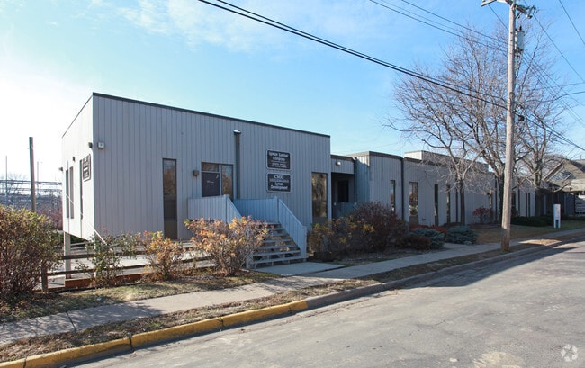
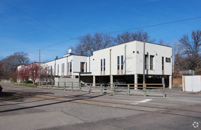
Property Detail
520 3Rd St
Minneapolis-St. Paul-Bloomington, MN-WI
LOT 055 B AUDITORS SUBD. NO. 120 LOTS 55 AND 201 AUD SUBD NO 120 ALSO THAT PART OF LOT 54 AND OF THAT PART OF LOT 50 LYING SELY OF SCHOOL AVE IN SAID AUD SUBD WHICH LIES SWLY OF A T IRREGULAR
34-117-23-14-0058
HENNEPIN
Commercialnec
Minnesota
B and X Area of moderate flood hazard, usually the area between the limits of the 100-year and 500-year floods.
55
2024
0.53 AC
2024
Hennepin County Outlying
027503
Minneapolis/St Paul
NEARBY LISTINGS FOR SALE OR LEASE
DEMOGRAPHICS near 520 3Rd St
1 mile
3 mile
5 mile
2025 Total Population
5,233
34,099
91,959
2030 Population
5,351
34,652
93,116
Pop Growth 2025-2030
+ 2.25%
+ 1.62%
+ 1.26%
Average Age
45
43
43
2025 Total Households
2,244
13,008
35,963
HH Growth 2025-2030
+ 2.23%
+ 1.68%
+ 1.30%
Median Household Inc
$129,986
$151,325
$140,052
Avg Household Size
2.30
2.60
2.50
2025 Avg HH Vehicles
2.00
2.00
2.00
Median Home Value
$824,581
$678,212
$600,052
Median Year Built
1979
1984
1984
Nearby Places
Map Layers
Map Styles
 Street
 Aerial
Transit
 Traffic
 Biking
Places
Listings with unknown addresses are not visible on the map
- Restaurants
- Banks
- Shops
- Fitness
- Groceries
PUBLIC TRANSPORTATION
AIRPORT
Minneapolis-St Paul International/Wold-Chamberlain
Drive
Walk
Distance
Minneapolis-St Paul International/Wold-Chamberlain
31 min
20.9 mi
Nearby Properties
Address
Land Use
TOTAL SIZE
Lot Size
Zoning
Address
Land Use
TOTAL SIZE
Lot Size
Zoning
4.32 AC
Address
Land Use
TOTAL SIZE
Lot Size
Zoning
55,208 SF
49.75 AC
Address
Land Use
TOTAL SIZE
Lot Size
Zoning
122,807 SF
30.62 AC
Address
Land Use
TOTAL SIZE
Lot Size
Zoning
3,073 SF
155.36 AC
Address
Land Use
TOTAL SIZE
Lot Size
Zoning
3.82 AC
Address
Land Use
TOTAL SIZE
Lot Size
Zoning
1.85 AC
Address
Land Use
TOTAL SIZE
Lot Size
Zoning
21.72 AC
Address
Land Use
TOTAL SIZE
Lot Size
Zoning
94,387 SF
14.77 AC
Address
Land Use
TOTAL SIZE
Lot Size
Zoning
7.82 AC
R4
Address
Land Use
TOTAL SIZE
Lot Size
Zoning
17.67 AC
R4
Address
Land Use
TOTAL SIZE
Lot Size
Zoning
9.29 AC
R4
Address
Land Use
TOTAL SIZE
Lot Size
Zoning
Address
Land Use
TOTAL SIZE
Lot Size
Zoning
14.04 AC
R4
Address
Land Use
TOTAL SIZE
Lot Size
Zoning
34,100 SF
12.99 AC
Address
Land Use
TOTAL SIZE
Lot Size
Zoning
301,389 SF
36.47 AC
Address
Land Use
TOTAL SIZE
Lot Size
Zoning
181,405 SF
14.06 AC
Address
Land Use
TOTAL SIZE
Lot Size
Zoning
16.38 AC
Address
Land Use
TOTAL SIZE
Lot Size
Zoning
1,200 SF
62.14 AC
Address
Land Use
TOTAL SIZE
Lot Size
Zoning
88,205 SF
8.91 AC
Address
Land Use
TOTAL SIZE
Lot Size
Zoning
Address
Land Use
TOTAL SIZE
Lot Size
Zoning
131,019 SF
10.06 AC
Address
Land Use
TOTAL SIZE
Lot Size
Zoning
154,674 SF
14.10 AC
Address
Land Use
TOTAL SIZE
Lot Size
Zoning
1.67 AC
Address
Land Use
TOTAL SIZE
Lot Size
Zoning
69,144 SF
13.98 AC
Address
Land Use
TOTAL SIZE
Lot Size
Zoning
6.52 AC
Address
Land Use
TOTAL SIZE
Lot Size
Zoning
12.02 AC
Address
Land Use
TOTAL SIZE
Lot Size
Zoning
3.20 AC
Address
Land Use
TOTAL SIZE
Lot Size
Zoning
29,045 SF
2.98 AC
Address
Land Use
TOTAL SIZE
Lot Size
Zoning
63,239 SF
9.92 AC
Address
Land Use
TOTAL SIZE
Lot Size
Zoning
5.68 AC
The World's #1 Commercial Real Estate Marketplace
Connect with us
© 2026 CoStar Group
The information above has been obtained from sources believed reliable. While we do not doubt its accuracy we have not verified it and make no guarantee, warranty or representation about it. It is your responsibility to independently confirm its accuracy and completeness. Any projections, opinions, assumptions, or estimates used are for example only and do not represent the current or future performance of the property. The value of this transaction to you depends on tax and other factors which should be evaluated by your tax, financial, and legal advisors. You and your advisors should conduct a careful, independent investigation of the property to determine to your satisfaction the suitability of the property for your needs.