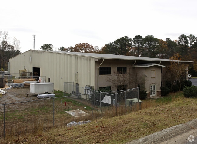
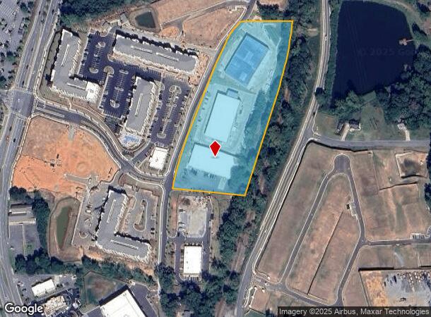
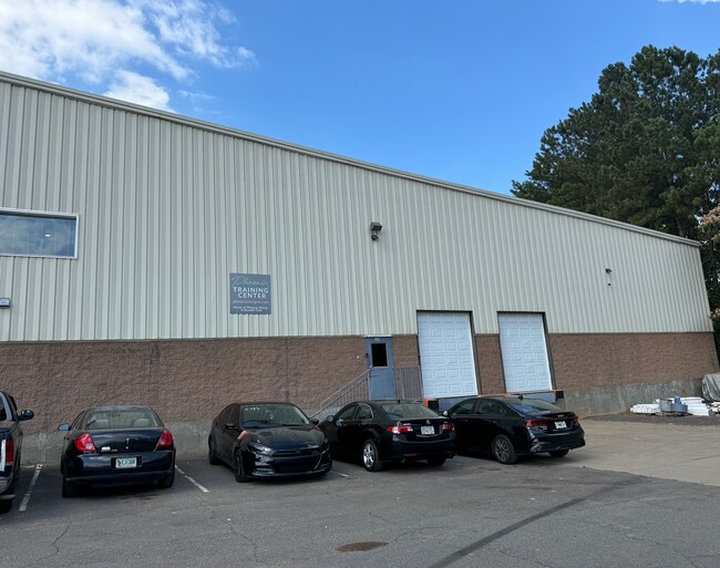
Property Record
500 E Rope Mill Ln, Canton, GA 30115
NEARBY LISTINGS FOR SALE OR LEASE
Property Detail
500 E Rope Mill Ln
015N15-00000-074-000-0000
LL 592 15TH D
Industrialgeneral
Cherokee
X
Georgia
13057C0244E
6.61 AC
2025
Woodstock/Canton
2025
Atlanta
090703
Atlanta-Sandy Springs-Roswell, GA
84,370 SF
DEMOGRAPHICS near 500 E Rope Mill Ln
1 Mile
3 Mile
5 Mile
2024 Total Population
7,705
51,572
146,764
2029 Population
8,962
59,020
168,004
Pop Growth 2024-2029
+ 16.31%
+ 14.44%
+ 14.47%
Average Age
37
39
40
2024 Total Households
2,931
18,660
53,304
HH Growth 2024-2029
+ 16.51%
+ 14.65%
+ 14.63%
Median Household Inc
$71,032
$93,972
$102,006
Avg Household Size
2.60
2.70
2.70
2024 Avg HH Vehicles
2.00
2.00
2.00
Median Home Value
$330,094
$343,389
$352,072
Median Year Built
2004
2001
2000
Nearby Places
- Restaurants
- Banks
- Shops
- Fitness
- Groceries
SALE & LEASE HISTORY
LISTING DATE
SALE/LEASE

Jul 15, 2024
For Lease
Nearby Properties
Address
Land Use
TOTAL SIZE
Lot Size
Zoning
Address
Land Use
TOTAL SIZE
Lot Size
Zoning
235,863 SF
18.96 AC
HDMFR
Address
Land Use
TOTAL SIZE
Lot Size
Zoning
604,056 SF
25.03 AC
R-40
Address
Land Use
TOTAL SIZE
Lot Size
Zoning
275,118 SF
21.61 AC
R-40
Address
Land Use
TOTAL SIZE
Lot Size
Zoning
349,911 SF
18.11 AC
LI
Address
Land Use
TOTAL SIZE
Lot Size
Zoning
399,085 SF
38.48 AC
LI
Address
Land Use
TOTAL SIZE
Lot Size
Zoning
353,395 SF
29.15 AC
GC
Address
Land Use
TOTAL SIZE
Lot Size
Zoning
157,013 SF
18.53 AC
IN-VIL
Address
Land Use
TOTAL SIZE
Lot Size
Zoning
120,084 SF
25.15 AC
LI
Address
Land Use
TOTAL SIZE
Lot Size
Zoning
328,203 SF
71 AC
R-40
Address
Land Use
TOTAL SIZE
Lot Size
Zoning
145,195 SF
14.47 AC
R-40
Address
Land Use
TOTAL SIZE
Lot Size
Zoning
299,408 SF
15 AC
TND
Address
Land Use
TOTAL SIZE
Lot Size
Zoning
189,456 SF
28.35 AC
NC-TCT
Address
Land Use
TOTAL SIZE
Lot Size
Zoning
186,426 SF
32.52 AC
NC-TCT
Address
Land Use
TOTAL SIZE
Lot Size
Zoning
182,067 SF
23.83 AC
GC
Address
Land Use
TOTAL SIZE
Lot Size
Zoning
134,017 SF
42.78 AC
AG
Address
Land Use
TOTAL SIZE
Lot Size
Zoning
156,752 SF
16.34 AC
NC-TCT
Address
Land Use
TOTAL SIZE
Lot Size
Zoning
52,703 SF
37.65 AC
LI
Address
Land Use
TOTAL SIZE
Lot Size
Zoning
88,795 SF
30.92 AC
DT-CI
Address
Land Use
TOTAL SIZE
Lot Size
Zoning
32,224 SF
2.89 AC
GC
Address
Land Use
TOTAL SIZE
Lot Size
Zoning
107,977 SF
17.26 AC
GC
Address
Land Use
TOTAL SIZE
Lot Size
Zoning
85,343 SF
2.46 AC
GC
Address
Land Use
TOTAL SIZE
Lot Size
Zoning
36,413 SF
2.22 AC
LI
Address
Land Use
TOTAL SIZE
Lot Size
Zoning
90,006 SF
11.63 AC
GC
Address
Land Use
TOTAL SIZE
Lot Size
Zoning
66,439 SF
3.59 AC
GC
Address
Land Use
TOTAL SIZE
Lot Size
Zoning
70,397 SF
13.24 AC
R-20
Address
Land Use
TOTAL SIZE
Lot Size
Zoning
75,398 SF
31 AC
R-40
Address
Land Use
TOTAL SIZE
Lot Size
Zoning
78,987 SF
6.54 AC
GC
Address
Land Use
TOTAL SIZE
Lot Size
Zoning
65,077 SF
8.14 AC
R-40
Address
Land Use
TOTAL SIZE
Lot Size
Zoning
44,397 SF
15.84 AC
GC
Address
Land Use
TOTAL SIZE
Lot Size
Zoning
33,071 SF
1.70 AC
TND
The World's #1 Commercial Real Estate Marketplace
Connect with us
© 2025 CoStar Group
The information above has been obtained from sources believed reliable. While we do not doubt its accuracy we have not verified it and make no guarantee, warranty or representation about it. It is your responsibility to independently confirm its accuracy and completeness. Any projections, opinions, assumptions, or estimates used are for example only and do not represent the current or future performance of the property. The value of this transaction to you depends on tax and other factors which should be evaluated by your tax, financial, and legal advisors. You and your advisors should conduct a careful, independent investigation of the property to determine to your satisfaction the suitability of the property for your needs.