Property Record
520 Forsythe Rd, Bristol, VA 24202

NEARBY LISTINGS FOR SALE OR LEASE
-
-
View all Bristol listings for sale on LoopNet.com
Property Detail
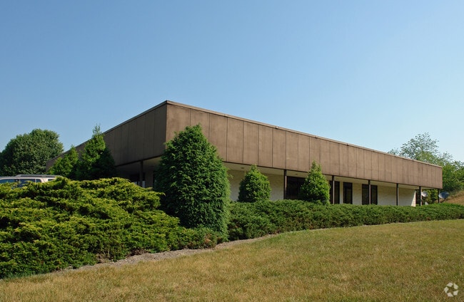
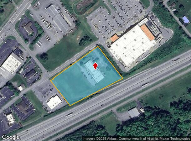
520 Forsythe Rd
189-3-3
4.910 ACRES TRACT 3,BIG SIX CORPORATION
Commercialnec
Bristol City
X
Virginia
51191C0265C
4.91 AC
2025
Bristol City County
2025
Kingsport/Bristol/Bristol
020400
Kingsport-Bristol-Bristol, TN-VA
18,517 SF
DEMOGRAPHICS near 520 Forsythe Rd
1 Mile
3 Mile
5 Mile
2024 Total Population
988
11,912
35,401
2029 Population
979
11,839
35,748
Pop Growth 2024-2029
(0.91%)
(0.61%)
+ 0.98%
Average Age
47
44
43
2024 Total Households
422
5,130
15,371
HH Growth 2024-2029
(0.95%)
(0.70%)
+ 0.98%
Median Household Inc
$49,740
$59,110
$48,816
Avg Household Size
2.30
2.30
2.20
2024 Avg HH Vehicles
2.00
2.00
2.00
Median Home Value
$203,571
$176,162
$166,820
Median Year Built
1974
1978
1973
Nearby Places
Map Layers
Map Styles
 Street
 Aerial
- Restaurants
- Banks
- Shops
- Fitness
- Groceries
PUBLIC TRANSPORTATION
AIRPORT
Tri-Cities
DRIVE
WALK
Distance
Tri-Cities
29 min
23.4 mi
Nearby Properties
Address
Land Use
TOTAL SIZE
Lot Size
Zoning
Address
Land Use
TOTAL SIZE
Lot Size
Zoning
249,912 SF
78.82 AC
A2 AGRICUL
Address
Land Use
TOTAL SIZE
Lot Size
Zoning
3,626 SF
120.17 AC
A2 AGRICUL
Address
Land Use
TOTAL SIZE
Lot Size
Zoning
105,868 SF
0.34 AC
A2 AGRICUL
Address
Land Use
TOTAL SIZE
Lot Size
Zoning
198,124 SF
17.67 AC
B2 BUSINES
Address
Land Use
TOTAL SIZE
Lot Size
Zoning
8,696 SF
250.89 AC
A2 AGRICUL
Address
Land Use
TOTAL SIZE
Lot Size
Zoning
166,980 SF
20.83 AC
B2 BUSINES
Address
Land Use
TOTAL SIZE
Lot Size
Zoning
133,840 SF
16.88 AC
B2 BUSINES
Address
Land Use
TOTAL SIZE
Lot Size
Zoning
87,952 SF
45.76 AC
M1 INDUSTR
Address
Land Use
TOTAL SIZE
Lot Size
Zoning
125,815 SF
31.42 AC
Address
Land Use
TOTAL SIZE
Lot Size
Zoning
131,291 SF
6.48 AC
Address
Land Use
TOTAL SIZE
Lot Size
Zoning
126,432 SF
13.87 AC
B2 BUSINES
Address
Land Use
TOTAL SIZE
Lot Size
Zoning
13,618 SF
174.42 AC
R2 RESIDEN
Address
Land Use
TOTAL SIZE
Lot Size
Zoning
87,400 SF
3.18 AC
Address
Land Use
TOTAL SIZE
Lot Size
Zoning
23,356 SF
4.54 AC
Address
Land Use
TOTAL SIZE
Lot Size
Zoning
10.84 AC
Address
Land Use
TOTAL SIZE
Lot Size
Zoning
99,368 SF
16.95 AC
Address
Land Use
TOTAL SIZE
Lot Size
Zoning
10.64 AC
Address
Land Use
TOTAL SIZE
Lot Size
Zoning
77,024 SF
0.13 AC
Address
Land Use
TOTAL SIZE
Lot Size
Zoning
40,168 SF
22.04 AC
R2 RESIDEN
Address
Land Use
TOTAL SIZE
Lot Size
Zoning
68,566 SF
1.42 AC
Address
Land Use
TOTAL SIZE
Lot Size
Zoning
68,566 SF
1.42 AC
Address
Land Use
TOTAL SIZE
Lot Size
Zoning
586,376 SF
60 AC
M2 INDUSTR
Address
Land Use
TOTAL SIZE
Lot Size
Zoning
57,770 SF
12 AC
A2 AGRICUL
Address
Land Use
TOTAL SIZE
Lot Size
Zoning
4.92 AC
Address
Land Use
TOTAL SIZE
Lot Size
Zoning
97,932 SF
9.88 AC
Address
Land Use
TOTAL SIZE
Lot Size
Zoning
38,272 SF
6.82 AC
B2 BUSINES
Address
Land Use
TOTAL SIZE
Lot Size
Zoning
98,482 SF
18.65 AC
B2 BUSINES
Address
Land Use
TOTAL SIZE
Lot Size
Zoning
32,722 SF
5.21 AC
B2 BUSINES
Address
Land Use
TOTAL SIZE
Lot Size
Zoning
2.88 AC
Address
Land Use
TOTAL SIZE
Lot Size
Zoning
48,555 SF
7.21 AC
The World's #1 Commercial Real Estate Marketplace
Connect with us
© 2025 CoStar Group
The information above has been obtained from sources believed reliable. While we do not doubt its accuracy we have not verified it and make no guarantee, warranty or representation about it. It is your responsibility to independently confirm its accuracy and completeness. Any projections, opinions, assumptions, or estimates used are for example only and do not represent the current or future performance of the property. The value of this transaction to you depends on tax and other factors which should be evaluated by your tax, financial, and legal advisors. You and your advisors should conduct a careful, independent investigation of the property to determine to your satisfaction the suitability of the property for your needs.