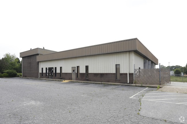
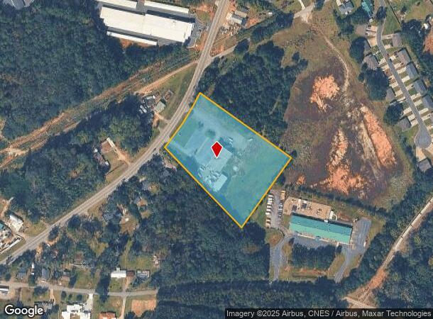
Property Record
520 Highway 29 Byp N, Anderson, SC 29621


NEARBY LISTINGS FOR SALE OR LEASE
Property Detail
520 Highway 29 Byp N
149-21-01-018
River Heights
Officebuilding
CP 090/887 F302 D501 HWY 29 4.00 AC
X
Anderson
45007C0263E
South Carolina
2025
4 AC
2024
Outlying Anderson Co
012300
Greenville/Spartanburg
6,050 SF
Greenville-Anderson-Mauldin, SC
DEMOGRAPHICS near 520 Highway 29 Byp N
1 Mile
3 Mile
5 Mile
2024 Total Population
3,074
28,211
64,491
2029 Population
3,278
30,257
69,292
Pop Growth 2024-2029
+ 6.64%
+ 7.25%
+ 7.44%
Average Age
36
39
40
2024 Total Households
1,176
10,940
25,587
HH Growth 2024-2029
+ 6.63%
+ 7.42%
+ 7.57%
Median Household Inc
$36,514
$42,777
$45,750
Avg Household Size
2.50
2.30
2.40
2024 Avg HH Vehicles
2.00
2.00
2.00
Median Home Value
$138,862
$152,092
$152,644
Median Year Built
1973
1977
1978
Nearby Places
Map Layers
Map Styles
 Street
 Aerial
- Restaurants
- Banks
- Shops
- Fitness
- Groceries
SALE & LEASE HISTORY
LISTING DATE
SALE/LEASE

Sep 24, 2016
For Sale
Nearby Properties
Address
Land Use
TOTAL SIZE
Lot Size
Zoning
Address
Land Use
TOTAL SIZE
Lot Size
Zoning
17,286 SF
19.71 AC
Address
Land Use
TOTAL SIZE
Lot Size
Zoning
13,220 SF
13.49 AC
Address
Land Use
TOTAL SIZE
Lot Size
Zoning
15,168 SF
11.99 AC
Address
Land Use
TOTAL SIZE
Lot Size
Zoning
7,568 SF
10.99 AC
Address
Land Use
TOTAL SIZE
Lot Size
Zoning
45,014 SF
0.29 AC
Address
Land Use
TOTAL SIZE
Lot Size
Zoning
3,920 SF
20.13 AC
Address
Land Use
TOTAL SIZE
Lot Size
Zoning
40,071 SF
18.83 AC
Address
Land Use
TOTAL SIZE
Lot Size
Zoning
61,281 SF
0.74 AC
Address
Land Use
TOTAL SIZE
Lot Size
Zoning
91,698 SF
10.04 AC
Address
Land Use
TOTAL SIZE
Lot Size
Zoning
0.74 AC
Address
Land Use
TOTAL SIZE
Lot Size
Zoning
110,140 SF
6 AC
Address
Land Use
TOTAL SIZE
Lot Size
Zoning
80,205 SF
9.58 AC
Address
Land Use
TOTAL SIZE
Lot Size
Zoning
149,148 SF
16.87 AC
Address
Land Use
TOTAL SIZE
Lot Size
Zoning
46,410 SF
4.88 AC
Address
Land Use
TOTAL SIZE
Lot Size
Zoning
24.90 AC
Address
Land Use
TOTAL SIZE
Lot Size
Zoning
9,406 SF
7.92 AC
Address
Land Use
TOTAL SIZE
Lot Size
Zoning
44,568 SF
2.47 AC
Address
Land Use
TOTAL SIZE
Lot Size
Zoning
1,408 SF
20.24 AC
Address
Land Use
TOTAL SIZE
Lot Size
Zoning
2,315 SF
Address
Land Use
TOTAL SIZE
Lot Size
Zoning
44,358 SF
6.25 AC
Address
Land Use
TOTAL SIZE
Lot Size
Zoning
14,749 SF
1.58 AC
Address
Land Use
TOTAL SIZE
Lot Size
Zoning
3,080 SF
1.04 AC
Address
Land Use
TOTAL SIZE
Lot Size
Zoning
28.04 AC
Address
Land Use
TOTAL SIZE
Lot Size
Zoning
24,661 SF
41.82 AC
Address
Land Use
TOTAL SIZE
Lot Size
Zoning
361 SF
9.69 AC
Address
Land Use
TOTAL SIZE
Lot Size
Zoning
19,728 SF
2.23 AC
Address
Land Use
TOTAL SIZE
Lot Size
Zoning
20,044 SF
0.23 AC
Address
Land Use
TOTAL SIZE
Lot Size
Zoning
6,220 SF
1.58 AC
The World's #1 Commercial Real Estate Marketplace
Connect with us
© 2025 CoStar Group
The information above has been obtained from sources believed reliable. While we do not doubt its accuracy we have not verified it and make no guarantee, warranty or representation about it. It is your responsibility to independently confirm its accuracy and completeness. Any projections, opinions, assumptions, or estimates used are for example only and do not represent the current or future performance of the property. The value of this transaction to you depends on tax and other factors which should be evaluated by your tax, financial, and legal advisors. You and your advisors should conduct a careful, independent investigation of the property to determine to your satisfaction the suitability of the property for your needs.