Property Record
520 N 2Nd Ave, Walla Walla, WA 99362
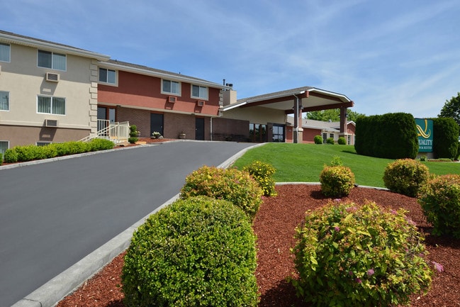


This Property Is For Sale
Property Detail
520 N 2Nd Ave
Walla Walla, WA
SHEILS ADDN PTN LOTS 9 THRU 13 AND 5 ALL LOTS 6-8 IN BLK 1 PTN OLDELM AVE ALSO PT LOTS 8, 10, 11, 12, & 13 IN BLK 9
360720730103
Walla Walla
Hotel
Washington
2025
s,s,s
2025
2.03 AC
920500
Washington State Area
26,769 SF
Other Market Areas
NEARBY LISTINGS FOR SALE OR LEASE
-
-
View all Walla Walla listings for sale on LoopNet.com
DEMOGRAPHICS near 520 N 2Nd Ave
1 mile
3 mile
5 mile
2025 Total Population
11,070
45,169
52,252
2030 Population
11,071
45,104
52,233
Pop Growth 2025-2030
+ 0.01%
(0.14%)
(0.04%)
Average Age
37
41
41
2025 Total Households
3,459
16,914
19,556
HH Growth 2025-2030
+ 0.26%
(0.18%)
(0.08%)
Median Household Inc
$46,783
$70,191
$70,750
Avg Household Size
2.30
2.40
2.40
2025 Avg HH Vehicles
2.00
2.00
2.00
Median Home Value
$331,893
$416,575
$425,192
Median Year Built
1948
1972
1974
Nearby Places
Map Layers
Map Styles
 Street
 Aerial
Layers
 Traffic
 Biking
Places
Listings with unknown addresses are not visible on the map
- Restaurants
- Banks
- Shops
- Fitness
- Groceries
PUBLIC TRANSPORTATION
AIRPORT
Walla Walla Regional
Drive
Walk
Distance
Walla Walla Regional
8 min
4.3 mi
Nearby Properties
Address
Land Use
TOTAL SIZE
Lot Size
Zoning
Address
Land Use
TOTAL SIZE
Lot Size
Zoning
118,836 SF
9.43 AC
Address
Land Use
TOTAL SIZE
Lot Size
Zoning
3.14 AC
Address
Land Use
TOTAL SIZE
Lot Size
Zoning
128,578 SF
10.56 AC
Address
Land Use
TOTAL SIZE
Lot Size
Zoning
200,872 SF
42.83 AC
Address
Land Use
TOTAL SIZE
Lot Size
Zoning
251,468 SF
6.17 AC
Address
Land Use
TOTAL SIZE
Lot Size
Zoning
65,472 SF
1.79 AC
Address
Land Use
TOTAL SIZE
Lot Size
Zoning
64,021 SF
2 AC
Address
Land Use
TOTAL SIZE
Lot Size
Zoning
128,366 SF
14.78 AC
Address
Land Use
TOTAL SIZE
Lot Size
Zoning
50,745 SF
4.10 AC
Address
Land Use
TOTAL SIZE
Lot Size
Zoning
114,582 SF
5.47 AC
Address
Land Use
TOTAL SIZE
Lot Size
Zoning
92,070 SF
3.82 AC
Address
Land Use
TOTAL SIZE
Lot Size
Zoning
171,813 SF
20.38 AC
Address
Land Use
TOTAL SIZE
Lot Size
Zoning
73,529 SF
4.32 AC
Address
Land Use
TOTAL SIZE
Lot Size
Zoning
76,064 SF
10.67 AC
Address
Land Use
TOTAL SIZE
Lot Size
Zoning
223,200 SF
11.21 AC
Address
Land Use
TOTAL SIZE
Lot Size
Zoning
52,166 SF
9.55 AC
Address
Land Use
TOTAL SIZE
Lot Size
Zoning
52,062 SF
9 AC
Address
Land Use
TOTAL SIZE
Lot Size
Zoning
91,972 SF
3.47 AC
Address
Land Use
TOTAL SIZE
Lot Size
Zoning
105,028 SF
4.50 AC
Address
Land Use
TOTAL SIZE
Lot Size
Zoning
55,687 SF
4 AC
Address
Land Use
TOTAL SIZE
Lot Size
Zoning
105,989 SF
0.69 AC
Address
Land Use
TOTAL SIZE
Lot Size
Zoning
55,152 SF
2.21 AC
Address
Land Use
TOTAL SIZE
Lot Size
Zoning
52,572 SF
13.13 AC
Address
Land Use
TOTAL SIZE
Lot Size
Zoning
59,987 SF
3.21 AC
Address
Land Use
TOTAL SIZE
Lot Size
Zoning
59,775 SF
7.15 AC
Address
Land Use
TOTAL SIZE
Lot Size
Zoning
65,624 SF
7.20 AC
Address
Land Use
TOTAL SIZE
Lot Size
Zoning
61,027 SF
3.46 AC
Address
Land Use
TOTAL SIZE
Lot Size
Zoning
53,838 SF
5.75 AC
Address
Land Use
TOTAL SIZE
Lot Size
Zoning
69,096 SF
1.81 AC
Address
Land Use
TOTAL SIZE
Lot Size
Zoning
42,749 SF
7.86 AC
The World's #1 Commercial Real Estate Marketplace
Connect with us
© 2026 CoStar Group
The information above has been obtained from sources believed reliable. While we do not doubt its accuracy we have not verified it and make no guarantee, warranty or representation about it. It is your responsibility to independently confirm its accuracy and completeness. Any projections, opinions, assumptions, or estimates used are for example only and do not represent the current or future performance of the property. The value of this transaction to you depends on tax and other factors which should be evaluated by your tax, financial, and legal advisors. You and your advisors should conduct a careful, independent investigation of the property to determine to your satisfaction the suitability of the property for your needs.