Property Record
520 N Fish Trap Rd, Easley, SC 29640
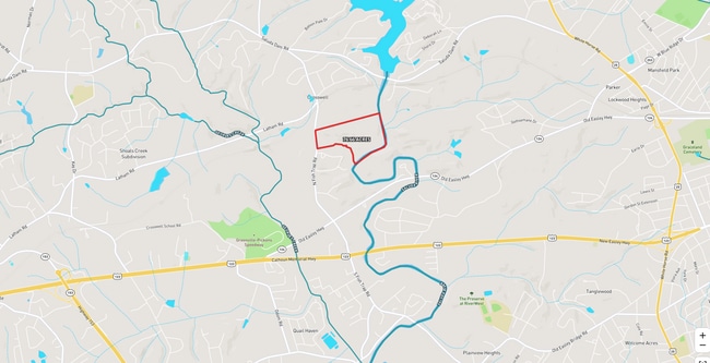
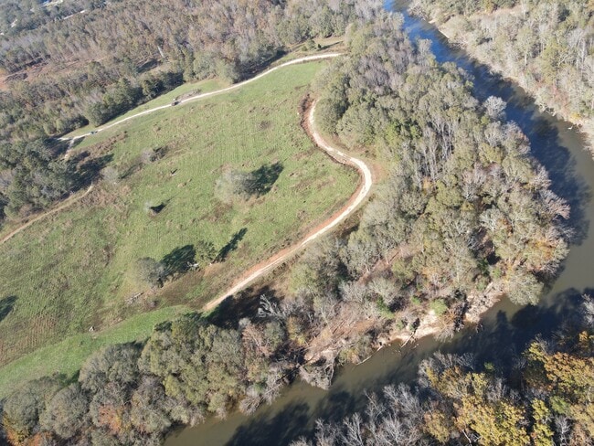
This Property Is For Sale
Property Detail
520 N Fish Trap Rd
Greenville-Anderson-Greer, SC
E/SIDE FISH TRAP RD PLAT 559/11
5059-06-29-8141
Pickens
Vacantlandnec
South Carolina
B and X Area of moderate flood hazard, usually the area between the limits of the 100-year and 500-year floods.
29.38 AC
2025
Outlying Pickens County
2025
Greenville/Spartanburg
010604
NEARBY LISTINGS FOR SALE OR LEASE
DEMOGRAPHICS near 520 N Fish Trap Rd
1 mile
3 mile
5 mile
2025 Total Population
2,384
27,804
101,854
2030 Population
2,536
29,622
109,453
Pop Growth 2025-2030
+ 6.38%
+ 6.54%
+ 7.46%
Average Age
39
39
39
2025 Total Households
882
10,623
40,675
HH Growth 2025-2030
+ 6.58%
+ 6.76%
+ 7.86%
Median Household Inc
$55,699
$56,690
$60,198
Avg Household Size
2.70
2.50
2.40
2025 Avg HH Vehicles
2.00
2.00
2.00
Median Home Value
$158,904
$209,706
$262,963
Median Year Built
1989
1984
1987
Nearby Places
Map Layers
Map Styles
 Street
 Aerial
Layers
 Traffic
 Biking
Places
Listings with unknown addresses are not visible on the map
- Restaurants
- Banks
- Shops
- Fitness
- Groceries
PUBLIC TRANSPORTATION
COMMUTER RAIL
Greenville Amtrak Station (Crescent - Amtrak)
Drive
Walk
Distance
Greenville Amtrak Station (Crescent - Amtrak)
13 min
6.2 mi
AIRPORT
Greenville Spartanburg International
Drive
Walk
Distance
Greenville Spartanburg International
35 min
20.5 mi
Freight Ports
North Charleston Terminal
Drive
Walk
Distance
North Charleston Terminal
242 min
212.6 mi
Nearby Properties
Address
Land Use
TOTAL SIZE
Lot Size
Zoning
Address
Land Use
TOTAL SIZE
Lot Size
Zoning
20.04 AC
RM
Address
Land Use
TOTAL SIZE
Lot Size
Zoning
10.10 AC
RM
Address
Land Use
TOTAL SIZE
Lot Size
Zoning
168 SF
10.10 AC
RM
Address
Land Use
TOTAL SIZE
Lot Size
Zoning
13.87 AC
RM20
Address
Land Use
TOTAL SIZE
Lot Size
Zoning
5.60 AC
RM
Address
Land Use
TOTAL SIZE
Lot Size
Zoning
4.97 AC
RM20
Address
Land Use
TOTAL SIZE
Lot Size
Zoning
4.70 AC
RM
Address
Land Use
TOTAL SIZE
Lot Size
Zoning
50.95 AC
R75
Address
Land Use
TOTAL SIZE
Lot Size
Zoning
153.11 AC
R10
Address
Land Use
TOTAL SIZE
Lot Size
Zoning
18.22 AC
RM
Address
Land Use
TOTAL SIZE
Lot Size
Zoning
105.62 AC
RS
Address
Land Use
TOTAL SIZE
Lot Size
Zoning
1.43 AC
C1N
Address
Land Use
TOTAL SIZE
Lot Size
Zoning
1,291 SF
6.34 AC
RM
Address
Land Use
TOTAL SIZE
Lot Size
Zoning
5,321 SF
3.38 AC
Address
Land Use
TOTAL SIZE
Lot Size
Zoning
1,410 SF
10.17 AC
R10
Address
Land Use
TOTAL SIZE
Lot Size
Zoning
24.69 AC
S1
Address
Land Use
TOTAL SIZE
Lot Size
Zoning
59.60 AC
RS
Address
Land Use
TOTAL SIZE
Lot Size
Zoning
3,008 SF
25.76 AC
C1
Address
Land Use
TOTAL SIZE
Lot Size
Zoning
22.50 AC
RM
Address
Land Use
TOTAL SIZE
Lot Size
Zoning
72.10 AC
RS
Address
Land Use
TOTAL SIZE
Lot Size
Zoning
6.35 AC
RM
Address
Land Use
TOTAL SIZE
Lot Size
Zoning
1,621 SF
50.70 AC
RS
Address
Land Use
TOTAL SIZE
Lot Size
Zoning
43 AC
R12
Address
Land Use
TOTAL SIZE
Lot Size
Zoning
28.82 AC
RS,S1
Address
Land Use
TOTAL SIZE
Lot Size
Zoning
4 AC
C-2
Address
Land Use
TOTAL SIZE
Lot Size
Zoning
15.59 AC
S1
Address
Land Use
TOTAL SIZE
Lot Size
Zoning
4.03 AC
RS
Address
Land Use
TOTAL SIZE
Lot Size
Zoning
45.40 AC
R12
Address
Land Use
TOTAL SIZE
Lot Size
Zoning
13.09 AC
RM
Address
Land Use
TOTAL SIZE
Lot Size
Zoning
1.29 AC
C2
The World's #1 Commercial Real Estate Marketplace
Connect with us
© 2026 CoStar Group
The information above has been obtained from sources believed reliable. While we do not doubt its accuracy we have not verified it and make no guarantee, warranty or representation about it. It is your responsibility to independently confirm its accuracy and completeness. Any projections, opinions, assumptions, or estimates used are for example only and do not represent the current or future performance of the property. The value of this transaction to you depends on tax and other factors which should be evaluated by your tax, financial, and legal advisors. You and your advisors should conduct a careful, independent investigation of the property to determine to your satisfaction the suitability of the property for your needs.