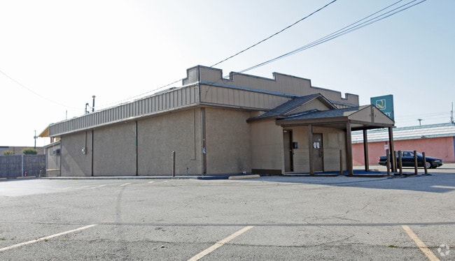
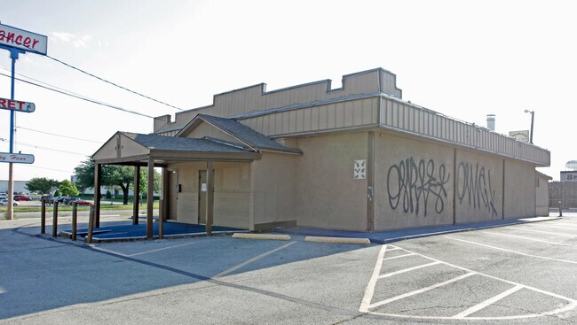
Property Record
520 N Watson Rd, Arlington, TX 76011

Save to a Folder
{{folder.Name}}
{{folder.ListingIds.length}} Properties
{{folder.ListingIds.length}} Property
Create a New Folder
Property Detail
520 N Watson Rd
Dallas-Fort Worth-Arlington, TX
GSID COMM NO 2 INST NO 1 BLOCK LOT 111C
42005122
Tarrant
Residentialacreage
Texas
B and X Area of moderate flood hazard, usually the area between the limits of the 100-year and 500-year floods.
111c
2025
0.80 AC
2025
North Grand Prairie
113005
Dallas/Ft Worth
2,730 SF
NEARBY LISTINGS FOR SALE OR LEASE
DEMOGRAPHICS near 520 N Watson Rd
1 mile
3 mile
5 mile
2025 Total Population
231
123,370
308,159
2030 Population
242
129,683
323,122
Pop Growth 2025-2030
+ 4.76%
+ 5.12%
+ 4.86%
Average Age
32
35
35
2025 Total Households
94
48,428
114,130
HH Growth 2025-2030
+ 5.32%
+ 5.33%
+ 5.06%
Median Household Inc
$41,538
$54,441
$60,243
Avg Household Size
2.30
2.50
2.60
2025 Avg HH Vehicles
1.00
2.00
2.00
Median Home Value
$191,666
$246,519
$271,606
Median Year Built
1973
1982
1982
Nearby Places
Map Layers
Map Styles
 Street
 Aerial
Layers
 Traffic
 Biking
Places
Listings with unknown addresses are not visible on the map
- Restaurants
- Banks
- Shops
- Fitness
- Groceries
PUBLIC TRANSPORTATION
COMMUTER RAIL
Centreport Station (TRINITY RAILWAY - Dallas Area Rapid Transit (DART))
Drive
Walk
Distance
Centreport Station (TRINITY RAILWAY - Dallas Area Rapid Transit (DART))
10 min
6.2 mi
West Tex Yard Limit (TRINITY RAILWAY - Dallas Area Rapid Transit (DART))
Drive
Walk
Distance
West Tex Yard Limit (TRINITY RAILWAY - Dallas Area Rapid Transit (DART))
16 min
8.2 mi
AIRPORT
Dallas-Fort Worth International
Drive
Walk
Distance
Dallas-Fort Worth International
19 min
12.4 mi
Dallas Love Field
Drive
Walk
Distance
Dallas Love Field
30 min
20.4 mi
Freight Ports
Port of Shreveport
Drive
Walk
Distance
Port of Shreveport
230 min
212.8 mi
SALE & LEASE HISTORY
LISTING DATE
SALE/LEASE

Sep 24, 2016
For Sale
Sep 14, 2017
For Lease
Sep 14, 2017
For Sale
Nearby Properties
Address
Land Use
TOTAL SIZE
Lot Size
Zoning
Address
Land Use
TOTAL SIZE
Lot Size
Zoning
1,700,000 SF
8.23 AC
Address
Land Use
TOTAL SIZE
Lot Size
Zoning
3,015,800 SF
72.86 AC
Address
Land Use
TOTAL SIZE
Lot Size
Zoning
1,400,000 SF
15.30 AC
Address
Land Use
TOTAL SIZE
Lot Size
Zoning
640,583 SF
Address
Land Use
TOTAL SIZE
Lot Size
Zoning
269,257 SF
21.33 AC
Address
Land Use
TOTAL SIZE
Lot Size
Zoning
287,560 SF
3.28 AC
Address
Land Use
TOTAL SIZE
Lot Size
Zoning
595,207 SF
7.20 AC
Address
Land Use
TOTAL SIZE
Lot Size
Zoning
5,995,915 SF
248.78 AC
Address
Land Use
TOTAL SIZE
Lot Size
Zoning
458,819 SF
15.88 AC
Address
Land Use
TOTAL SIZE
Lot Size
Zoning
1,577,320 SF
122.55 AC
Z123
Address
Land Use
TOTAL SIZE
Lot Size
Zoning
578,395 SF
6.22 AC
Address
Land Use
TOTAL SIZE
Lot Size
Zoning
347,421 SF
4.47 AC
Address
Land Use
TOTAL SIZE
Lot Size
Zoning
548,806 SF
5.56 AC
Address
Land Use
TOTAL SIZE
Lot Size
Zoning
1,261,810 SF
80.53 AC
Address
Land Use
TOTAL SIZE
Lot Size
Zoning
324,303 SF
23.15 AC
Address
Land Use
TOTAL SIZE
Lot Size
Zoning
450,535 SF
27.23 AC
Address
Land Use
TOTAL SIZE
Lot Size
Zoning
139,821 SF
Address
Land Use
TOTAL SIZE
Lot Size
Zoning
389,946 SF
2.35 AC
Address
Land Use
TOTAL SIZE
Lot Size
Zoning
753,721 SF
42.65 AC
Address
Land Use
TOTAL SIZE
Lot Size
Zoning
358,350 SF
13.15 AC
Address
Land Use
TOTAL SIZE
Lot Size
Zoning
402,935 SF
20.72 AC
Address
Land Use
TOTAL SIZE
Lot Size
Zoning
539,000 SF
3.91 AC
Address
Land Use
TOTAL SIZE
Lot Size
Zoning
1,054,767 SF
37.45 AC
Z123
Address
Land Use
TOTAL SIZE
Lot Size
Zoning
300,915 SF
24.90 AC
Address
Land Use
TOTAL SIZE
Lot Size
Zoning
285,194 SF
15.91 AC
Address
Land Use
TOTAL SIZE
Lot Size
Zoning
313,349 SF
15.39 AC
Address
Land Use
TOTAL SIZE
Lot Size
Zoning
137,878 SF
189.88 AC
Address
Land Use
TOTAL SIZE
Lot Size
Zoning
327,309 SF
3.45 AC
Address
Land Use
TOTAL SIZE
Lot Size
Zoning
334,660 SF
17.59 AC
Address
Land Use
TOTAL SIZE
Lot Size
Zoning
816,040 SF
41.89 AC
The World's #1 Commercial Real Estate Marketplace
Connect with us
© 2026 CoStar Group
The information above has been obtained from sources believed reliable. While we do not doubt its accuracy we have not verified it and make no guarantee, warranty or representation about it. It is your responsibility to independently confirm its accuracy and completeness. Any projections, opinions, assumptions, or estimates used are for example only and do not represent the current or future performance of the property. The value of this transaction to you depends on tax and other factors which should be evaluated by your tax, financial, and legal advisors. You and your advisors should conduct a careful, independent investigation of the property to determine to your satisfaction the suitability of the property for your needs.