Property Record
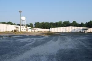
520 Pittman St, Fairmont, NC 28340


Property Detail
520 Pittman St
0505-05-017
A NW/S WHITE POND RD DBA MUNSING WEAR INC
Lightindustrial
ROBESON
GB
North Carolina
B and X Area of moderate flood hazard, usually the area between the limits of the 100-year and 500-year floods.
12.43 AC
2025
North Carolina Southeast Area
2025
Other Market Areas
961700
Lumberton, NC
137,860 SF
NEARBY LISTINGS FOR SALE OR LEASE
DEMOGRAPHICS near 520 Pittman St
1 mile
3 mile
5 mile
2025 Total Population
1,180
4,446
7,354
2030 Population
1,222
4,621
7,611
Pop Growth 2025-2030
+ 3.56%
+ 3.94%
+ 3.49%
Average Age
44
43
43
2025 Total Households
513
1,907
3,066
HH Growth 2025-2030
+ 3.70%
+ 3.93%
+ 3.49%
Median Household Inc
$38,333
$37,713
$38,214
Avg Household Size
2.30
2.30
2.30
2025 Avg HH Vehicles
2.00
2.00
2.00
Median Home Value
$76,008
$81,757
$83,306
Median Year Built
1975
1976
1978
Nearby Places
Map Layers
Map Styles
 Street
 Aerial
Layers
 Traffic
 Biking
Places
Listings with unknown addresses are not visible on the map
- Restaurants
- Banks
- Shops
- Fitness
- Groceries
PUBLIC TRANSPORTATION
AIRPORT
Fayetteville Regional/Grannis Field
Drive
Walk
Distance
Fayetteville Regional/Grannis Field
60 min
41.1 mi
SALE & LEASE HISTORY
LISTING DATE
SALE/LEASE

Sep 24, 2016
For Sale
Mar 10, 2017
For Lease
Nearby Properties
Address
Land Use
TOTAL SIZE
Lot Size
Zoning
Address
Land Use
TOTAL SIZE
Lot Size
Zoning
73,154 SF
42.94 AC
R15
Address
Land Use
TOTAL SIZE
Lot Size
Zoning
40,464 SF
6.98 AC
R10
Address
Land Use
TOTAL SIZE
Lot Size
Zoning
24,396 SF
6.91 AC
R5
Address
Land Use
TOTAL SIZE
Lot Size
Zoning
12,880 SF
20.15 AC
RA
Address
Land Use
TOTAL SIZE
Lot Size
Zoning
111 AC
RA
Address
Land Use
TOTAL SIZE
Lot Size
Zoning
43,830 SF
1.99 AC
R10
Address
Land Use
TOTAL SIZE
Lot Size
Zoning
31,176 SF
7.62 AC
R10
Address
Land Use
TOTAL SIZE
Lot Size
Zoning
53,052 SF
7.13 AC
CB
Address
Land Use
TOTAL SIZE
Lot Size
Zoning
48,088 SF
5.02 AC
RA
Address
Land Use
TOTAL SIZE
Lot Size
Zoning
51,170 SF
4.55 AC
CB
Address
Land Use
TOTAL SIZE
Lot Size
Zoning
12,375 SF
2.63 AC
GB
Address
Land Use
TOTAL SIZE
Lot Size
Zoning
13,095 SF
9.51 AC
RA
Address
Land Use
TOTAL SIZE
Lot Size
Zoning
6,144 SF
11.90 AC
RMH
Address
Land Use
TOTAL SIZE
Lot Size
Zoning
112.37 AC
RA
Address
Land Use
TOTAL SIZE
Lot Size
Zoning
16,650 SF
1.02 AC
R10
Address
Land Use
TOTAL SIZE
Lot Size
Zoning
1,104 SF
21.61 AC
RA
Address
Land Use
TOTAL SIZE
Lot Size
Zoning
13,650 SF
5 AC
RA
Address
Land Use
TOTAL SIZE
Lot Size
Zoning
8,456 SF
4.74 AC
RA
Address
Land Use
TOTAL SIZE
Lot Size
Zoning
4,347 SF
176 AC
R15
Address
Land Use
TOTAL SIZE
Lot Size
Zoning
12,920 SF
1.82 AC
R10
Address
Land Use
TOTAL SIZE
Lot Size
Zoning
9,484 SF
1.33 AC
Address
Land Use
TOTAL SIZE
Lot Size
Zoning
9,366 SF
29.36 AC
RA
Address
Land Use
TOTAL SIZE
Lot Size
Zoning
140,000 SF
5 AC
GB
Address
Land Use
TOTAL SIZE
Lot Size
Zoning
6,376 SF
2.43 AC
R15
Address
Land Use
TOTAL SIZE
Lot Size
Zoning
3,016 SF
3.88 AC
GB
Address
Land Use
TOTAL SIZE
Lot Size
Zoning
15,975 SF
11.59 AC
R15
Address
Land Use
TOTAL SIZE
Lot Size
Zoning
7,552 SF
1.04 AC
GB
Address
Land Use
TOTAL SIZE
Lot Size
Zoning
30.34 AC
RA
Address
Land Use
TOTAL SIZE
Lot Size
Zoning
1,982 SF
3.52 AC
R10
The World's #1 Commercial Real Estate Marketplace
Connect with us
© 2026 CoStar Group
The information above has been obtained from sources believed reliable. While we do not doubt its accuracy we have not verified it and make no guarantee, warranty or representation about it. It is your responsibility to independently confirm its accuracy and completeness. Any projections, opinions, assumptions, or estimates used are for example only and do not represent the current or future performance of the property. The value of this transaction to you depends on tax and other factors which should be evaluated by your tax, financial, and legal advisors. You and your advisors should conduct a careful, independent investigation of the property to determine to your satisfaction the suitability of the property for your needs.