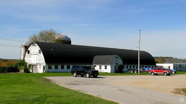
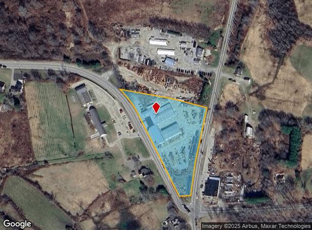
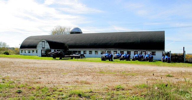
Property Record
520 Pond Rd, North Franklin, CT 06254
NEARBY LISTINGS FOR SALE OR LEASE
Property Detail
520 Pond Rd
Commercialnec
New London
X
Connecticut
09015C0325F
3.44 AC
2025
NE New London/Norwich
2025
Hartford
712100
Norwich-New London, CT
1,404 SF
FRAN-000012-000000-000023
DEMOGRAPHICS near 520 Pond Rd
1 Mile
3 Mile
5 Mile
2024 Total Population
242
3,028
10,766
2029 Population
238
3,001
10,636
Pop Growth 2024-2029
(1.65%)
(0.89%)
(1.21%)
Average Age
45
45
43
2024 Total Households
97
1,206
4,233
HH Growth 2024-2029
(2.06%)
(1.00%)
(1.28%)
Median Household Inc
$94,230
$79,081
$76,689
Avg Household Size
2.40
2.40
2.50
2024 Avg HH Vehicles
2.00
2.00
2.00
Median Home Value
$286,363
$274,020
$254,813
Median Year Built
1968
1963
1964
Nearby Places
Map Layers
Map Styles
 Street
 Aerial
- Restaurants
- Banks
- Shops
- Fitness
- Groceries
PUBLIC TRANSPORTATION
AIRPORT
Bradley International
DRIVE
WALK
Distance
Bradley International
71 min
45.7 mi
Freight Ports
Port of Davisville, RI
DRIVE
WALK
Distance
Port of Davisville, RI
79 min
46.1 mi
Nearby Properties
Address
Land Use
TOTAL SIZE
Lot Size
Zoning
Address
Land Use
TOTAL SIZE
Lot Size
Zoning
57,050 SF
17.60 AC
R120
Address
Land Use
TOTAL SIZE
Lot Size
Zoning
72,759 SF
9.86 AC
Address
Land Use
TOTAL SIZE
Lot Size
Zoning
38.48 AC
R3
Address
Land Use
TOTAL SIZE
Lot Size
Zoning
112 AC
R080
Address
Land Use
TOTAL SIZE
Lot Size
Zoning
12.02 AC
C-2
Address
Land Use
TOTAL SIZE
Lot Size
Zoning
31.05 AC
Address
Land Use
TOTAL SIZE
Lot Size
Zoning
114.45 AC
Address
Land Use
TOTAL SIZE
Lot Size
Zoning
Address
Land Use
TOTAL SIZE
Lot Size
Zoning
98,652 SF
325 AC
R080
Address
Land Use
TOTAL SIZE
Lot Size
Zoning
2.35 AC
M2 - 1
Address
Land Use
TOTAL SIZE
Lot Size
Zoning
11,272 SF
88 AC
R-80
Address
Land Use
TOTAL SIZE
Lot Size
Zoning
91.60 AC
R080
Address
Land Use
TOTAL SIZE
Lot Size
Zoning
5.62 AC
C-2
Address
Land Use
TOTAL SIZE
Lot Size
Zoning
4,608 SF
183.27 AC
R080
Address
Land Use
TOTAL SIZE
Lot Size
Zoning
7.40 AC
Address
Land Use
TOTAL SIZE
Lot Size
Zoning
10,099 SF
0.83 AC
Address
Land Use
TOTAL SIZE
Lot Size
Zoning
77 AC
R080
Address
Land Use
TOTAL SIZE
Lot Size
Zoning
327,116 SF
188.18 AC
C-2
Address
Land Use
TOTAL SIZE
Lot Size
Zoning
3,206 SF
0.76 AC
C1
Address
Land Use
TOTAL SIZE
Lot Size
Zoning
51 AC
R080
Address
Land Use
TOTAL SIZE
Lot Size
Zoning
75.50 AC
R120
Address
Land Use
TOTAL SIZE
Lot Size
Zoning
7,261 SF
0.98 AC
Address
Land Use
TOTAL SIZE
Lot Size
Zoning
4,790 SF
1.20 AC
R080
Address
Land Use
TOTAL SIZE
Lot Size
Zoning
39.02 AC
Address
Land Use
TOTAL SIZE
Lot Size
Zoning
1,078 SF
36.07 AC
Address
Land Use
TOTAL SIZE
Lot Size
Zoning
2,394 SF
42.85 AC
R3
Address
Land Use
TOTAL SIZE
Lot Size
Zoning
149.70 AC
RU-A
Address
Land Use
TOTAL SIZE
Lot Size
Zoning
1,197 SF
172.50 AC
R120
Address
Land Use
TOTAL SIZE
Lot Size
Zoning
5,104 SF
1.49 AC
C-1
The World's #1 Commercial Real Estate Marketplace
Connect with us
© 2026 CoStar Group
The information above has been obtained from sources believed reliable. While we do not doubt its accuracy we have not verified it and make no guarantee, warranty or representation about it. It is your responsibility to independently confirm its accuracy and completeness. Any projections, opinions, assumptions, or estimates used are for example only and do not represent the current or future performance of the property. The value of this transaction to you depends on tax and other factors which should be evaluated by your tax, financial, and legal advisors. You and your advisors should conduct a careful, independent investigation of the property to determine to your satisfaction the suitability of the property for your needs.