Property Record
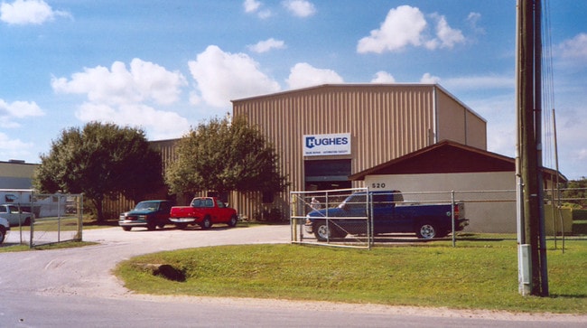
520 Prairie Industrial Pky, Mulberry, FL 33860


NEARBY LISTINGS FOR SALE OR LEASE
Property Detail
520 Prairie Industrial Pky
23-30-03-000000-023030
Fuller Heights
Lightindustrial
COMM SE COR SW1/4 OF NE1/4 RUN W 376.6 FT TO W-R/W N PRAIRIE IND PK BLVD S 627.43 FT FOR POB RUN W 587.31 FT TO ELY R/W SCLRR S 222.51 FT E 585.44 FT TO RD R/W N 222.51 FT TO POB
X
Polk
12105C0490G
Florida
2024
2.99 AC
2025
Polk County
014802
Tampa/St Petersburg
12,950 SF
Lakeland-Winter Haven, FL
DEMOGRAPHICS near 520 Prairie Industrial Pky
1 Mile
3 Mile
5 Mile
2024 Total Population
1,017
23,852
53,045
2029 Population
1,177
27,743
61,386
Pop Growth 2024-2029
+ 15.73%
+ 16.31%
+ 15.72%
Average Age
37
38
39
2024 Total Households
368
8,528
19,271
HH Growth 2024-2029
+ 15.76%
+ 16.36%
+ 15.77%
Median Household Inc
$44,903
$58,015
$70,982
Avg Household Size
2.70
2.70
2.70
2024 Avg HH Vehicles
2.00
2.00
2.00
Median Home Value
$230,833
$193,653
$248,545
Median Year Built
1985
1993
1993
Nearby Places
Map Layers
Map Styles
 Street
 Aerial
- Restaurants
- Banks
- Shops
- Fitness
- Groceries
PUBLIC TRANSPORTATION
AIRPORT
Tampa International
DRIVE
WALK
Distance
Tampa International
58 min
38.2 mi
Freight Ports
Port of Tampa Bay
DRIVE
WALK
Distance
Port of Tampa Bay
48 min
31.1 mi
Nearby Properties
Address
Land Use
TOTAL SIZE
Lot Size
Zoning
Address
Land Use
TOTAL SIZE
Lot Size
Zoning
882,663 SF
133.57 AC
PUD
Address
Land Use
TOTAL SIZE
Lot Size
Zoning
306,126 SF
25.03 AC
Address
Land Use
TOTAL SIZE
Lot Size
Zoning
214,889 SF
23.50 AC
Address
Land Use
TOTAL SIZE
Lot Size
Zoning
166,313 SF
63.97 AC
Address
Land Use
TOTAL SIZE
Lot Size
Zoning
126,269 SF
16.35 AC
Address
Land Use
TOTAL SIZE
Lot Size
Zoning
174,251 SF
26.66 AC
Address
Land Use
TOTAL SIZE
Lot Size
Zoning
145,672 SF
16 AC
Address
Land Use
TOTAL SIZE
Lot Size
Zoning
116,961 SF
5.01 AC
I1
Address
Land Use
TOTAL SIZE
Lot Size
Zoning
81,706 SF
20.35 AC
Address
Land Use
TOTAL SIZE
Lot Size
Zoning
66,800 SF
8.65 AC
Address
Land Use
TOTAL SIZE
Lot Size
Zoning
104,418 SF
20.10 AC
Address
Land Use
TOTAL SIZE
Lot Size
Zoning
79,100 SF
4.72 AC
PUD
Address
Land Use
TOTAL SIZE
Lot Size
Zoning
95,863 SF
8.10 AC
Address
Land Use
TOTAL SIZE
Lot Size
Zoning
103,698 SF
10.86 AC
GI
Address
Land Use
TOTAL SIZE
Lot Size
Zoning
56,689 SF
9.30 AC
Address
Land Use
TOTAL SIZE
Lot Size
Zoning
88,138 SF
7.48 AC
Address
Land Use
TOTAL SIZE
Lot Size
Zoning
41,093 SF
1.58 AC
C1
Address
Land Use
TOTAL SIZE
Lot Size
Zoning
50,303 SF
5.80 AC
Address
Land Use
TOTAL SIZE
Lot Size
Zoning
27,580 SF
10.96 AC
RC
Address
Land Use
TOTAL SIZE
Lot Size
Zoning
59,860 SF
10.48 AC
GI
Address
Land Use
TOTAL SIZE
Lot Size
Zoning
68,151 SF
18.63 AC
Address
Land Use
TOTAL SIZE
Lot Size
Zoning
14,835 SF
8.96 AC
C2
Address
Land Use
TOTAL SIZE
Lot Size
Zoning
93,186 SF
2.67 AC
I1
Address
Land Use
TOTAL SIZE
Lot Size
Zoning
24,988 SF
8.28 AC
Address
Land Use
TOTAL SIZE
Lot Size
Zoning
17,380 SF
3.43 AC
Address
Land Use
TOTAL SIZE
Lot Size
Zoning
16,955 SF
2.65 AC
Address
Land Use
TOTAL SIZE
Lot Size
Zoning
12,452 SF
2.49 AC
C1
Address
Land Use
TOTAL SIZE
Lot Size
Zoning
28,852 SF
5.19 AC
C2
Address
Land Use
TOTAL SIZE
Lot Size
Zoning
15,048 SF
4.73 AC
Address
Land Use
TOTAL SIZE
Lot Size
Zoning
23.86 AC
The World's #1 Commercial Real Estate Marketplace
Connect with us
© 2026 CoStar Group
The information above has been obtained from sources believed reliable. While we do not doubt its accuracy we have not verified it and make no guarantee, warranty or representation about it. It is your responsibility to independently confirm its accuracy and completeness. Any projections, opinions, assumptions, or estimates used are for example only and do not represent the current or future performance of the property. The value of this transaction to you depends on tax and other factors which should be evaluated by your tax, financial, and legal advisors. You and your advisors should conduct a careful, independent investigation of the property to determine to your satisfaction the suitability of the property for your needs.