Property Record
520 Ryan St, Boonville, MO 65233
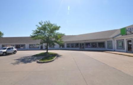


Property Detail
520 Ryan St
10-1.0-02-004-001-001.003
SP...POB S 360, W 638, N 157, W 155, NE 54, NE 112, NE 54, E 762, EXCEPT PARCEL #S 1.04, 1.06, 1.011, 1.017, 1.018, AND 1.019
Communitycenter
COOPER
B and X Area of moderate flood hazard, usually the area between the limits of the 100-year and 500-year floods.
Missouri
2024
5 AC
2025
Missouri North Area
950400
Other Market Areas
6,950 SF
Columbia, MO
NEARBY LISTINGS FOR SALE OR LEASE
-
-
View all Boonville listings for sale on LoopNet.com
DEMOGRAPHICS near 520 Ryan St
1 mile
3 mile
5 mile
2025 Total Population
3,413
9,010
11,078
2030 Population
3,482
9,186
11,259
Pop Growth 2025-2030
+ 2.02%
+ 1.95%
+ 1.63%
Average Age
42
42
42
2025 Total Households
1,408
3,520
4,389
HH Growth 2025-2030
+ 1.99%
+ 2.41%
+ 1.94%
Median Household Inc
$61,490
$61,090
$62,264
Avg Household Size
2.30
2.30
2.30
2025 Avg HH Vehicles
2.00
2.00
2.00
Median Home Value
$215,683
$205,691
$199,849
Median Year Built
1975
1970
1970
Nearby Places
Map Layers
Map Styles
 Street
 Aerial
Layers
 Traffic
 Biking
Places
Listings with unknown addresses are not visible on the map
- Restaurants
- Banks
- Shops
- Fitness
- Groceries
PUBLIC TRANSPORTATION
AIRPORT
Columbia Regional
Drive
Walk
Distance
Columbia Regional
47 min
39.0 mi
Freight Ports
Tulsa Port of Inola
Drive
Walk
Distance
Tulsa Port of Inola
380 min
322.0 mi
SALE & LEASE HISTORY
LISTING DATE
SALE/LEASE

Sep 25, 2019
For Sale
Sep 25, 2016
For Lease
Sep 24, 2016
For Sale
Nearby Properties
Address
Land Use
TOTAL SIZE
Lot Size
Zoning
Address
Land Use
TOTAL SIZE
Lot Size
Zoning
32,615 SF
18 AC
Address
Land Use
TOTAL SIZE
Lot Size
Zoning
138,122 SF
28 AC
Address
Land Use
TOTAL SIZE
Lot Size
Zoning
255,380 SF
18 AC
Address
Land Use
TOTAL SIZE
Lot Size
Zoning
163,450 SF
17 AC
Address
Land Use
TOTAL SIZE
Lot Size
Zoning
9,874 SF
14 AC
Address
Land Use
TOTAL SIZE
Lot Size
Zoning
10,980 SF
22 AC
Address
Land Use
TOTAL SIZE
Lot Size
Zoning
75,200 SF
8 AC
Address
Land Use
TOTAL SIZE
Lot Size
Zoning
18,603 SF
4 AC
Address
Land Use
TOTAL SIZE
Lot Size
Zoning
10,311 SF
18 AC
Address
Land Use
TOTAL SIZE
Lot Size
Zoning
33,739 SF
2 AC
Address
Land Use
TOTAL SIZE
Lot Size
Zoning
43,770 SF
6 AC
Address
Land Use
TOTAL SIZE
Lot Size
Zoning
6,172 SF
12 AC
Address
Land Use
TOTAL SIZE
Lot Size
Zoning
20,000 SF
Address
Land Use
TOTAL SIZE
Lot Size
Zoning
5,426 SF
15 AC
Address
Land Use
TOTAL SIZE
Lot Size
Zoning
20,794 SF
3 AC
Address
Land Use
TOTAL SIZE
Lot Size
Zoning
51,134 SF
11 AC
Address
Land Use
TOTAL SIZE
Lot Size
Zoning
4,300 SF
1 AC
Address
Land Use
TOTAL SIZE
Lot Size
Zoning
5,585 SF
3 AC
Address
Land Use
TOTAL SIZE
Lot Size
Zoning
21,296 SF
4 AC
Address
Land Use
TOTAL SIZE
Lot Size
Zoning
15,429 SF
1 AC
Address
Land Use
TOTAL SIZE
Lot Size
Zoning
1 SF
4 AC
Address
Land Use
TOTAL SIZE
Lot Size
Zoning
9,600 SF
9 AC
Address
Land Use
TOTAL SIZE
Lot Size
Zoning
6,260 SF
1 AC
Address
Land Use
TOTAL SIZE
Lot Size
Zoning
2,918 SF
8 AC
Address
Land Use
TOTAL SIZE
Lot Size
Zoning
3,869 SF
2 AC
Address
Land Use
TOTAL SIZE
Lot Size
Zoning
15,644 SF
3 AC
Address
Land Use
TOTAL SIZE
Lot Size
Zoning
23,975 SF
2 AC
The World's #1 Commercial Real Estate Marketplace
Connect with us
© 2026 CoStar Group
The information above has been obtained from sources believed reliable. While we do not doubt its accuracy we have not verified it and make no guarantee, warranty or representation about it. It is your responsibility to independently confirm its accuracy and completeness. Any projections, opinions, assumptions, or estimates used are for example only and do not represent the current or future performance of the property. The value of this transaction to you depends on tax and other factors which should be evaluated by your tax, financial, and legal advisors. You and your advisors should conduct a careful, independent investigation of the property to determine to your satisfaction the suitability of the property for your needs.