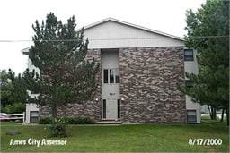
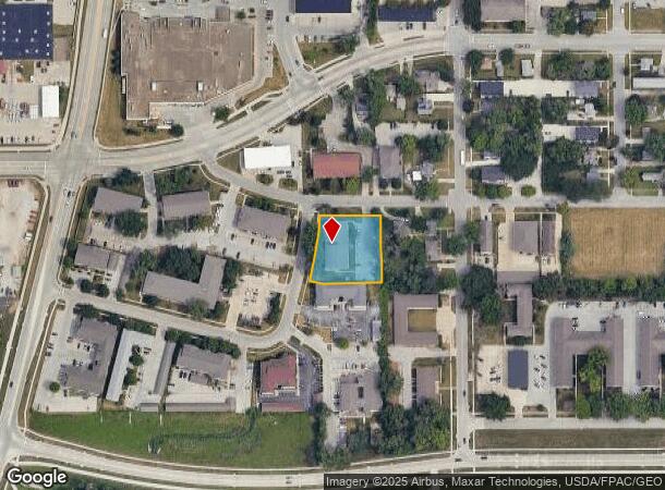
Property Record
520 S 4Th St, Ames, IA 50010
NEARBY LISTINGS FOR SALE OR LEASE
Property Detail
520 S 4Th St
Ames, IA
Cooper's 2Nd Sd
09-11-150-100
COOPERS 2ND SD LOT:4 AMES
Apartment
Story
X
Iowa
19169C0163G
4
2024
0.74 AC
2025
East Ames
001000
Other Market Areas
20,000 SF
DEMOGRAPHICS near 520 S 4Th St
1 mile
3 mile
5 mile
2024 Total Population
7,660
49,405
68,182
2029 Population
7,855
50,779
70,244
Pop Growth 2024-2029
+ 2.55%
+ 2.78%
+ 3.02%
Average Age
32
33
33
2024 Total Households
3,865
20,313
27,476
HH Growth 2024-2029
+ 2.74%
+ 3.21%
+ 3.42%
Median Household Inc
$48,566
$52,673
$57,920
Avg Household Size
1.90
2.00
2.10
2024 Avg HH Vehicles
2.00
2.00
2.00
Median Home Value
$163,582
$238,946
$251,240
Median Year Built
1973
1985
1990
Nearby Places
Map Layers
Map Styles
 Street
 Aerial
Transit
 Traffic
 Biking
Places
Listings with unknown addresses are not visible on the map
- Restaurants
- Banks
- Shops
- Fitness
- Groceries
Nearby Properties
Address
Land Use
TOTAL SIZE
Lot Size
Zoning
Address
Land Use
TOTAL SIZE
Lot Size
Zoning
2,400 SF
146.13 AC
PI
Address
Land Use
TOTAL SIZE
Lot Size
Zoning
2,216 SF
25.86 AC
RH
Address
Land Use
TOTAL SIZE
Lot Size
Zoning
54,112 SF
12.70 AC
Address
Land Use
TOTAL SIZE
Lot Size
Zoning
576,476 SF
23.76 AC
GI
Address
Land Use
TOTAL SIZE
Lot Size
Zoning
289,606 SF
1.77 AC
CSC
Address
Land Use
TOTAL SIZE
Lot Size
Zoning
33,530 SF
28.91 AC
Address
Land Use
TOTAL SIZE
Lot Size
Zoning
45,627 SF
8.91 AC
RH
Address
Land Use
TOTAL SIZE
Lot Size
Zoning
215,689 SF
22.56 AC
HOC
Address
Land Use
TOTAL SIZE
Lot Size
Zoning
75,302 SF
16.66 AC
HOC
Address
Land Use
TOTAL SIZE
Lot Size
Zoning
177,201 SF
26.29 AC
Address
Land Use
TOTAL SIZE
Lot Size
Zoning
117,797 SF
7.88 AC
Address
Land Use
TOTAL SIZE
Lot Size
Zoning
82,734 SF
1.42 AC
CSC
Address
Land Use
TOTAL SIZE
Lot Size
Zoning
3,500 SF
56.27 AC
GI
Address
Land Use
TOTAL SIZE
Lot Size
Zoning
156,833 SF
14.54 AC
PRC
Address
Land Use
TOTAL SIZE
Lot Size
Zoning
262,786 SF
16.05 AC
GI
Address
Land Use
TOTAL SIZE
Lot Size
Zoning
78,379 SF
7.92 AC
SHM
Address
Land Use
TOTAL SIZE
Lot Size
Zoning
3,456 SF
4.99 AC
Address
Land Use
TOTAL SIZE
Lot Size
Zoning
120,842 SF
26.68 AC
PI
Address
Land Use
TOTAL SIZE
Lot Size
Zoning
52,980 SF
8.53 AC
PI
Address
Land Use
TOTAL SIZE
Lot Size
Zoning
6,090 SF
20.72 AC
F-PRD
Address
Land Use
TOTAL SIZE
Lot Size
Zoning
93,813 SF
7.11 AC
GI
Address
Land Use
TOTAL SIZE
Lot Size
Zoning
20,619 SF
2.44 AC
RH
Address
Land Use
TOTAL SIZE
Lot Size
Zoning
54,066 SF
4.93 AC
RI
Address
Land Use
TOTAL SIZE
Lot Size
Zoning
384 SF
62.77 AC
GI
Address
Land Use
TOTAL SIZE
Lot Size
Zoning
171,800 SF
19.34 AC
PI
Address
Land Use
TOTAL SIZE
Lot Size
Zoning
84,132 SF
3.57 AC
FS-RM
Address
Land Use
TOTAL SIZE
Lot Size
Zoning
115,338 SF
16.41 AC
HOC
Address
Land Use
TOTAL SIZE
Lot Size
Zoning
35,264 SF
11.88 AC
Address
Land Use
TOTAL SIZE
Lot Size
Zoning
105,550 SF
0.62 AC
CSC
Address
Land Use
TOTAL SIZE
Lot Size
Zoning
7,181 SF
20.11 AC
PRC
The World's #1 Commercial Real Estate Marketplace
Connect with us
© 2026 CoStar Group
The information above has been obtained from sources believed reliable. While we do not doubt its accuracy we have not verified it and make no guarantee, warranty or representation about it. It is your responsibility to independently confirm its accuracy and completeness. Any projections, opinions, assumptions, or estimates used are for example only and do not represent the current or future performance of the property. The value of this transaction to you depends on tax and other factors which should be evaluated by your tax, financial, and legal advisors. You and your advisors should conduct a careful, independent investigation of the property to determine to your satisfaction the suitability of the property for your needs.