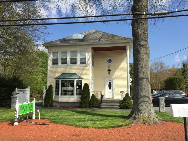
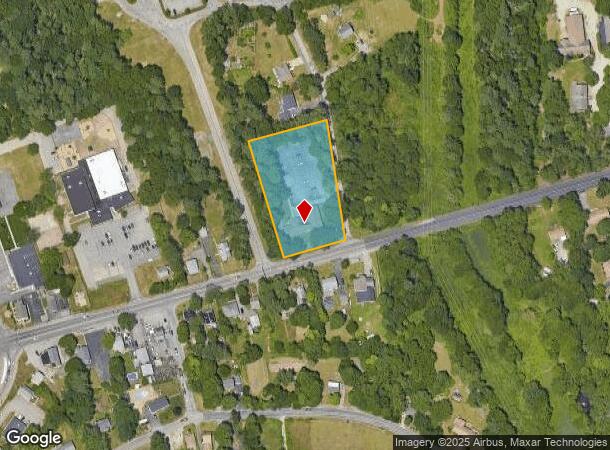
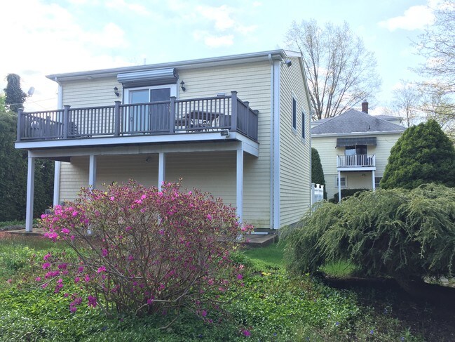
Property Record
520 Taunton Ave, Seekonk, MA 02771
NEARBY LISTINGS FOR SALE OR LEASE
-
-
View all Seekonk listings for sale on LoopNet.com
Property Detail
520 Taunton Ave
SEEK-000180-000000-000120
Bristol
Medicalbuilding
Massachusetts
X
120
44007C0329H
1.79 AC
2025
Outlying Bristol County
2025
Boston
632200
Providence-Warwick, RI-MA
10,105 SF
DEMOGRAPHICS near 520 Taunton Ave
1 Mile
3 Mile
5 Mile
2024 Total Population
2,925
44,612
196,338
2029 Population
2,906
44,422
195,207
Pop Growth 2024-2029
(0.65%)
(0.43%)
(0.58%)
Average Age
42
43
40
2024 Total Households
1,083
18,737
80,641
HH Growth 2024-2029
(0.74%)
(0.52%)
(0.51%)
Median Household Inc
$91,341
$71,535
$68,535
Avg Household Size
2.70
2.30
2.20
2024 Avg HH Vehicles
2.00
2.00
2.00
Median Home Value
$420,339
$336,558
$331,191
Median Year Built
1953
1959
1951
Nearby Places
Map Layers
Map Styles
 Street
 Aerial
- Restaurants
- Banks
- Shops
- Fitness
- Groceries
PUBLIC TRANSPORTATION
COMMUTER RAIL
Providence (Providence/Stoughton Line - Massachusetts Bay Transportation Authority Commuter Rail (Purple Line))
DRIVE
WALK
Distance
Providence (Providence/Stoughton Line - Massachusetts Bay Transportation Authority Commuter Rail (Purple Line))
9 min
5.2 mi
Pawtucket/Central Falls (Foxboro Event Service - MBTA, Providence/Stoughton Line - MBTA)
DRIVE
WALK
Distance
Pawtucket/Central Falls (Foxboro Event Service - MBTA, Providence/Stoughton Line - MBTA)
11 min
6.0 mi
AIRPORT
Rhode Island Tf Green International
DRIVE
WALK
Distance
Rhode Island Tf Green International
22 min
12.1 mi
Freight Ports
Port of Davisville, RI
DRIVE
WALK
Distance
Port of Davisville, RI
39 min
24.5 mi
SALE & LEASE HISTORY
LISTING DATE
SALE/LEASE

Sep 24, 2016
For Sale
Nearby Properties
Address
Land Use
TOTAL SIZE
Lot Size
Zoning
Address
Land Use
TOTAL SIZE
Lot Size
Zoning
317,728 SF
28.20 AC
O1
Address
Land Use
TOTAL SIZE
Lot Size
Zoning
79.57 AC
O1
Address
Land Use
TOTAL SIZE
Lot Size
Zoning
193.69 AC
PO
Address
Land Use
TOTAL SIZE
Lot Size
Zoning
38.09 AC
CD
Address
Land Use
TOTAL SIZE
Lot Size
Zoning
455.47 AC
I3
Address
Land Use
TOTAL SIZE
Lot Size
Zoning
139.58 AC
O1
Address
Land Use
TOTAL SIZE
Lot Size
Zoning
225,067 SF
40.70 AC
HB
Address
Land Use
TOTAL SIZE
Lot Size
Zoning
8.05 AC
C1
Address
Land Use
TOTAL SIZE
Lot Size
Zoning
18.01 AC
C3
Address
Land Use
TOTAL SIZE
Lot Size
Zoning
4.62 AC
R5
Address
Land Use
TOTAL SIZE
Lot Size
Zoning
12.67 AC
R5
Address
Land Use
TOTAL SIZE
Lot Size
Zoning
170,345 SF
3.76 AC
R6
Address
Land Use
TOTAL SIZE
Lot Size
Zoning
171,290 SF
27.80 AC
R2
Address
Land Use
TOTAL SIZE
Lot Size
Zoning
6.89 AC
RS
Address
Land Use
TOTAL SIZE
Lot Size
Zoning
339,222 SF
32.67 AC
PA
Address
Land Use
TOTAL SIZE
Lot Size
Zoning
223,374 SF
14 AC
O1
Address
Land Use
TOTAL SIZE
Lot Size
Zoning
200,200 SF
11.64 AC
I1
Address
Land Use
TOTAL SIZE
Lot Size
Zoning
105,859 SF
16.08 AC
HB
Address
Land Use
TOTAL SIZE
Lot Size
Zoning
105,859 SF
16.08 AC
HB
Address
Land Use
TOTAL SIZE
Lot Size
Zoning
139,692 SF
15.92 AC
HB
Address
Land Use
TOTAL SIZE
Lot Size
Zoning
1.29 AC
R5
Address
Land Use
TOTAL SIZE
Lot Size
Zoning
153,005 SF
10.57 AC
DR
Address
Land Use
TOTAL SIZE
Lot Size
Zoning
9.81 AC
R5
Address
Land Use
TOTAL SIZE
Lot Size
Zoning
117,360 SF
18.43 AC
I3
Address
Land Use
TOTAL SIZE
Lot Size
Zoning
126,183 SF
13.02 AC
HB
Address
Land Use
TOTAL SIZE
Lot Size
Zoning
133,632 SF
17.49 AC
I3
Address
Land Use
TOTAL SIZE
Lot Size
Zoning
21.48 AC
O1
Address
Land Use
TOTAL SIZE
Lot Size
Zoning
117,041 SF
14.71 AC
HB
Address
Land Use
TOTAL SIZE
Lot Size
Zoning
91,883 SF
8 AC
HB
Address
Land Use
TOTAL SIZE
Lot Size
Zoning
91,883 SF
8 AC
HB
The World's #1 Commercial Real Estate Marketplace
Connect with us
© 2025 CoStar Group
The information above has been obtained from sources believed reliable. While we do not doubt its accuracy we have not verified it and make no guarantee, warranty or representation about it. It is your responsibility to independently confirm its accuracy and completeness. Any projections, opinions, assumptions, or estimates used are for example only and do not represent the current or future performance of the property. The value of this transaction to you depends on tax and other factors which should be evaluated by your tax, financial, and legal advisors. You and your advisors should conduct a careful, independent investigation of the property to determine to your satisfaction the suitability of the property for your needs.