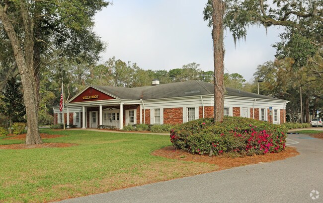
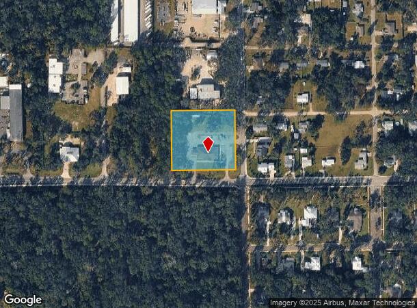
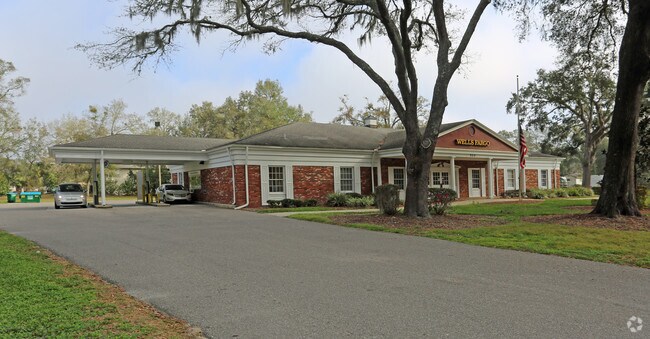
Property Record
520 W Main St, Lake Helen, FL 32744
NEARBY LISTINGS FOR SALE OR LEASE
Property Detail
520 W Main St
7130-02-19-0030
Lake Helen
Officebuilding
S 1/2 OF E 1/2 BLK 122 LAKE HELEN MB 2 PG 93 PER OR 2178 PG 973 PER OR 7555 PG 335
X
Volusia
12127C0630K
Florida
2025
2.19 AC
2025
SE Volusia County
091001
Deltona/Daytona Beach
7,345 SF
Deltona-Daytona Beach-Ormond Beach, FL
DEMOGRAPHICS near 520 W Main St
1 Mile
3 Mile
5 Mile
2024 Total Population
2,716
19,267
81,035
2029 Population
3,026
21,532
89,394
Pop Growth 2024-2029
+ 11.41%
+ 11.76%
+ 10.32%
Average Age
46
45
42
2024 Total Households
1,110
7,638
30,651
HH Growth 2024-2029
+ 11.53%
+ 11.91%
+ 10.45%
Median Household Inc
$69,886
$76,377
$63,479
Avg Household Size
2.40
2.50
2.50
2024 Avg HH Vehicles
2.00
2.00
2.00
Median Home Value
$326,324
$303,322
$238,952
Median Year Built
1989
2003
1988
Nearby Places
Map Layers
Map Styles
 Street
 Aerial
- Restaurants
- Banks
- Shops
- Fitness
- Groceries
PUBLIC TRANSPORTATION
AIRPORT
Daytona Beach International
DRIVE
WALK
Distance
Daytona Beach International
26 min
19.6 mi
Orlando Sanford International
DRIVE
WALK
Distance
Orlando Sanford International
34 min
22.0 mi
SALE & LEASE HISTORY
LISTING DATE
SALE/LEASE

Feb 16, 2018
For Sale
Nearby Properties
Address
Land Use
TOTAL SIZE
Lot Size
Zoning
Address
Land Use
TOTAL SIZE
Lot Size
Zoning
204,239 SF
31.36 AC
Address
Land Use
TOTAL SIZE
Lot Size
Zoning
423,073 SF
12.48 AC
Address
Land Use
TOTAL SIZE
Lot Size
Zoning
352,859 SF
16 AC
R4C2
Address
Land Use
TOTAL SIZE
Lot Size
Zoning
339,508 SF
72.75 AC
01A3
Address
Land Use
TOTAL SIZE
Lot Size
Zoning
153,800 SF
69.32 AC
P
Address
Land Use
TOTAL SIZE
Lot Size
Zoning
33,371 SF
12.86 AC
Address
Land Use
TOTAL SIZE
Lot Size
Zoning
92,897 SF
70.05 AC
01A1
Address
Land Use
TOTAL SIZE
Lot Size
Zoning
115,145 SF
29.26 AC
A3
Address
Land Use
TOTAL SIZE
Lot Size
Zoning
100,345 SF
19.70 AC
Address
Land Use
TOTAL SIZE
Lot Size
Zoning
7,318 SF
1.90 AC
Address
Land Use
TOTAL SIZE
Lot Size
Zoning
28.62 AC
01A1
Address
Land Use
TOTAL SIZE
Lot Size
Zoning
54,784 SF
0.84 AC
Address
Land Use
TOTAL SIZE
Lot Size
Zoning
28,908 SF
0.67 AC
Address
Land Use
TOTAL SIZE
Lot Size
Zoning
46.31 AC
A32
Address
Land Use
TOTAL SIZE
Lot Size
Zoning
18,262 SF
4.05 AC
01A3
Address
Land Use
TOTAL SIZE
Lot Size
Zoning
50,912 SF
6.18 AC
01B
Address
Land Use
TOTAL SIZE
Lot Size
Zoning
41.03 AC
01I1
Address
Land Use
TOTAL SIZE
Lot Size
Zoning
28,131 SF
3.92 AC
Address
Land Use
TOTAL SIZE
Lot Size
Zoning
24,726 SF
2.50 AC
Address
Land Use
TOTAL SIZE
Lot Size
Zoning
90,919 SF
5.05 AC
01R4
Address
Land Use
TOTAL SIZE
Lot Size
Zoning
27.26 AC
01A1
Address
Land Use
TOTAL SIZE
Lot Size
Zoning
65,612 SF
4.80 AC
IPUD
Address
Land Use
TOTAL SIZE
Lot Size
Zoning
28.64 AC
Address
Land Use
TOTAL SIZE
Lot Size
Zoning
30 AC
01A3
Address
Land Use
TOTAL SIZE
Lot Size
Zoning
46.97 AC
Address
Land Use
TOTAL SIZE
Lot Size
Zoning
28,338 SF
9.15 AC
05R3
Address
Land Use
TOTAL SIZE
Lot Size
Zoning
141,190 SF
15.14 AC
08R1
Address
Land Use
TOTAL SIZE
Lot Size
Zoning
63,126 SF
8.45 AC
IPUDC
Address
Land Use
TOTAL SIZE
Lot Size
Zoning
40.32 AC
BPUD
Address
Land Use
TOTAL SIZE
Lot Size
Zoning
79,215 SF
6.71 AC
BPUD
The World's #1 Commercial Real Estate Marketplace
Connect with us
© 2025 CoStar Group
The information above has been obtained from sources believed reliable. While we do not doubt its accuracy we have not verified it and make no guarantee, warranty or representation about it. It is your responsibility to independently confirm its accuracy and completeness. Any projections, opinions, assumptions, or estimates used are for example only and do not represent the current or future performance of the property. The value of this transaction to you depends on tax and other factors which should be evaluated by your tax, financial, and legal advisors. You and your advisors should conduct a careful, independent investigation of the property to determine to your satisfaction the suitability of the property for your needs.