Property Record
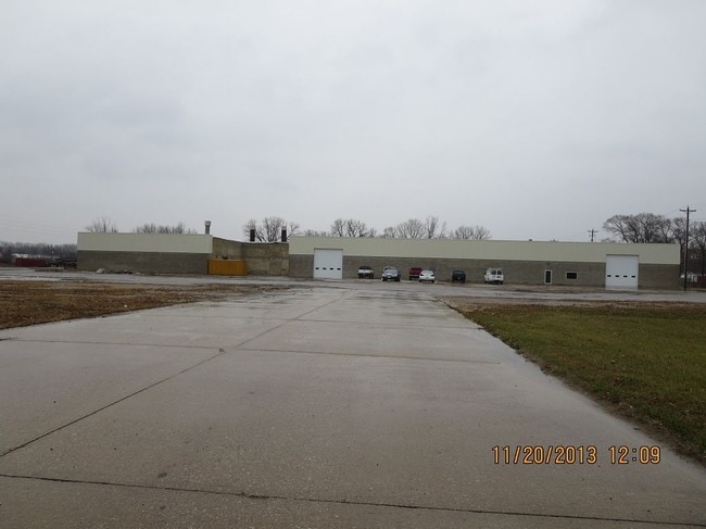
520 W Parker St, Waterloo, IA 50703


NEARBY LISTINGS FOR SALE OR LEASE
Property Detail
520 W Parker St
8913-14-401-001
Unplatted Wloo East
Warehouse
UNPLATTED WLOO EAST ALL THAT PT OF NW SE SEC 14 T 89 R 13 LYING N OF THE I C R R & SLY & WLY OF THE W C F & N R R EXC N 150
X
Black Hawk
19013C0188F
Iowa
2024
13.65 AC
2025
Iowa City/Waterloo
001701
Other Market Areas
49,920 SF
Waterloo-Cedar Falls, IA
DEMOGRAPHICS near 520 W Parker St
1 Mile
3 Mile
5 Mile
2024 Total Population
7,517
40,681
77,090
2029 Population
7,508
40,496
76,555
Pop Growth 2024-2029
(0.12%)
(0.45%)
(0.69%)
Average Age
38
38
39
2024 Total Households
3,054
17,117
33,422
HH Growth 2024-2029
(0.13%)
(0.41%)
(0.68%)
Median Household Inc
$35,521
$44,085
$53,472
Avg Household Size
2.30
2.30
2.20
2024 Avg HH Vehicles
2.00
2.00
2.00
Median Home Value
$68,402
$116,090
$143,463
Median Year Built
1950
1953
1961
Nearby Places
Map Layers
Map Styles
 Street
 Aerial
- Restaurants
- Banks
- Shops
- Fitness
- Groceries
SALE & LEASE HISTORY
LISTING DATE
SALE/LEASE

Mar 09, 2017
For Lease
Jul 05, 2018
For Lease
Nearby Properties
Address
Land Use
TOTAL SIZE
Lot Size
Zoning
Address
Land Use
TOTAL SIZE
Lot Size
Zoning
528,634 SF
13.33 AC
Address
Land Use
TOTAL SIZE
Lot Size
Zoning
9,719 SF
42.81 AC
Address
Land Use
TOTAL SIZE
Lot Size
Zoning
108,671 SF
3.72 AC
Address
Land Use
TOTAL SIZE
Lot Size
Zoning
186,130 SF
10.89 AC
Address
Land Use
TOTAL SIZE
Lot Size
Zoning
622 SF
106.81 AC
Address
Land Use
TOTAL SIZE
Lot Size
Zoning
341 SF
1.83 AC
Address
Land Use
TOTAL SIZE
Lot Size
Zoning
37,364 SF
10.78 AC
Address
Land Use
TOTAL SIZE
Lot Size
Zoning
101,633 SF
7 AC
Address
Land Use
TOTAL SIZE
Lot Size
Zoning
9,000 SF
21.25 AC
Address
Land Use
TOTAL SIZE
Lot Size
Zoning
7,140 SF
25.91 AC
Address
Land Use
TOTAL SIZE
Lot Size
Zoning
59,565 SF
0.28 AC
Address
Land Use
TOTAL SIZE
Lot Size
Zoning
115,819 SF
2.07 AC
Address
Land Use
TOTAL SIZE
Lot Size
Zoning
129,863 SF
11.40 AC
Address
Land Use
TOTAL SIZE
Lot Size
Zoning
125,340 SF
0.80 AC
Address
Land Use
TOTAL SIZE
Lot Size
Zoning
97,401 SF
21.83 AC
Address
Land Use
TOTAL SIZE
Lot Size
Zoning
60,496 SF
4.96 AC
Address
Land Use
TOTAL SIZE
Lot Size
Zoning
197,968 SF
6.10 AC
Address
Land Use
TOTAL SIZE
Lot Size
Zoning
41,999 SF
10.74 AC
Address
Land Use
TOTAL SIZE
Lot Size
Zoning
77,366 SF
38.51 AC
Address
Land Use
TOTAL SIZE
Lot Size
Zoning
18,000 SF
141.74 AC
Address
Land Use
TOTAL SIZE
Lot Size
Zoning
1,600 SF
9.51 AC
Address
Land Use
TOTAL SIZE
Lot Size
Zoning
10,016 SF
Address
Land Use
TOTAL SIZE
Lot Size
Zoning
76,644 SF
13.11 AC
Address
Land Use
TOTAL SIZE
Lot Size
Zoning
79,085 SF
1.79 AC
Address
Land Use
TOTAL SIZE
Lot Size
Zoning
47,141 SF
1.10 AC
Address
Land Use
TOTAL SIZE
Lot Size
Zoning
74,115 SF
10.60 AC
Address
Land Use
TOTAL SIZE
Lot Size
Zoning
131,874 SF
2.04 AC
Address
Land Use
TOTAL SIZE
Lot Size
Zoning
53,462 SF
1 AC
Address
Land Use
TOTAL SIZE
Lot Size
Zoning
8,168 SF
19 AC
Address
Land Use
TOTAL SIZE
Lot Size
Zoning
5.23 AC
The World's #1 Commercial Real Estate Marketplace
Connect with us
© 2026 CoStar Group
The information above has been obtained from sources believed reliable. While we do not doubt its accuracy we have not verified it and make no guarantee, warranty or representation about it. It is your responsibility to independently confirm its accuracy and completeness. Any projections, opinions, assumptions, or estimates used are for example only and do not represent the current or future performance of the property. The value of this transaction to you depends on tax and other factors which should be evaluated by your tax, financial, and legal advisors. You and your advisors should conduct a careful, independent investigation of the property to determine to your satisfaction the suitability of the property for your needs.