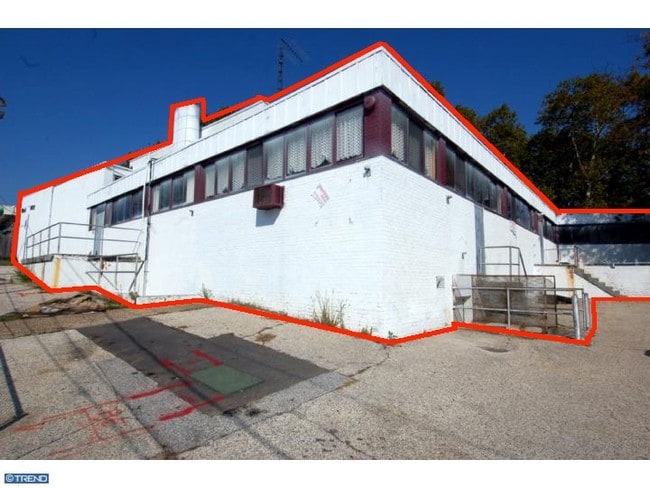
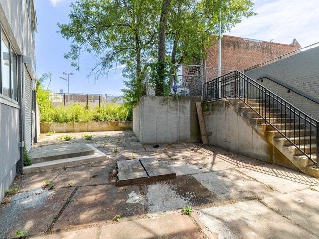
Property Record
520 W Roosevelt Blvd, Philadelphia, PA 19120
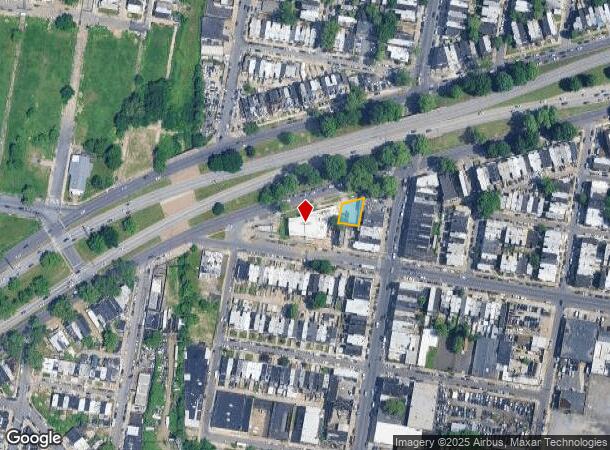

NEARBY LISTINGS FOR SALE OR LEASE
Property Detail
520 W Roosevelt Blvd
776257000
862 1/4 W OF 5 ST
Commercialnec
Philadelphia
X
Pennsylvania
42091C0395G
123
2024
0.31 AC
2026
Northeast Philadelphia
028700
Philadelphia
4,400 SF
Philadelphia-Camden-Wilmington, PA-NJ-DE-MD
DEMOGRAPHICS near 520 W Roosevelt Blvd
1 Mile
3 Mile
5 Mile
2024 Total Population
53,356
419,193
896,708
2029 Population
50,940
406,412
872,507
Pop Growth 2024-2029
(4.53%)
(3.05%)
(2.70%)
Average Age
37
37
38
2024 Total Households
18,668
156,936
357,056
HH Growth 2024-2029
(4.71%)
(3.20%)
(2.76%)
Median Household Inc
$33,582
$36,087
$50,491
Avg Household Size
2.70
2.50
2.40
2024 Avg HH Vehicles
1.00
1.00
1.00
Median Home Value
$97,756
$139,275
$199,281
Median Year Built
1946
1947
1949
Nearby Places
- Restaurants
- Banks
- Shops
- Fitness
- Groceries
PUBLIC TRANSPORTATION
TRANSIT/SUBWAY
Wyoming (Broad Street Line - Southeastern Pennsylvania Transportation Authority Rapid Transit (SEPTA Subway & Trolley))
DRIVE
WALK
Distance
Wyoming (Broad Street Line - Southeastern Pennsylvania Transportation Authority Rapid Transit (SEPTA Subway & Trolley))
2 min
15 min
0.8 mi
Hunting Park (Broad Street Line - Southeastern Pennsylvania Transportation Authority Rapid Transit (SEPTA Subway & Trolley))
DRIVE
WALK
Distance
Hunting Park (Broad Street Line - Southeastern Pennsylvania Transportation Authority Rapid Transit (SEPTA Subway & Trolley))
2 min
17 min
0.9 mi
COMMUTER RAIL
Olney (R8 - Southeastern Pennsylvania Transportation Authority Regional Rail (SEPTA Regional Rail))
DRIVE
WALK
Distance
Olney (R8 - Southeastern Pennsylvania Transportation Authority Regional Rail (SEPTA Regional Rail))
3 min
1.3 mi
Fern Rock Transportation Center (Lansdale/Doylestown Line - SEPTA, R1 - SEPTA, R2 - SEPTA, R3 - SEPTA, R5 - SEPTA, Warminster Line - SEPTA, West Trenton Line - SEPTA)
DRIVE
WALK
Distance
Fern Rock Transportation Center (Lansdale/Doylestown Line - SEPTA, R1 - SEPTA, R2 - SEPTA, R3 - SEPTA, R5 - SEPTA, Warminster Line - SEPTA, West Trenton Line - SEPTA)
4 min
1.4 mi
AIRPORT
Philadelphia International
DRIVE
WALK
Distance
Philadelphia International
30 min
17.3 mi
Trenton Mercer
DRIVE
WALK
Distance
Trenton Mercer
46 min
27.7 mi
Freight Ports
Port of Philadelphia
DRIVE
WALK
Distance
Port of Philadelphia
11 min
5.3 mi
SALE & LEASE HISTORY
LISTING DATE
SALE/LEASE

Sep 24, 2016
For Sale
Nearby Properties
Address
Land Use
TOTAL SIZE
Lot Size
Zoning
Address
Land Use
TOTAL SIZE
Lot Size
Zoning
455,889 SF
33 AC
I2
Address
Land Use
TOTAL SIZE
Lot Size
Zoning
520,280 SF
14.84 AC
RM3
Address
Land Use
TOTAL SIZE
Lot Size
Zoning
22,648 SF
38.69 AC
RM3
Address
Land Use
TOTAL SIZE
Lot Size
Zoning
485,616 SF
8.96 AC
CMX3
Address
Land Use
TOTAL SIZE
Lot Size
Zoning
242,655 SF
3.29 AC
CMX3
Address
Land Use
TOTAL SIZE
Lot Size
Zoning
425,535 SF
4.60 AC
RM3
Address
Land Use
TOTAL SIZE
Lot Size
Zoning
3,590 SF
50 AC
SPPOA
Address
Land Use
TOTAL SIZE
Lot Size
Zoning
121,578 SF
3.13 AC
RSA3
Address
Land Use
TOTAL SIZE
Lot Size
Zoning
587,330 SF
34.37 AC
SPINS
Address
Land Use
TOTAL SIZE
Lot Size
Zoning
287,286 SF
1.26 AC
CMX5
Address
Land Use
TOTAL SIZE
Lot Size
Zoning
17,886 SF
80 AC
SPPOA
Address
Land Use
TOTAL SIZE
Lot Size
Zoning
164,412 SF
4.44 AC
SPINS
Address
Land Use
TOTAL SIZE
Lot Size
Zoning
425,128 SF
23 AC
RSA5
Address
Land Use
TOTAL SIZE
Lot Size
Zoning
504,972 SF
16.30 AC
RM2
Address
Land Use
TOTAL SIZE
Lot Size
Zoning
500,000 SF
2.30 AC
CMX3
Address
Land Use
TOTAL SIZE
Lot Size
Zoning
218,030 SF
23.75 AC
CA2
Address
Land Use
TOTAL SIZE
Lot Size
Zoning
238,378 SF
18 AC
CA1
Address
Land Use
TOTAL SIZE
Lot Size
Zoning
293,734 SF
4.42 AC
ICMX
Address
Land Use
TOTAL SIZE
Lot Size
Zoning
235,276 SF
1.88 AC
CMX2.5
Address
Land Use
TOTAL SIZE
Lot Size
Zoning
2,500,000 SF
134.14 AC
I2
Address
Land Use
TOTAL SIZE
Lot Size
Zoning
561,600 SF
11.28 AC
CMX3
Address
Land Use
TOTAL SIZE
Lot Size
Zoning
75,358 SF
24.98 AC
I2
Address
Land Use
TOTAL SIZE
Lot Size
Zoning
237,834 SF
0.96 AC
CMX3
Address
Land Use
TOTAL SIZE
Lot Size
Zoning
1,316,610 SF
46.73 AC
I2
Address
Land Use
TOTAL SIZE
Lot Size
Zoning
208,620 SF
19.71 AC
I2
Address
Land Use
TOTAL SIZE
Lot Size
Zoning
210,964 SF
21.28 AC
CMX3
Address
Land Use
TOTAL SIZE
Lot Size
Zoning
526,165 SF
12.68 AC
RSA3
Address
Land Use
TOTAL SIZE
Lot Size
Zoning
249,388 SF
8.08 AC
RSA5
Address
Land Use
TOTAL SIZE
Lot Size
Zoning
363,136 SF
16.47 AC
RSA3
Address
Land Use
TOTAL SIZE
Lot Size
Zoning
233,143 SF
24.24 AC
SPINS
The World's #1 Commercial Real Estate Marketplace
Connect with us
© 2025 CoStar Group
The information above has been obtained from sources believed reliable. While we do not doubt its accuracy we have not verified it and make no guarantee, warranty or representation about it. It is your responsibility to independently confirm its accuracy and completeness. Any projections, opinions, assumptions, or estimates used are for example only and do not represent the current or future performance of the property. The value of this transaction to you depends on tax and other factors which should be evaluated by your tax, financial, and legal advisors. You and your advisors should conduct a careful, independent investigation of the property to determine to your satisfaction the suitability of the property for your needs.