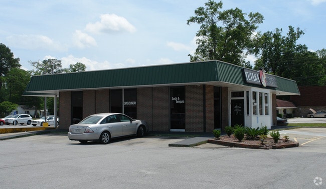
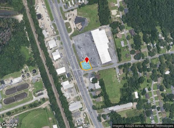
Property Record
5200 Augusta Rd, Savannah, GA 31408

NEARBY LISTINGS FOR SALE OR LEASE
Property Detail
5200 Augusta Rd
Savannah, GA
Sub
6000202040
LOT II SUB OF THE EASTERN PT OF LOTS 1, 2, 3, 4 OF A RESUB OF L
Restaurantbuilding
Chatham
X
Georgia
13051C0135H
1-4
2024
0.24 AC
2025
N Savannah/Garden City
010601
Savannah
1,880 SF
DEMOGRAPHICS near 5200 Augusta Rd
1 Mile
3 Mile
5 Mile
2024 Total Population
2,479
10,813
38,912
2029 Population
2,553
11,223
40,759
Pop Growth 2024-2029
+ 2.99%
+ 3.79%
+ 4.75%
Average Age
42
40
37
2024 Total Households
987
4,268
13,346
HH Growth 2024-2029
+ 3.14%
+ 3.94%
+ 5.39%
Median Household Inc
$42,853
$50,494
$45,208
Avg Household Size
2.50
2.40
2.40
2024 Avg HH Vehicles
2.00
2.00
2.00
Median Home Value
$150,000
$144,480
$141,648
Median Year Built
1964
1969
1976
Nearby Places
Map Layers
Map Styles
 Street
 Aerial
- Restaurants
- Banks
- Shops
- Fitness
- Groceries
PUBLIC TRANSPORTATION
COMMUTER RAIL
DRIVE
WALK
Distance
11 min
4.9 mi
AIRPORT
Savannah/Hilton Head International
DRIVE
WALK
Distance
Savannah/Hilton Head International
11 min
4.2 mi
Hilton Head
DRIVE
WALK
Distance
Hilton Head
57 min
42.1 mi
SALE & LEASE HISTORY
LISTING DATE
SALE/LEASE

Oct 31, 2018
For Sale
Aug 16, 2022
For Sale
Nearby Properties
Address
Land Use
TOTAL SIZE
Lot Size
Zoning
Address
Land Use
TOTAL SIZE
Lot Size
Zoning
1,115,200 SF
81.30 AC
Address
Land Use
TOTAL SIZE
Lot Size
Zoning
7,500 SF
382.12 AC
I-H
Address
Land Use
TOTAL SIZE
Lot Size
Zoning
588,726 SF
0.30 AC
I-L
Address
Land Use
TOTAL SIZE
Lot Size
Zoning
40,848 SF
19.50 AC
RIN
Address
Land Use
TOTAL SIZE
Lot Size
Zoning
9,505 SF
0.07 AC
Address
Land Use
TOTAL SIZE
Lot Size
Zoning
285,905 SF
20.16 AC
I-L
Address
Land Use
TOTAL SIZE
Lot Size
Zoning
29.50 AC
IL
Address
Land Use
TOTAL SIZE
Lot Size
Zoning
20,210 SF
85.60 AC
I-H
Address
Land Use
TOTAL SIZE
Lot Size
Zoning
515,800 SF
36.16 AC
Address
Land Use
TOTAL SIZE
Lot Size
Zoning
3,648 SF
66.30 AC
I-L
Address
Land Use
TOTAL SIZE
Lot Size
Zoning
44,940 SF
388 AC
I-H
Address
Land Use
TOTAL SIZE
Lot Size
Zoning
330,900 SF
41.50 AC
I-1
Address
Land Use
TOTAL SIZE
Lot Size
Zoning
495,600 SF
35.64 AC
I-H
Address
Land Use
TOTAL SIZE
Lot Size
Zoning
8,100 SF
428.50 AC
I-H
Address
Land Use
TOTAL SIZE
Lot Size
Zoning
10,032 SF
100 AC
I-H
Address
Land Use
TOTAL SIZE
Lot Size
Zoning
392,099 SF
20 AC
I-H
Address
Land Use
TOTAL SIZE
Lot Size
Zoning
12,150 SF
23.76 AC
Address
Land Use
TOTAL SIZE
Lot Size
Zoning
18,483 SF
71.98 AC
Address
Land Use
TOTAL SIZE
Lot Size
Zoning
321,550 SF
34 AC
IH
Address
Land Use
TOTAL SIZE
Lot Size
Zoning
251,630 SF
20.78 AC
M
Address
Land Use
TOTAL SIZE
Lot Size
Zoning
314,100 SF
14.50 AC
I-1
Address
Land Use
TOTAL SIZE
Lot Size
Zoning
311,400 SF
33.80 AC
I-H
Address
Land Use
TOTAL SIZE
Lot Size
Zoning
325,500 SF
22.29 AC
I-1
Address
Land Use
TOTAL SIZE
Lot Size
Zoning
304,675 SF
19.40 AC
I-H
Address
Land Use
TOTAL SIZE
Lot Size
Zoning
315,980 SF
25.95 AC
I-H
Address
Land Use
TOTAL SIZE
Lot Size
Zoning
348,000 SF
17.07 AC
I-1
Address
Land Use
TOTAL SIZE
Lot Size
Zoning
304,000 SF
17.02 AC
I-H
Address
Land Use
TOTAL SIZE
Lot Size
Zoning
249,600 SF
16.74 AC
I-1
Address
Land Use
TOTAL SIZE
Lot Size
Zoning
248,000 SF
15.86 AC
I-H
Address
Land Use
TOTAL SIZE
Lot Size
Zoning
16,650 SF
55.95 AC
I-L
The World's #1 Commercial Real Estate Marketplace
Connect with us
© 2025 CoStar Group
The information above has been obtained from sources believed reliable. While we do not doubt its accuracy we have not verified it and make no guarantee, warranty or representation about it. It is your responsibility to independently confirm its accuracy and completeness. Any projections, opinions, assumptions, or estimates used are for example only and do not represent the current or future performance of the property. The value of this transaction to you depends on tax and other factors which should be evaluated by your tax, financial, and legal advisors. You and your advisors should conduct a careful, independent investigation of the property to determine to your satisfaction the suitability of the property for your needs.