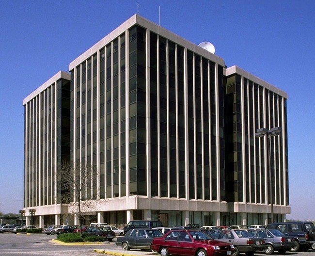
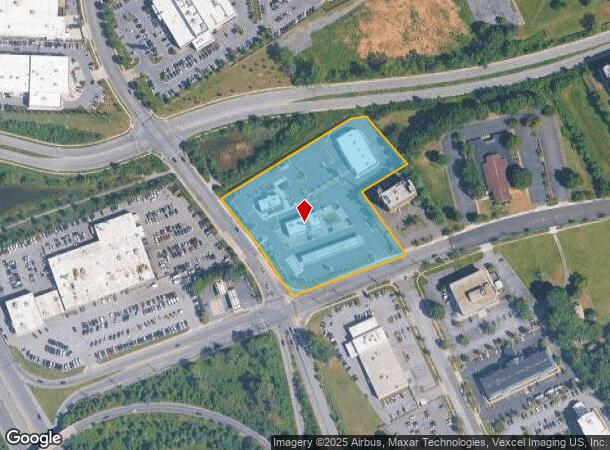
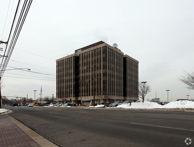
Property Record
5200 Auth Rd, Suitland, MD 20746

NEARBY LISTINGS FOR SALE OR LEASE
Property Detail
5200 Auth Rd
06-0420463
Parcel F Auth Road Center
Restaurantdrivein
PT PAR F
X
Prince George's
24033C0235E
Maryland
2024
3.83 AC
2025
Branch Avenue Corridor
801905
Washington, DC
15,643 SF
Washington-Arlington-Alexandria, DC-VA-MD-WV
DEMOGRAPHICS near 5200 Auth Rd
1 Mile
3 Mile
5 Mile
2024 Total Population
8,188
107,751
325,866
2029 Population
8,019
105,004
310,928
Pop Growth 2024-2029
(2.06%)
(2.55%)
(4.58%)
Average Age
40
40
39
2024 Total Households
3,680
43,829
128,612
HH Growth 2024-2029
(2.12%)
(2.63%)
(5.02%)
Median Household Inc
$94,700
$72,549
$65,726
Avg Household Size
2.20
2.40
2.40
2024 Avg HH Vehicles
2.00
2.00
1.00
Median Home Value
$331,395
$314,920
$338,886
Median Year Built
1994
1969
1967
Nearby Places
Map Layers
Map Styles
 Street
 Aerial
- Restaurants
- Banks
- Shops
- Fitness
- Groceries
PUBLIC TRANSPORTATION
COMMUTER RAIL
Union Station (Red Line - Washington Metropolitan Area Transit Authority Metrorail (Metrorail))
DRIVE
WALK
Distance
Union Station (Red Line - Washington Metropolitan Area Transit Authority Metrorail (Metrorail))
18 min
8.0 mi
DRIVE
WALK
Distance
18 min
8.4 mi
AIRPORT
Ronald Reagan Washington Ntl
DRIVE
WALK
Distance
Ronald Reagan Washington Ntl
25 min
13.2 mi
Baltimore/Washington International Thurgood Marshall
DRIVE
WALK
Distance
Baltimore/Washington International Thurgood Marshall
53 min
36.3 mi
Washington Dulles International
DRIVE
WALK
Distance
Washington Dulles International
61 min
40.2 mi
Freight Ports
Port of Baltimore
DRIVE
WALK
Distance
Port of Baltimore
62 min
42.6 mi
SALE & LEASE HISTORY
LISTING DATE
SALE/LEASE

Sep 24, 2016
For Sale
Dec 13, 2018
For Lease
Aug 30, 2017
For Lease
Nearby Properties
Address
Land Use
TOTAL SIZE
Lot Size
Zoning
Address
Land Use
TOTAL SIZE
Lot Size
Zoning
2,131,229 SF
144.34 AC
AG
Address
Land Use
TOTAL SIZE
Lot Size
Zoning
963,250 SF
10.71 AC
RTOLE
Address
Land Use
TOTAL SIZE
Lot Size
Zoning
417 SF
7.66 AC
RTOLE
Address
Land Use
TOTAL SIZE
Lot Size
Zoning
26.64 AC
RMF20
Address
Land Use
TOTAL SIZE
Lot Size
Zoning
203.33 AC
IE
Address
Land Use
TOTAL SIZE
Lot Size
Zoning
450 SF
20.72 AC
RMF20
Address
Land Use
TOTAL SIZE
Lot Size
Zoning
6 AC
RTOLE
Address
Land Use
TOTAL SIZE
Lot Size
Zoning
111.87 AC
IE
Address
Land Use
TOTAL SIZE
Lot Size
Zoning
98.14 AC
IE
Address
Land Use
TOTAL SIZE
Lot Size
Zoning
29.24 AC
RMF20
Address
Land Use
TOTAL SIZE
Lot Size
Zoning
73.26 AC
IE
Address
Land Use
TOTAL SIZE
Lot Size
Zoning
262 SF
24.86 AC
RMF20
Address
Land Use
TOTAL SIZE
Lot Size
Zoning
701 SF
29.42 AC
RMF20
Address
Land Use
TOTAL SIZE
Lot Size
Zoning
450 SF
21.14 AC
RMF20
Address
Land Use
TOTAL SIZE
Lot Size
Zoning
29.49 AC
RSFA
Address
Land Use
TOTAL SIZE
Lot Size
Zoning
17.90 AC
RMF20
Address
Land Use
TOTAL SIZE
Lot Size
Zoning
21.48 AC
RMF20
Address
Land Use
TOTAL SIZE
Lot Size
Zoning
22.67 AC
RMF20
Address
Land Use
TOTAL SIZE
Lot Size
Zoning
17.08 AC
RMF20
Address
Land Use
TOTAL SIZE
Lot Size
Zoning
245,767 SF
13.88 AC
CGO
Address
Land Use
TOTAL SIZE
Lot Size
Zoning
11.82 AC
RMF20
Address
Land Use
TOTAL SIZE
Lot Size
Zoning
15.65 AC
RMF20
Address
Land Use
TOTAL SIZE
Lot Size
Zoning
238,785 SF
12.79 AC
CGO
Address
Land Use
TOTAL SIZE
Lot Size
Zoning
124.59 AC
IE
Address
Land Use
TOTAL SIZE
Lot Size
Zoning
13.74 AC
RMF20
Address
Land Use
TOTAL SIZE
Lot Size
Zoning
4,059 SF
16.82 AC
IE
Address
Land Use
TOTAL SIZE
Lot Size
Zoning
133,840 SF
33.35 AC
IE
Address
Land Use
TOTAL SIZE
Lot Size
Zoning
74.38 AC
IE
Address
Land Use
TOTAL SIZE
Lot Size
Zoning
90,485 SF
18.05 AC
RSF65
Address
Land Use
TOTAL SIZE
Lot Size
Zoning
2,015 SF
9.64 AC
LTOC
The World's #1 Commercial Real Estate Marketplace
Connect with us
© 2026 CoStar Group
The information above has been obtained from sources believed reliable. While we do not doubt its accuracy we have not verified it and make no guarantee, warranty or representation about it. It is your responsibility to independently confirm its accuracy and completeness. Any projections, opinions, assumptions, or estimates used are for example only and do not represent the current or future performance of the property. The value of this transaction to you depends on tax and other factors which should be evaluated by your tax, financial, and legal advisors. You and your advisors should conduct a careful, independent investigation of the property to determine to your satisfaction the suitability of the property for your needs.