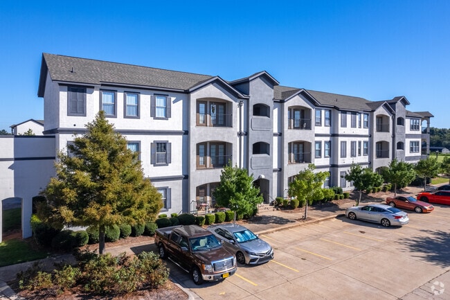
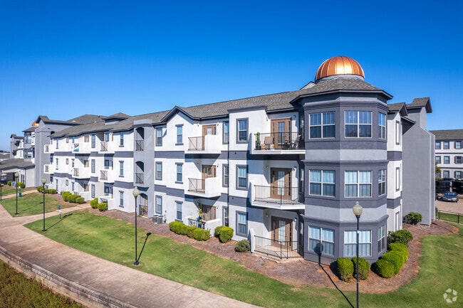
Property Record
5200 E Texas St, Haughton, LA 71037

Current Lease Availabilities
Property Detail
5200 E Texas St
Shreveport-Bossier City, LA
FROM THE NE CORNER OF LOT 2 BRANDON SQUARE SUBDV SAID PT BEING ON THE SLY R/W LINE OF US HWY 80 PROCEED N 69 DEG 28 MIN 34 SE
166038
BOSSIER
Commercialnec
Louisiana
B and X Area of moderate flood hazard, usually the area between the limits of the 100-year and 500-year floods.
2
2024
10 AC
2024
North Bossier
011113
Shreveport/Bossier City
255 SF
NEARBY LISTINGS FOR SALE OR LEASE
-
-
View all Haughton listings for lease on LoopNet.com
DEMOGRAPHICS near 5200 E Texas St
1 mile
3 mile
5 mile
2025 Total Population
4,724
26,867
76,109
2030 Population
4,773
27,232
76,873
Pop Growth 2025-2030
+ 1.04%
+ 1.36%
+ 1.00%
Average Age
37
37
38
2025 Total Households
1,956
10,797
31,495
HH Growth 2025-2030
+ 1.38%
+ 1.57%
+ 1.11%
Median Household Inc
$44,119
$55,739
$58,817
Avg Household Size
2.30
2.40
2.30
2025 Avg HH Vehicles
2.00
2.00
2.00
Median Home Value
$93,152
$170,822
$190,846
Median Year Built
1981
1980
1980
Nearby Places
Map Layers
Map Styles
 Street
 Aerial
Transit
 Traffic
 Biking
Places
Listings with unknown addresses are not visible on the map
- Restaurants
- Banks
- Shops
- Fitness
- Groceries
PUBLIC TRANSPORTATION
AIRPORT
Shreveport Regional
Drive
Walk
Distance
Shreveport Regional
26 min
14.2 mi
Freight Ports
Port of Shreveport
Drive
Walk
Distance
Port of Shreveport
30 min
18.2 mi
Nearby Properties
Address
Land Use
TOTAL SIZE
Lot Size
Zoning
Address
Land Use
TOTAL SIZE
Lot Size
Zoning
1,700 SF
28 AC
Address
Land Use
TOTAL SIZE
Lot Size
Zoning
601,879 SF
269 AC
Address
Land Use
TOTAL SIZE
Lot Size
Zoning
49,550 SF
65 AC
Address
Land Use
TOTAL SIZE
Lot Size
Zoning
133,198 SF
54 AC
Address
Land Use
TOTAL SIZE
Lot Size
Zoning
222,616 SF
0.28 AC
Address
Land Use
TOTAL SIZE
Lot Size
Zoning
70,590 SF
28 AC
Address
Land Use
TOTAL SIZE
Lot Size
Zoning
107,841 SF
2 AC
Address
Land Use
TOTAL SIZE
Lot Size
Zoning
110,252 SF
18.86 AC
Address
Land Use
TOTAL SIZE
Lot Size
Zoning
205,616 SF
0.63 AC
Address
Land Use
TOTAL SIZE
Lot Size
Zoning
5,262 SF
16 AC
Address
Land Use
TOTAL SIZE
Lot Size
Zoning
10,080 SF
12 AC
Address
Land Use
TOTAL SIZE
Lot Size
Zoning
76,700 SF
15.47 AC
Address
Land Use
TOTAL SIZE
Lot Size
Zoning
82,547 SF
17 AC
Address
Land Use
TOTAL SIZE
Lot Size
Zoning
133,742 SF
16.62 AC
Address
Land Use
TOTAL SIZE
Lot Size
Zoning
72,696 SF
15 AC
Address
Land Use
TOTAL SIZE
Lot Size
Zoning
36,443 SF
Address
Land Use
TOTAL SIZE
Lot Size
Zoning
44,578 SF
11.44 AC
Address
Land Use
TOTAL SIZE
Lot Size
Zoning
310,529 SF
5 AC
Address
Land Use
TOTAL SIZE
Lot Size
Zoning
84,000 SF
3 AC
Address
Land Use
TOTAL SIZE
Lot Size
Zoning
59,300 SF
14.23 AC
Address
Land Use
TOTAL SIZE
Lot Size
Zoning
39,268 SF
15 AC
Address
Land Use
TOTAL SIZE
Lot Size
Zoning
107,700 SF
13 AC
Address
Land Use
TOTAL SIZE
Lot Size
Zoning
114,040 SF
11.49 AC
Address
Land Use
TOTAL SIZE
Lot Size
Zoning
57,035 SF
4.03 AC
Address
Land Use
TOTAL SIZE
Lot Size
Zoning
65,942 SF
10 AC
Address
Land Use
TOTAL SIZE
Lot Size
Zoning
100,000 SF
5.88 AC
Address
Land Use
TOTAL SIZE
Lot Size
Zoning
53,530 SF
3.76 AC
Address
Land Use
TOTAL SIZE
Lot Size
Zoning
3,300 SF
Address
Land Use
TOTAL SIZE
Lot Size
Zoning
42,294 SF
5.86 AC
The World's #1 Commercial Real Estate Marketplace
Connect with us
© 2026 CoStar Group
The information above has been obtained from sources believed reliable. While we do not doubt its accuracy we have not verified it and make no guarantee, warranty or representation about it. It is your responsibility to independently confirm its accuracy and completeness. Any projections, opinions, assumptions, or estimates used are for example only and do not represent the current or future performance of the property. The value of this transaction to you depends on tax and other factors which should be evaluated by your tax, financial, and legal advisors. You and your advisors should conduct a careful, independent investigation of the property to determine to your satisfaction the suitability of the property for your needs.