Property Record
5200 Front Range Pky, Watkins, CO 80137

Property Detail
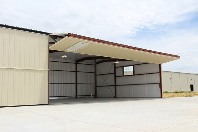
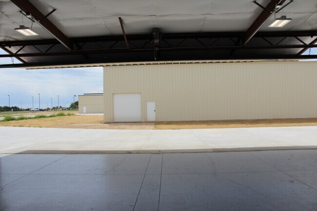
5200 Front Range Pky
1817-00-0-00-231
SECT,TWN,RNG:16-3-64 DESC: N2 EXC PT PLATTED 319/19A
Taxexempt
Adams
AV
Colorado
B and X Area of moderate flood hazard, usually the area between the limits of the 100-year and 500-year floods.
319.19 AC
0
Northeast Denver
2025
Denver
008401
Denver-Aurora-Centennial, CO
35,720 SF
NEARBY LISTINGS FOR SALE OR LEASE
DEMOGRAPHICS near 5200 Front Range Pky
1 mile
3 mile
5 mile
2025 Total Population
8
73
1,348
2030 Population
8
75
1,408
Pop Growth 2025-2030
0.00%
+ 2.74%
+ 4.45%
Average Age
46
42
41
2025 Total Households
3
25
448
HH Growth 2025-2030
0.00%
+ 4.00%
+ 4.02%
Median Household Inc
$137,500
$120,833
$120,974
Avg Household Size
2.00
2.90
3.00
2025 Avg HH Vehicles
4.00
3.00
3.00
Median Home Value
$750,000
$683,333
$724,169
Median Year Built
1989
1992
1995
Nearby Places
Map Layers
Map Styles
 Street
 Aerial
Transit
 Traffic
 Biking
Places
Listings with unknown addresses are not visible on the map
- Restaurants
- Banks
- Shops
- Fitness
- Groceries
PUBLIC TRANSPORTATION
AIRPORT
Denver International
Drive
Walk
Distance
Denver International
23 min
14.0 mi
Freight Ports
Tulsa Port Of Catoosa
Drive
Walk
Distance
Tulsa Port Of Catoosa
708 min
687.3 mi
SALE & LEASE HISTORY
LISTING DATE
SALE/LEASE

Jun 04, 2020
For Sale
Nearby Properties
Address
Land Use
TOTAL SIZE
Lot Size
Zoning
Address
Land Use
TOTAL SIZE
Lot Size
Zoning
320 AC
AV
Address
Land Use
TOTAL SIZE
Lot Size
Zoning
291.65 AC
Address
Land Use
TOTAL SIZE
Lot Size
Zoning
Address
Land Use
TOTAL SIZE
Lot Size
Zoning
39.98 AC
Address
Land Use
TOTAL SIZE
Lot Size
Zoning
Address
Land Use
TOTAL SIZE
Lot Size
Zoning
Address
Land Use
TOTAL SIZE
Lot Size
Zoning
Address
Land Use
TOTAL SIZE
Lot Size
Zoning
4,950 SF
320 AC
AV
Address
Land Use
TOTAL SIZE
Lot Size
Zoning
80 AC
AV
Address
Land Use
TOTAL SIZE
Lot Size
Zoning
28,800 SF
55.13 AC
AV
Address
Land Use
TOTAL SIZE
Lot Size
Zoning
10,508 SF
44.75 AC
AV
Address
Land Use
TOTAL SIZE
Lot Size
Zoning
4.70 AC
Address
Land Use
TOTAL SIZE
Lot Size
Zoning
70.53 AC
AV
Address
Land Use
TOTAL SIZE
Lot Size
Zoning
28,130 SF
0.90 AC
AV
Address
Land Use
TOTAL SIZE
Lot Size
Zoning
27,650 SF
0.90 AC
AV
Address
Land Use
TOTAL SIZE
Lot Size
Zoning
15,484 SF
0.18 AC
Address
Land Use
TOTAL SIZE
Lot Size
Zoning
15,120 SF
80 AC
AV
Address
Land Use
TOTAL SIZE
Lot Size
Zoning
34,400 SF
0.86 AC
AV
Address
Land Use
TOTAL SIZE
Lot Size
Zoning
14,994 SF
0.58 AC
AV
Address
Land Use
TOTAL SIZE
Lot Size
Zoning
8,000 SF
0.19 AC
AV
Address
Land Use
TOTAL SIZE
Lot Size
Zoning
14,996 SF
0.58 AC
AV
Address
Land Use
TOTAL SIZE
Lot Size
Zoning
10,000 SF
320 AC
AV
Address
Land Use
TOTAL SIZE
Lot Size
Zoning
8,250 SF
80 AC
AV
Address
Land Use
TOTAL SIZE
Lot Size
Zoning
14,896 SF
80 AC
AV
Address
Land Use
TOTAL SIZE
Lot Size
Zoning
13,440 SF
0.33 AC
AV
Address
Land Use
TOTAL SIZE
Lot Size
Zoning
10,000 SF
320 AC
AV
Address
Land Use
TOTAL SIZE
Lot Size
Zoning
10,000 SF
320 AC
AV
Address
Land Use
TOTAL SIZE
Lot Size
Zoning
13,440 SF
0.58 AC
AV
Address
Land Use
TOTAL SIZE
Lot Size
Zoning
15,484 SF
0.18 AC
The World's #1 Commercial Real Estate Marketplace
Connect with us
© 2026 CoStar Group
The information above has been obtained from sources believed reliable. While we do not doubt its accuracy we have not verified it and make no guarantee, warranty or representation about it. It is your responsibility to independently confirm its accuracy and completeness. Any projections, opinions, assumptions, or estimates used are for example only and do not represent the current or future performance of the property. The value of this transaction to you depends on tax and other factors which should be evaluated by your tax, financial, and legal advisors. You and your advisors should conduct a careful, independent investigation of the property to determine to your satisfaction the suitability of the property for your needs.