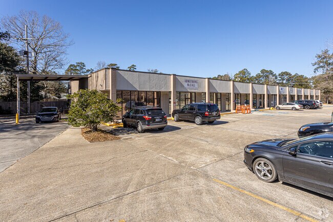
Property Record
5200 Highway 22, Mandeville, LA 70471

NEARBY LISTINGS FOR SALE OR LEASE
Property Detail
5200 Highway 22
53150
Commercial Hwy 22 Ward 4
Commercialnec
TRACT B2 WOODRIDGE ON THE LAKE PH 3 INST NO 1284843 INST NO 1343407 INST NO 1517906 INST NO 1917576
ARE
St Tammany
2202020313D
Louisiana
2025
1.20 AC
2024
Mandeville/Covington
040307
New Orleans/Metairie/Kenner
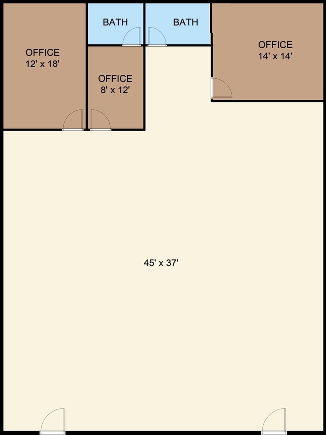
16,355 SF
Slidell-Mandeville-Covington, LA
DEMOGRAPHICS near 5200 Highway 22
1 mile
3 mile
5 mile
2024 Total Population
7,151
31,168
73,051
2029 Population
7,637
33,471
78,474
Pop Growth 2024-2029
+ 6.80%
+ 7.39%
+ 7.42%
Average Age
42
42
42
2024 Total Households
2,775
12,331
28,858
HH Growth 2024-2029
+ 6.74%
+ 7.41%
+ 7.43%
Median Household Inc
$91,921
$89,380
$84,511
Avg Household Size
2.50
2.50
2.50
2024 Avg HH Vehicles
2.00
2.00
2.00
Median Home Value
$371,527
$381,958
$340,845
Median Year Built
1990
1994
1996
Nearby Places
Map Layers
Map Styles
 Street
 Aerial
Transit
 Traffic
 Biking
Places
Listings with unknown addresses are not visible on the map
- Restaurants
- Banks
- Shops
- Fitness
- Groceries
PUBLIC TRANSPORTATION
AIRPORT
Louis Armstrong New Orleans International
Drive
Walk
Distance
Louis Armstrong New Orleans International
51 min
37.3 mi
SALE & LEASE HISTORY
LISTING DATE
SALE/LEASE

Nov 23, 2020
For Lease
Nov 19, 2019
For Sale
Feb 22, 2021
For Lease
Feb 18, 2020
For Lease
Nearby Properties
Address
Land Use
TOTAL SIZE
Lot Size
Zoning
Address
Land Use
TOTAL SIZE
Lot Size
Zoning
13.36 AC
Address
Land Use
TOTAL SIZE
Lot Size
Zoning
285,406 SF
Address
Land Use
TOTAL SIZE
Lot Size
Zoning
278,202 SF
12.04 AC
Address
Land Use
TOTAL SIZE
Lot Size
Zoning
178,608 SF
34.02 AC
Address
Land Use
TOTAL SIZE
Lot Size
Zoning
277,159 SF
55.30 AC
Address
Land Use
TOTAL SIZE
Lot Size
Zoning
268,040 SF
12.34 AC
Address
Land Use
TOTAL SIZE
Lot Size
Zoning
24.12 AC
Address
Land Use
TOTAL SIZE
Lot Size
Zoning
269,202 SF
13.66 AC
Address
Land Use
TOTAL SIZE
Lot Size
Zoning
164,430 SF
6.32 AC
Address
Land Use
TOTAL SIZE
Lot Size
Zoning
229,994 SF
30 AC
Address
Land Use
TOTAL SIZE
Lot Size
Zoning
168,000 SF
10 AC
Address
Land Use
TOTAL SIZE
Lot Size
Zoning
220,860 SF
25.07 AC
Address
Land Use
TOTAL SIZE
Lot Size
Zoning
190,885 SF
9.45 AC
Address
Land Use
TOTAL SIZE
Lot Size
Zoning
154,751 SF
14.96 AC
Address
Land Use
TOTAL SIZE
Lot Size
Zoning
147,767 SF
35.97 AC
Address
Land Use
TOTAL SIZE
Lot Size
Zoning
165,168 SF
18.16 AC
Address
Land Use
TOTAL SIZE
Lot Size
Zoning
66,500 SF
4.35 AC
Address
Land Use
TOTAL SIZE
Lot Size
Zoning
57,360 SF
2.77 AC
Address
Land Use
TOTAL SIZE
Lot Size
Zoning
82,796 SF
19.47 AC
Address
Land Use
TOTAL SIZE
Lot Size
Zoning
107,727 SF
2.69 AC
Address
Land Use
TOTAL SIZE
Lot Size
Zoning
113,686 SF
10.34 AC
Address
Land Use
TOTAL SIZE
Lot Size
Zoning
139,485 SF
16.60 AC
Address
Land Use
TOTAL SIZE
Lot Size
Zoning
130,535 SF
9.63 AC
Address
Land Use
TOTAL SIZE
Lot Size
Zoning
54,226 SF
5.10 AC
Address
Land Use
TOTAL SIZE
Lot Size
Zoning
93,800 SF
10.35 AC
Address
Land Use
TOTAL SIZE
Lot Size
Zoning
206,403 SF
9.06 AC
Address
Land Use
TOTAL SIZE
Lot Size
Zoning
50,560 SF
6.32 AC
Address
Land Use
TOTAL SIZE
Lot Size
Zoning
56,162 SF
5.30 AC
Address
Land Use
TOTAL SIZE
Lot Size
Zoning
48,866 SF
2.21 AC
Address
Land Use
TOTAL SIZE
Lot Size
Zoning
77,388 SF
7.57 AC
The World's #1 Commercial Real Estate Marketplace
Connect with us
© 2026 CoStar Group
The information above has been obtained from sources believed reliable. While we do not doubt its accuracy we have not verified it and make no guarantee, warranty or representation about it. It is your responsibility to independently confirm its accuracy and completeness. Any projections, opinions, assumptions, or estimates used are for example only and do not represent the current or future performance of the property. The value of this transaction to you depends on tax and other factors which should be evaluated by your tax, financial, and legal advisors. You and your advisors should conduct a careful, independent investigation of the property to determine to your satisfaction the suitability of the property for your needs.