Property Record
5200 Hoffman St, Elkhart, IN 46516
NEARBY LISTINGS FOR SALE OR LEASE
Property Detail
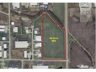
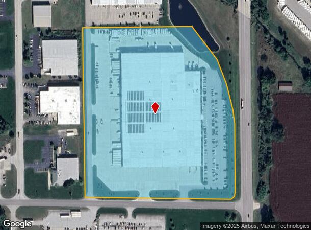
5200 Hoffman St
Elkhart-Goshen, IN
Cr 17 Land Development Major Sub First
20-06-01-277-004.000-011
CR 17 LAND DEVELOPMENT MAJOR SUB FIRST REPLAT LOT 2A 18.45A
Warehouse
Elkhart
AE
Indiana
18039C0134D
2a
2024
18.45 AC
2025
Outlying Elkhart County
001902
South Bend/Mishawaka
276,920 SF
DEMOGRAPHICS near 5200 Hoffman St
1 Mile
3 Mile
5 Mile
2024 Total Population
639
24,776
79,021
2029 Population
652
24,724
79,138
Pop Growth 2024-2029
+ 2.03%
(0.21%)
+ 0.15%
Average Age
37
40
38
2024 Total Households
224
9,536
29,268
HH Growth 2024-2029
+ 1.79%
(0.23%)
+ 0.20%
Median Household Inc
$55,543
$68,213
$57,237
Avg Household Size
2.80
2.60
2.60
2024 Avg HH Vehicles
2.00
2.00
2.00
Median Home Value
$202,885
$191,821
$163,196
Median Year Built
1988
1982
1975
Nearby Places
Map Layers
Map Styles
 Street
 Aerial
- Restaurants
- Banks
- Shops
- Fitness
- Groceries
PUBLIC TRANSPORTATION
COMMUTER RAIL
DRIVE
WALK
Distance
11 min
5.0 mi
AIRPORT
South Bend International
DRIVE
WALK
Distance
South Bend International
48 min
30.5 mi
Nearby Properties
Address
Land Use
TOTAL SIZE
Lot Size
Zoning
Address
Land Use
TOTAL SIZE
Lot Size
Zoning
499,680 SF
36.76 AC
Address
Land Use
TOTAL SIZE
Lot Size
Zoning
863,219 SF
25.67 AC
M-2
Address
Land Use
TOTAL SIZE
Lot Size
Zoning
351,795 SF
82.33 AC
ZO01
Address
Land Use
TOTAL SIZE
Lot Size
Zoning
316,104 SF
71.01 AC
ZO01
Address
Land Use
TOTAL SIZE
Lot Size
Zoning
504,647 SF
21.55 AC
ZO01
Address
Land Use
TOTAL SIZE
Lot Size
Zoning
162,380 SF
20.94 AC
ZO01
Address
Land Use
TOTAL SIZE
Lot Size
Zoning
349,560 SF
31.17 AC
Address
Land Use
TOTAL SIZE
Lot Size
Zoning
338,388 SF
36.41 AC
ZO01
Address
Land Use
TOTAL SIZE
Lot Size
Zoning
276,377 SF
29.49 AC
ZO01
Address
Land Use
TOTAL SIZE
Lot Size
Zoning
184,185 SF
38.12 AC
ZO01
Address
Land Use
TOTAL SIZE
Lot Size
Zoning
173,088 SF
26.34 AC
ZO01
Address
Land Use
TOTAL SIZE
Lot Size
Zoning
355,938 SF
20.72 AC
Address
Land Use
TOTAL SIZE
Lot Size
Zoning
289,195 SF
48.88 AC
ZO01
Address
Land Use
TOTAL SIZE
Lot Size
Zoning
81,272 SF
32.51 AC
ZO01
Address
Land Use
TOTAL SIZE
Lot Size
Zoning
244,703 SF
25.03 AC
ZO01
Address
Land Use
TOTAL SIZE
Lot Size
Zoning
238,198 SF
11.18 AC
ZO01
Address
Land Use
TOTAL SIZE
Lot Size
Zoning
356,836 SF
27.94 AC
Address
Land Use
TOTAL SIZE
Lot Size
Zoning
284,569 SF
22.37 AC
ZO01
Address
Land Use
TOTAL SIZE
Lot Size
Zoning
227,288 SF
11.12 AC
Address
Land Use
TOTAL SIZE
Lot Size
Zoning
207,360 SF
12.27 AC
ZO01
Address
Land Use
TOTAL SIZE
Lot Size
Zoning
135,000 SF
21.30 AC
ZO01
Address
Land Use
TOTAL SIZE
Lot Size
Zoning
173,015 SF
15.41 AC
ZO01
Address
Land Use
TOTAL SIZE
Lot Size
Zoning
212,960 SF
10 AC
ZO01
Address
Land Use
TOTAL SIZE
Lot Size
Zoning
199,800 SF
13 AC
ZO01
Address
Land Use
TOTAL SIZE
Lot Size
Zoning
220,827 SF
11.76 AC
Address
Land Use
TOTAL SIZE
Lot Size
Zoning
246,553 SF
22.11 AC
ZO01
Address
Land Use
TOTAL SIZE
Lot Size
Zoning
107,219 SF
6.46 AC
ZO01
Address
Land Use
TOTAL SIZE
Lot Size
Zoning
129,688 SF
43.60 AC
ZO01
Address
Land Use
TOTAL SIZE
Lot Size
Zoning
83,770 SF
16.07 AC
ZO01
The World's #1 Commercial Real Estate Marketplace
Connect with us
© 2025 CoStar Group
The information above has been obtained from sources believed reliable. While we do not doubt its accuracy we have not verified it and make no guarantee, warranty or representation about it. It is your responsibility to independently confirm its accuracy and completeness. Any projections, opinions, assumptions, or estimates used are for example only and do not represent the current or future performance of the property. The value of this transaction to you depends on tax and other factors which should be evaluated by your tax, financial, and legal advisors. You and your advisors should conduct a careful, independent investigation of the property to determine to your satisfaction the suitability of the property for your needs.