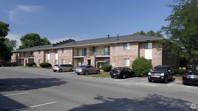
Property Record
5200 Hornet Ave, Beech Grove, IN 46107

NEARBY LISTINGS FOR SALE OR LEASE
Property Detail
5200 Hornet Ave
49-10-27-124-003.000-302
Churchman Place Add
Apartment
37AC
AE
Marion
18097C0254F
Indiana
2023
15.04 AC
2024
Beech Grove
380404
Indianapolis
10,400 SF
Indianapolis-Carmel-Anderson, IN
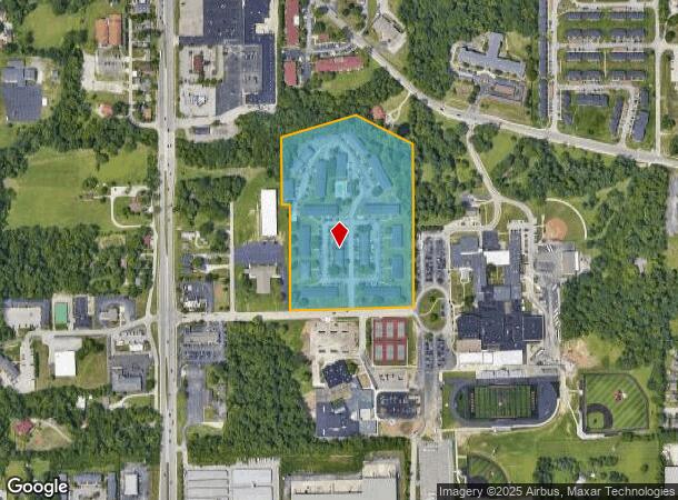
DEMOGRAPHICS near 5200 Hornet Ave
1 Mile
3 Mile
5 Mile
2024 Total Population
6,955
70,261
218,445
2029 Population
6,784
69,110
216,883
Pop Growth 2024-2029
(2.46%)
(1.64%)
(0.72%)
Average Age
39
37
37
2024 Total Households
2,920
26,926
85,475
HH Growth 2024-2029
(2.57%)
(1.72%)
(0.75%)
Median Household Inc
$55,059
$60,549
$60,147
Avg Household Size
2.40
2.50
2.50
2024 Avg HH Vehicles
2.00
2.00
2.00
Median Home Value
$152,401
$167,461
$180,802
Median Year Built
1966
1972
1966
Nearby Places
Map Layers
Map Styles
 Street
 Aerial
- Restaurants
- Banks
- Shops
- Fitness
- Groceries
PUBLIC TRANSPORTATION
COMMUTER RAIL
Indianapolis (Cardinal - Amtrak)
DRIVE
WALK
Distance
Indianapolis (Cardinal - Amtrak)
12 min
7.6 mi
AIRPORT
Indianapolis International
DRIVE
WALK
Distance
Indianapolis International
31 min
18.5 mi
Freight Ports
Port of Toledo
DRIVE
WALK
Distance
Port of Toledo
273 min
229.4 mi
SALE & LEASE HISTORY
LISTING DATE
SALE/LEASE

Sep 26, 2018
For Sale
Nearby Properties
Address
Land Use
TOTAL SIZE
Lot Size
Zoning
Address
Land Use
TOTAL SIZE
Lot Size
Zoning
19,927 SF
28.82 AC
ZO01
Address
Land Use
TOTAL SIZE
Lot Size
Zoning
9,888 SF
124.20 AC
ZO01
Address
Land Use
TOTAL SIZE
Lot Size
Zoning
1,362 SF
6.66 AC
ZO01
Address
Land Use
TOTAL SIZE
Lot Size
Zoning
80,348 SF
2.95 AC
ZO01
Address
Land Use
TOTAL SIZE
Lot Size
Zoning
405,664 SF
35.56 AC
ZO01
Address
Land Use
TOTAL SIZE
Lot Size
Zoning
51,196 SF
50.61 AC
ZO01
Address
Land Use
TOTAL SIZE
Lot Size
Zoning
352,000 SF
22.72 AC
ZO01
Address
Land Use
TOTAL SIZE
Lot Size
Zoning
3,003 SF
3.52 AC
ZO01
Address
Land Use
TOTAL SIZE
Lot Size
Zoning
37,718 SF
11.77 AC
ZO01
Address
Land Use
TOTAL SIZE
Lot Size
Zoning
1,660 SF
15.01 AC
ZO01
Address
Land Use
TOTAL SIZE
Lot Size
Zoning
405 SF
23.81 AC
ZO01
Address
Land Use
TOTAL SIZE
Lot Size
Zoning
2,486 SF
13.75 AC
ZO01
Address
Land Use
TOTAL SIZE
Lot Size
Zoning
4,179 SF
28.11 AC
ZO01
Address
Land Use
TOTAL SIZE
Lot Size
Zoning
4,212 SF
16 AC
Address
Land Use
TOTAL SIZE
Lot Size
Zoning
208,224 SF
23.41 AC
ZO01
Address
Land Use
TOTAL SIZE
Lot Size
Zoning
4,872 SF
12.37 AC
Address
Land Use
TOTAL SIZE
Lot Size
Zoning
1,575 SF
10.24 AC
Address
Land Use
TOTAL SIZE
Lot Size
Zoning
1,040 SF
15.62 AC
ZO01
Address
Land Use
TOTAL SIZE
Lot Size
Zoning
101,122 SF
16.44 AC
Address
Land Use
TOTAL SIZE
Lot Size
Zoning
61,750 SF
18.59 AC
Address
Land Use
TOTAL SIZE
Lot Size
Zoning
209,756 SF
12.33 AC
ZO01
Address
Land Use
TOTAL SIZE
Lot Size
Zoning
87,807 SF
9.04 AC
ZO01
Address
Land Use
TOTAL SIZE
Lot Size
Zoning
121,055 SF
12.71 AC
ZO01
Address
Land Use
TOTAL SIZE
Lot Size
Zoning
20,944 SF
8.27 AC
ZO01
Address
Land Use
TOTAL SIZE
Lot Size
Zoning
13,876 SF
28.93 AC
ZO01
Address
Land Use
TOTAL SIZE
Lot Size
Zoning
27,703 SF
22 AC
Address
Land Use
TOTAL SIZE
Lot Size
Zoning
101,734 SF
14.31 AC
ZO01
Address
Land Use
TOTAL SIZE
Lot Size
Zoning
45,303 SF
15.51 AC
ZO01
Address
Land Use
TOTAL SIZE
Lot Size
Zoning
37,476 SF
8.96 AC
ZO01
The World's #1 Commercial Real Estate Marketplace
Connect with us
© 2026 CoStar Group
The information above has been obtained from sources believed reliable. While we do not doubt its accuracy we have not verified it and make no guarantee, warranty or representation about it. It is your responsibility to independently confirm its accuracy and completeness. Any projections, opinions, assumptions, or estimates used are for example only and do not represent the current or future performance of the property. The value of this transaction to you depends on tax and other factors which should be evaluated by your tax, financial, and legal advisors. You and your advisors should conduct a careful, independent investigation of the property to determine to your satisfaction the suitability of the property for your needs.