Property Record
5200 Sigstrom Dr, Carson City, NV 89706


Save to a Folder
{{folder.Name}}
{{folder.ListingIds.length}} Properties
{{folder.ListingIds.length}} Property
Create a New Folder
Property Detail
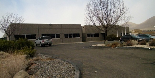
5200 Sigstrom Dr
008-816-36
PARCEL 1 MAP #792
Lightindustrial
Carson City
LI
Nevada
C and X Area of minimal flood hazard, usually depicted on FIRMs as above the 500-year flood level.
11
2025
1.83 AC
2025
Carson City County
000400
Reno/Sparks
23,480 SF
Carson City, NV
NEARBY LISTINGS FOR SALE OR LEASE
DEMOGRAPHICS near 5200 Sigstrom Dr
1 mile
3 mile
5 mile
2025 Total Population
496
30,504
53,572
2030 Population
481
30,373
53,415
Pop Growth 2025-2030
(3.02%)
(0.43%)
(0.29%)
Average Age
48
41
43
2025 Total Households
207
12,547
21,965
HH Growth 2025-2030
(2.90%)
(0.62%)
(0.35%)
Median Household Inc
$102,750
$65,087
$69,725
Avg Household Size
2.40
2.40
2.30
2025 Avg HH Vehicles
3.00
2.00
2.00
Median Home Value
$642,105
$398,646
$437,417
Median Year Built
1985
1980
1981
Nearby Places
Map Layers
Map Styles
 Street
 Aerial
Layers
 Traffic
 Biking
Places
Listings with unknown addresses are not visible on the map
- Restaurants
- Banks
- Shops
- Fitness
- Groceries
PUBLIC TRANSPORTATION
AIRPORT
Reno/Tahoe International
Drive
Walk
Distance
Reno/Tahoe International
55 min
32.1 mi
Freight Ports
Port of Stockton
Drive
Walk
Distance
Port of Stockton
227 min
156.3 mi
Nearby Properties
Address
Land Use
TOTAL SIZE
Lot Size
Zoning
Address
Land Use
TOTAL SIZE
Lot Size
Zoning
383,670 SF
31.92 AC
RC
Address
Land Use
TOTAL SIZE
Lot Size
Zoning
356,776 SF
64.42 AC
P
Address
Land Use
TOTAL SIZE
Lot Size
Zoning
7,419 SF
0.71 AC
PR
Address
Land Use
TOTAL SIZE
Lot Size
Zoning
96,057 SF
10 AC
LI
Address
Land Use
TOTAL SIZE
Lot Size
Zoning
213,246 SF
19.48 AC
GC-RC
Address
Land Use
TOTAL SIZE
Lot Size
Zoning
240 AC
PR
Address
Land Use
TOTAL SIZE
Lot Size
Zoning
137,022 SF
5.29 AC
RC
Address
Land Use
TOTAL SIZE
Lot Size
Zoning
109,200 SF
9.35 AC
GC
Address
Land Use
TOTAL SIZE
Lot Size
Zoning
169,086 SF
18.49 AC
RC-P
Address
Land Use
TOTAL SIZE
Lot Size
Zoning
29.98 AC
PC
Address
Land Use
TOTAL SIZE
Lot Size
Zoning
75,863 SF
3.92 AC
RC
Address
Land Use
TOTAL SIZE
Lot Size
Zoning
111,950 SF
18.20 AC
RC-MHP
Address
Land Use
TOTAL SIZE
Lot Size
Zoning
113,007 SF
52.90 AC
PR
Address
Land Use
TOTAL SIZE
Lot Size
Zoning
156,408 SF
2.08 AC
MFA-GC
Address
Land Use
TOTAL SIZE
Lot Size
Zoning
160,769 SF
15 AC
LI
Address
Land Use
TOTAL SIZE
Lot Size
Zoning
86,783 SF
52 AC
PR
Address
Land Use
TOTAL SIZE
Lot Size
Zoning
21.67 AC
RC-P
Address
Land Use
TOTAL SIZE
Lot Size
Zoning
20,800 SF
2.90 AC
GC
Address
Land Use
TOTAL SIZE
Lot Size
Zoning
68,342 SF
2.47 AC
TC
Address
Land Use
TOTAL SIZE
Lot Size
Zoning
256.42 AC
Address
Land Use
TOTAL SIZE
Lot Size
Zoning
45,406 SF
5.93 AC
Address
Land Use
TOTAL SIZE
Lot Size
Zoning
33,059 SF
4.90 AC
RC
Address
Land Use
TOTAL SIZE
Lot Size
Zoning
107,063 SF
10.96 AC
GC
Address
Land Use
TOTAL SIZE
Lot Size
Zoning
70,763 SF
9.54 AC
P
Address
Land Use
TOTAL SIZE
Lot Size
Zoning
85,751 SF
3.41 AC
Address
Land Use
TOTAL SIZE
Lot Size
Zoning
40,804 SF
3.87 AC
RC
Address
Land Use
TOTAL SIZE
Lot Size
Zoning
71,719 SF
1.89 AC
MFA
Address
Land Use
TOTAL SIZE
Lot Size
Zoning
34,438 SF
37.99 AC
CR-RC
Address
Land Use
TOTAL SIZE
Lot Size
Zoning
30,481 SF
4.94 AC
Address
Land Use
TOTAL SIZE
Lot Size
Zoning
53,183 SF
4.59 AC
NB-SF12-P
The World's #1 Commercial Real Estate Marketplace
Connect with us
© 2026 CoStar Group
The information above has been obtained from sources believed reliable. While we do not doubt its accuracy we have not verified it and make no guarantee, warranty or representation about it. It is your responsibility to independently confirm its accuracy and completeness. Any projections, opinions, assumptions, or estimates used are for example only and do not represent the current or future performance of the property. The value of this transaction to you depends on tax and other factors which should be evaluated by your tax, financial, and legal advisors. You and your advisors should conduct a careful, independent investigation of the property to determine to your satisfaction the suitability of the property for your needs.