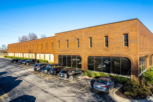
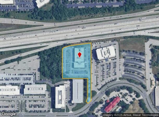
Property Record
5200 W 110Th St, Leawood, KS 66211

NEARBY LISTINGS FOR SALE OR LEASE
Property Detail
5200 W 110Th St
NF251309-2039
9-13-25 BG 850.23' N & 1422.35' W SE CR SW1/4 SW ALG NW RTWY/L 110 ST 50' NW 35' NE 51.12' N 222.49' W 295' N 368.59' TO S/L I-435 RWY NE 337.83' S 670.99' TO POB EX .014 AC 3.26 ACS M/L OPC 358 17
Officebuilding
Johnson
X
Kansas
20091C0069G
110
2024
3.26 AC
2024
College Blvd
053201
Kansas City
25,610 SF
Kansas City, MO-KS
DEMOGRAPHICS near 5200 W 110Th St
1 Mile
3 Mile
5 Mile
2024 Total Population
8,702
81,370
235,827
2029 Population
9,368
84,693
243,745
Pop Growth 2024-2029
+ 7.65%
+ 4.08%
+ 3.36%
Average Age
44
44
42
2024 Total Households
4,213
36,207
103,737
HH Growth 2024-2029
+ 7.88%
+ 4.29%
+ 3.44%
Median Household Inc
$102,433
$90,471
$87,174
Avg Household Size
1.90
2.20
2.20
2024 Avg HH Vehicles
2.00
2.00
2.00
Median Home Value
$429,656
$381,520
$334,802
Median Year Built
1998
1980
1979
Nearby Places
Map Layers
Map Styles
 Street
 Aerial
- Restaurants
- Banks
- Shops
- Fitness
- Groceries
PUBLIC TRANSPORTATION
AIRPORT
Kansas City International
DRIVE
WALK
Distance
Kansas City International
48 min
36.1 mi
SALE & LEASE HISTORY
LISTING DATE
SALE/LEASE

Sep 24, 2016
For Sale
Oct 04, 2023
For Sale
Mar 27, 2017
For Sale
Mar 27, 2017
For Sale
Mar 21, 2017
For Lease
Mar 21, 2017
For Sale
Dec 15, 2016
For Lease
Apr 17, 2025
For Sale
Apr 16, 2024
For Lease
Apr 16, 2024
For Sale
Nearby Properties
Address
Land Use
TOTAL SIZE
Lot Size
Zoning
Address
Land Use
TOTAL SIZE
Lot Size
Zoning
364,818 SF
25.48 AC
R-1
Address
Land Use
TOTAL SIZE
Lot Size
Zoning
47.39 AC
AG
Address
Land Use
TOTAL SIZE
Lot Size
Zoning
177,588 SF
9.27 AC
CP-O
Address
Land Use
TOTAL SIZE
Lot Size
Zoning
189,882 SF
13.04 AC
CP-O
Address
Land Use
TOTAL SIZE
Lot Size
Zoning
316,432 SF
29.39 AC
R-1
Address
Land Use
TOTAL SIZE
Lot Size
Zoning
3,426,762 SF
183.73 AC
CP-O
Address
Land Use
TOTAL SIZE
Lot Size
Zoning
122,309 SF
76.14 AC
R-1
Address
Land Use
TOTAL SIZE
Lot Size
Zoning
305,147 SF
49.02 AC
R-1
Address
Land Use
TOTAL SIZE
Lot Size
Zoning
335,643 SF
25.13 AC
R-1
Address
Land Use
TOTAL SIZE
Lot Size
Zoning
325,588 SF
36.63 AC
SD-CR
Address
Land Use
TOTAL SIZE
Lot Size
Zoning
79,917 SF
7.86 AC
SD-NCR
Address
Land Use
TOTAL SIZE
Lot Size
Zoning
120,305 SF
7.01 AC
CP-O
Address
Land Use
TOTAL SIZE
Lot Size
Zoning
259,257 SF
24.74 AC
CP-O
Address
Land Use
TOTAL SIZE
Lot Size
Zoning
96,100 SF
25.01 AC
R-1
Address
Land Use
TOTAL SIZE
Lot Size
Zoning
81,051 SF
7.17 AC
R-1
Address
Land Use
TOTAL SIZE
Lot Size
Zoning
110,710 SF
4.66 AC
CP-O
Address
Land Use
TOTAL SIZE
Lot Size
Zoning
59,570 SF
8.46 AC
SD-O
Address
Land Use
TOTAL SIZE
Lot Size
Zoning
113,263 SF
3.53 AC
CP-O
Address
Land Use
TOTAL SIZE
Lot Size
Zoning
73,383 SF
9.53 AC
R-1
Address
Land Use
TOTAL SIZE
Lot Size
Zoning
166,097 SF
37.29 AC
R-1
Address
Land Use
TOTAL SIZE
Lot Size
Zoning
105,110 SF
8.93 AC
AG
Address
Land Use
TOTAL SIZE
Lot Size
Zoning
73,793 SF
9.21 AC
R-1A
Address
Land Use
TOTAL SIZE
Lot Size
Zoning
69,958 SF
10.93 AC
R-1
Address
Land Use
TOTAL SIZE
Lot Size
Zoning
436,499 SF
22.71 AC
Address
Land Use
TOTAL SIZE
Lot Size
Zoning
355,197 SF
30.05 AC
CP-2
Address
Land Use
TOTAL SIZE
Lot Size
Zoning
179,965 SF
6.15 AC
CP-O
Address
Land Use
TOTAL SIZE
Lot Size
Zoning
863,831 SF
31.21 AC
BP
Address
Land Use
TOTAL SIZE
Lot Size
Zoning
120,225 SF
9.13 AC
R-1
Address
Land Use
TOTAL SIZE
Lot Size
Zoning
119,320 SF
19.74 AC
R-1
Address
Land Use
TOTAL SIZE
Lot Size
Zoning
66,083 SF
14.91 AC
R-1
The World's #1 Commercial Real Estate Marketplace
Connect with us
© 2025 CoStar Group
The information above has been obtained from sources believed reliable. While we do not doubt its accuracy we have not verified it and make no guarantee, warranty or representation about it. It is your responsibility to independently confirm its accuracy and completeness. Any projections, opinions, assumptions, or estimates used are for example only and do not represent the current or future performance of the property. The value of this transaction to you depends on tax and other factors which should be evaluated by your tax, financial, and legal advisors. You and your advisors should conduct a careful, independent investigation of the property to determine to your satisfaction the suitability of the property for your needs.