Property Record
5201 International Dr, Durham, NC 27712


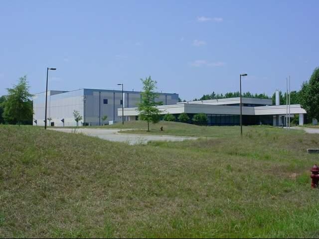
Property Detail
5201 International Dr
193010
PROP-JMC/TR#A SOUTHERN RESEARCH INSTITU PL:000135-000088
Scientificpharmaceuticalmedicalresearchfacility
Durham
IL
North Carolina
AE The base floodplain where base flood elevations are provided. AE Zones are now used on new format FIRMs instead of A1-A30 Zones.
28.04 AC
2025
North Durham
2025
Raleigh/Durham
002100
Durham-Chapel Hill, NC
41,121 SF
NEARBY LISTINGS FOR SALE OR LEASE
-
-
View all Durham listings for sale on LoopNet.com
DEMOGRAPHICS near 5201 International Dr
1 mile
3 mile
5 mile
2025 Total Population
90
7,374
43,055
2030 Population
94
7,694
45,044
Pop Growth 2025-2030
+ 4.44%
+ 4.34%
+ 4.62%
Average Age
47
44
41
2025 Total Households
16
2,642
14,752
HH Growth 2025-2030
+ 6.25%
+ 4.50%
+ 4.89%
Median Household Inc
$87,500
$95,511
$72,593
Avg Household Size
2.30
2.60
2.60
2025 Avg HH Vehicles
3.00
2.00
2.00
Median Home Value
$450,000
$409,037
$351,908
Median Year Built
1979
1992
1988
Nearby Places
Map Layers
Map Styles
 Street
 Aerial
Layers
 Traffic
 Biking
Places
Listings with unknown addresses are not visible on the map
- Restaurants
- Banks
- Shops
- Fitness
- Groceries
PUBLIC TRANSPORTATION
COMMUTER RAIL
Drive
Walk
Distance
23 min
9.1 mi
AIRPORT
Raleigh-Durham International
Drive
Walk
Distance
Raleigh-Durham International
37 min
22.0 mi
SALE & LEASE HISTORY
LISTING DATE
SALE/LEASE

May 18, 2018
For Sale
Nearby Properties
Address
Land Use
TOTAL SIZE
Lot Size
Zoning
Address
Land Use
TOTAL SIZE
Lot Size
Zoning
906,736 SF
258.08 AC
IL
Address
Land Use
TOTAL SIZE
Lot Size
Zoning
527,109 SF
114.99 AC
IL
Address
Land Use
TOTAL SIZE
Lot Size
Zoning
851,552 SF
123.42 AC
IL
Address
Land Use
TOTAL SIZE
Lot Size
Zoning
385,175 SF
130.35 AC
SRP
Address
Land Use
TOTAL SIZE
Lot Size
Zoning
139,872 SF
49.06 AC
IL
Address
Land Use
TOTAL SIZE
Lot Size
Zoning
1,661.50 AC
RR
Address
Land Use
TOTAL SIZE
Lot Size
Zoning
156,483 SF
31.52 AC
RR
Address
Land Use
TOTAL SIZE
Lot Size
Zoning
187,680 SF
38.82 AC
Address
Land Use
TOTAL SIZE
Lot Size
Zoning
209,900 SF
30.20 AC
RR
Address
Land Use
TOTAL SIZE
Lot Size
Zoning
85,651 SF
23.23 AC
PDR 2.240
Address
Land Use
TOTAL SIZE
Lot Size
Zoning
89,440 SF
15 AC
IL
Address
Land Use
TOTAL SIZE
Lot Size
Zoning
53,944 SF
59.79 AC
RR
Address
Land Use
TOTAL SIZE
Lot Size
Zoning
120.14 AC
IL
Address
Land Use
TOTAL SIZE
Lot Size
Zoning
475.76 AC
RR
Address
Land Use
TOTAL SIZE
Lot Size
Zoning
225,877 SF
87.41 AC
Address
Land Use
TOTAL SIZE
Lot Size
Zoning
405.60 AC
RR
Address
Land Use
TOTAL SIZE
Lot Size
Zoning
70.44 AC
RS-20
Address
Land Use
TOTAL SIZE
Lot Size
Zoning
50,864 SF
10.04 AC
PDR 2.240
Address
Land Use
TOTAL SIZE
Lot Size
Zoning
57.10 AC
IL (D)
Address
Land Use
TOTAL SIZE
Lot Size
Zoning
11,740 SF
249.03 AC
RR,RS-20
Address
Land Use
TOTAL SIZE
Lot Size
Zoning
11,881 SF
14.25 AC
IL
Address
Land Use
TOTAL SIZE
Lot Size
Zoning
38,702 SF
210.53 AC
PDR 2.240
Address
Land Use
TOTAL SIZE
Lot Size
Zoning
50.18 AC
IL
Address
Land Use
TOTAL SIZE
Lot Size
Zoning
109.05 AC
IL
Address
Land Use
TOTAL SIZE
Lot Size
Zoning
70,080 SF
19.50 AC
IL
Address
Land Use
TOTAL SIZE
Lot Size
Zoning
27,000 SF
10.02 AC
IL
Address
Land Use
TOTAL SIZE
Lot Size
Zoning
249.49 AC
RR
Address
Land Use
TOTAL SIZE
Lot Size
Zoning
244.77 AC
RR
Address
Land Use
TOTAL SIZE
Lot Size
Zoning
227.05 AC
RR
The World's #1 Commercial Real Estate Marketplace
Connect with us
© 2026 CoStar Group
The information above has been obtained from sources believed reliable. While we do not doubt its accuracy we have not verified it and make no guarantee, warranty or representation about it. It is your responsibility to independently confirm its accuracy and completeness. Any projections, opinions, assumptions, or estimates used are for example only and do not represent the current or future performance of the property. The value of this transaction to you depends on tax and other factors which should be evaluated by your tax, financial, and legal advisors. You and your advisors should conduct a careful, independent investigation of the property to determine to your satisfaction the suitability of the property for your needs.