Property Record
5201 Martin Luther King Blvd, Houston, TX 77021
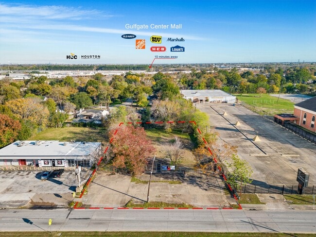
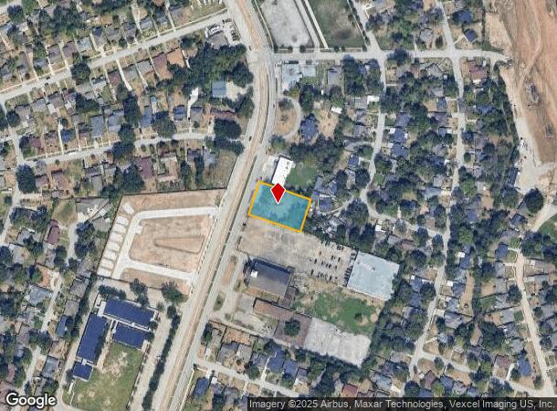
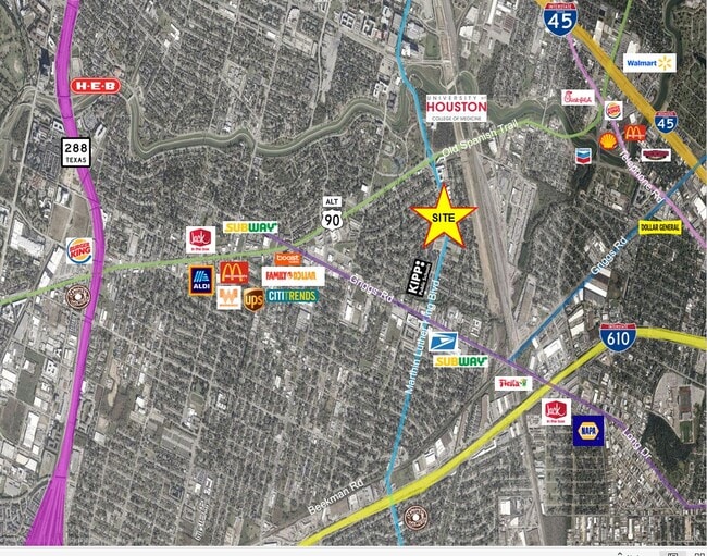
This Property Is For Sale
NEARBY LISTINGS FOR SALE OR LEASE
Property Detail
5201 Martin Luther King Blvd
Houston-The Woodlands-Sugar Land, TX
Abst 51 L Moore
0410070310076
TR 10A ABST 51 L MOORE
Commercialacreage
Harris
X
Texas
48201C0880M
0.55 AC
2024
South
2025
Houston
313300
DEMOGRAPHICS near 5201 Martin Luther King Blvd
1 Mile
3 Mile
5 Mile
2024 Total Population
10,488
161,408
401,583
2029 Population
10,691
166,711
415,548
Pop Growth 2024-2029
+ 1.94%
+ 3.29%
+ 3.48%
Average Age
38
36
37
2024 Total Households
3,852
57,441
159,194
HH Growth 2024-2029
+ 1.87%
+ 3.57%
+ 3.80%
Median Household Inc
$40,115
$40,123
$52,081
Avg Household Size
2.50
2.50
2.30
2024 Avg HH Vehicles
2.00
2.00
1.00
Median Home Value
$162,214
$177,207
$213,693
Median Year Built
1960
1961
1975
Nearby Places
Map Layers
Map Styles
 Street
 Aerial
- Restaurants
- Banks
- Shops
- Fitness
- Groceries
PUBLIC TRANSPORTATION
TRANSIT/SUBWAY
Macgregor Park Mlk Sb (METRORAIL PURPLE LINE - Metropolitan Transit Authority of Harris County)
DRIVE
WALK
Distance
Macgregor Park Mlk Sb (METRORAIL PURPLE LINE - Metropolitan Transit Authority of Harris County)
2 min
10 min
0.5 mi
Palm Center Transit Ctr Sb (METRORAIL PURPLE LINE - Metropolitan Transit Authority of Harris County)
DRIVE
WALK
Distance
Palm Center Transit Ctr Sb (METRORAIL PURPLE LINE - Metropolitan Transit Authority of Harris County)
3 min
13 min
0.7 mi
COMMUTER RAIL
Houston (Sunset Limited - Amtrak)
DRIVE
WALK
Distance
Houston (Sunset Limited - Amtrak)
10 min
6.2 mi
AIRPORT
William P Hobby
DRIVE
WALK
Distance
William P Hobby
19 min
8.6 mi
George Bush Intcntl/Houston
DRIVE
WALK
Distance
George Bush Intcntl/Houston
33 min
23.3 mi
Freight Ports
Port of Houston
DRIVE
WALK
Distance
Port of Houston
16 min
8.6 mi
Nearby Properties
Address
Land Use
TOTAL SIZE
Lot Size
Zoning
Address
Land Use
TOTAL SIZE
Lot Size
Zoning
486,076 SF
3.79 AC
Address
Land Use
TOTAL SIZE
Lot Size
Zoning
453,987 SF
4.33 AC
Address
Land Use
TOTAL SIZE
Lot Size
Zoning
403,242 SF
46.18 AC
Address
Land Use
TOTAL SIZE
Lot Size
Zoning
557,397 SF
5.58 AC
Address
Land Use
TOTAL SIZE
Lot Size
Zoning
1,171,276 SF
44.19 AC
Address
Land Use
TOTAL SIZE
Lot Size
Zoning
372,028 SF
26.56 AC
Address
Land Use
TOTAL SIZE
Lot Size
Zoning
643,698 SF
6.57 AC
Address
Land Use
TOTAL SIZE
Lot Size
Zoning
257,963 SF
6.39 AC
Address
Land Use
TOTAL SIZE
Lot Size
Zoning
474,970 SF
6.95 AC
Address
Land Use
TOTAL SIZE
Lot Size
Zoning
278,362 SF
1.70 AC
Address
Land Use
TOTAL SIZE
Lot Size
Zoning
159,235 SF
1.49 AC
Address
Land Use
TOTAL SIZE
Lot Size
Zoning
242,936 SF
Address
Land Use
TOTAL SIZE
Lot Size
Zoning
310,171 SF
2.35 AC
Address
Land Use
TOTAL SIZE
Lot Size
Zoning
17.84 AC
Address
Land Use
TOTAL SIZE
Lot Size
Zoning
757,830 SF
31.03 AC
Address
Land Use
TOTAL SIZE
Lot Size
Zoning
245,307 SF
1.67 AC
Address
Land Use
TOTAL SIZE
Lot Size
Zoning
358,709 SF
2.66 AC
Address
Land Use
TOTAL SIZE
Lot Size
Zoning
389,108 SF
37.39 AC
Address
Land Use
TOTAL SIZE
Lot Size
Zoning
198,023 SF
17.87 AC
Address
Land Use
TOTAL SIZE
Lot Size
Zoning
279,334 SF
2 AC
Address
Land Use
TOTAL SIZE
Lot Size
Zoning
92,539 SF
12.12 AC
Address
Land Use
TOTAL SIZE
Lot Size
Zoning
901,984 SF
59.37 AC
Address
Land Use
TOTAL SIZE
Lot Size
Zoning
504,018 SF
37.16 AC
Address
Land Use
TOTAL SIZE
Lot Size
Zoning
419,760 SF
15.27 AC
Address
Land Use
TOTAL SIZE
Lot Size
Zoning
785,097 SF
27.77 AC
Address
Land Use
TOTAL SIZE
Lot Size
Zoning
923,370 SF
13.76 AC
Address
Land Use
TOTAL SIZE
Lot Size
Zoning
232,915 SF
7.89 AC
Address
Land Use
TOTAL SIZE
Lot Size
Zoning
228,886 SF
1.85 AC
Address
Land Use
TOTAL SIZE
Lot Size
Zoning
267,844 SF
10.98 AC
Address
Land Use
TOTAL SIZE
Lot Size
Zoning
194,296 SF
15.13 AC
The World's #1 Commercial Real Estate Marketplace
Connect with us
© 2025 CoStar Group
The information above has been obtained from sources believed reliable. While we do not doubt its accuracy we have not verified it and make no guarantee, warranty or representation about it. It is your responsibility to independently confirm its accuracy and completeness. Any projections, opinions, assumptions, or estimates used are for example only and do not represent the current or future performance of the property. The value of this transaction to you depends on tax and other factors which should be evaluated by your tax, financial, and legal advisors. You and your advisors should conduct a careful, independent investigation of the property to determine to your satisfaction the suitability of the property for your needs.