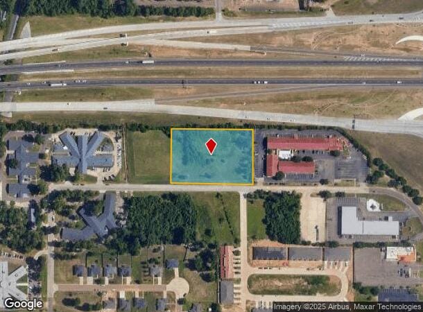
Property Record
W 52Nd St, Texarkana, TX 75503
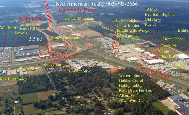
NEARBY LISTINGS FOR SALE OR LEASE
Property Detail
W 52Nd St
Texarkana, TX-AR
Willis Oldham A-458
17500003700
WILLIS OLDHAM A-458 5531/168 12/29/08 BLK/TRACT 137 2.24 ACRES
Vacantlandnec
Bowie
X
Texas
48037C0360E
2.24 AC
2024
Texas East Area
2025
Other Market Areas
010903
DEMOGRAPHICS near W 52Nd St
1 Mile
3 Mile
5 Mile
2024 Total Population
4,830
40,617
68,137
2029 Population
4,782
40,616
68,356
Pop Growth 2024-2029
(0.99%)
0.00%
+ 0.32%
Average Age
41
40
39
2024 Total Households
2,007
16,645
27,296
HH Growth 2024-2029
(1.00%)
+ 0.02%
+ 0.32%
Median Household Inc
$51,527
$46,778
$43,985
Avg Household Size
2.20
2.30
2.30
2024 Avg HH Vehicles
2.00
2.00
2.00
Median Home Value
$164,161
$148,870
$146,378
Median Year Built
1987
1978
1979
Nearby Places
Map Layers
Map Styles
 Street
 Aerial
- Restaurants
- Banks
- Shops
- Fitness
- Groceries
PUBLIC TRANSPORTATION
COMMUTER RAIL
DRIVE
WALK
Distance
8 min
3.7 mi
AIRPORT
Texarkana Regional-Webb Field
DRIVE
WALK
Distance
Texarkana Regional-Webb Field
14 min
6.1 mi
Nearby Properties
Address
Land Use
TOTAL SIZE
Lot Size
Zoning
Address
Land Use
TOTAL SIZE
Lot Size
Zoning
37.76 AC
Address
Land Use
TOTAL SIZE
Lot Size
Zoning
594,669 SF
26.19 AC
Address
Land Use
TOTAL SIZE
Lot Size
Zoning
22.35 AC
Address
Land Use
TOTAL SIZE
Lot Size
Zoning
Address
Land Use
TOTAL SIZE
Lot Size
Zoning
162,169 SF
19.18 AC
Address
Land Use
TOTAL SIZE
Lot Size
Zoning
133,136 SF
5.80 AC
Address
Land Use
TOTAL SIZE
Lot Size
Zoning
3,642 SF
24.74 AC
Address
Land Use
TOTAL SIZE
Lot Size
Zoning
11,320 SF
142 AC
Address
Land Use
TOTAL SIZE
Lot Size
Zoning
97,914 SF
3.01 AC
Address
Land Use
TOTAL SIZE
Lot Size
Zoning
73,675 SF
4.44 AC
Address
Land Use
TOTAL SIZE
Lot Size
Zoning
8.19 AC
Address
Land Use
TOTAL SIZE
Lot Size
Zoning
101,354 SF
33.83 AC
Address
Land Use
TOTAL SIZE
Lot Size
Zoning
533,299 SF
50.60 AC
Address
Land Use
TOTAL SIZE
Lot Size
Zoning
51,587 SF
6.44 AC
Address
Land Use
TOTAL SIZE
Lot Size
Zoning
87,452 SF
2.32 AC
Address
Land Use
TOTAL SIZE
Lot Size
Zoning
133,067 SF
11.20 AC
Address
Land Use
TOTAL SIZE
Lot Size
Zoning
18.64 AC
Address
Land Use
TOTAL SIZE
Lot Size
Zoning
12,449 SF
9.50 AC
Address
Land Use
TOTAL SIZE
Lot Size
Zoning
51,049 SF
1.78 AC
Address
Land Use
TOTAL SIZE
Lot Size
Zoning
165,001 SF
26.11 AC
Address
Land Use
TOTAL SIZE
Lot Size
Zoning
109,855 SF
6.24 AC
Address
Land Use
TOTAL SIZE
Lot Size
Zoning
18,105 SF
2.50 AC
Address
Land Use
TOTAL SIZE
Lot Size
Zoning
175,650 SF
15.56 AC
Address
Land Use
TOTAL SIZE
Lot Size
Zoning
116,386 SF
8.93 AC
Address
Land Use
TOTAL SIZE
Lot Size
Zoning
125,400 SF
9.47 AC
Address
Land Use
TOTAL SIZE
Lot Size
Zoning
25,006 SF
3.93 AC
Address
Land Use
TOTAL SIZE
Lot Size
Zoning
49,330 SF
2.26 AC
Address
Land Use
TOTAL SIZE
Lot Size
Zoning
160,484 SF
10.01 AC
Address
Land Use
TOTAL SIZE
Lot Size
Zoning
42,117 SF
0.86 AC
Address
Land Use
TOTAL SIZE
Lot Size
Zoning
89,848 SF
7.15 AC
The World's #1 Commercial Real Estate Marketplace
Connect with us
© 2025 CoStar Group
The information above has been obtained from sources believed reliable. While we do not doubt its accuracy we have not verified it and make no guarantee, warranty or representation about it. It is your responsibility to independently confirm its accuracy and completeness. Any projections, opinions, assumptions, or estimates used are for example only and do not represent the current or future performance of the property. The value of this transaction to you depends on tax and other factors which should be evaluated by your tax, financial, and legal advisors. You and your advisors should conduct a careful, independent investigation of the property to determine to your satisfaction the suitability of the property for your needs.