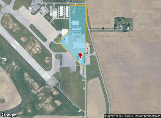
Property Record
5201 N Walnut St, Muncie, IN 47303

NEARBY LISTINGS FOR SALE OR LEASE
Property Detail
5201 N Walnut St
18-07-28-400-003.000-006
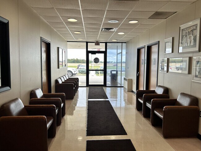
Airport Restaurant Addition
Restaurantbuilding
PT SE QTR 9.3100ACRES STR: 282110 IN: OUT:
X
Delaware
18035C0232D
Indiana
2024
9.31 AC
2024
Muncie/Delaware County
002604
Indianapolis
8,734 SF
Muncie, IN
DEMOGRAPHICS near 5201 N Walnut St
1 Mile
3 Mile
5 Mile
2024 Total Population
1,152
38,612
77,826
2029 Population
1,170
39,319
79,805
Pop Growth 2024-2029
+ 1.56%
+ 1.83%
+ 2.54%
Average Age
43
35
38
2024 Total Households
538
14,565
31,609
HH Growth 2024-2029
+ 1.49%
+ 2.15%
+ 2.71%
Median Household Inc
$62,935
$45,691
$45,023
Avg Household Size
2.00
2.10
2.20
2024 Avg HH Vehicles
2.00
2.00
2.00
Median Home Value
$86,330
$121,102
$101,029
Median Year Built
1986
1971
1964
Nearby Places
Map Layers
Map Styles
 Street
 Aerial
- Restaurants
- Banks
- Shops
- Fitness
- Groceries
SALE & LEASE HISTORY
LISTING DATE
SALE/LEASE

Apr 10, 2025
For Sale
Nearby Properties
Address
Land Use
TOTAL SIZE
Lot Size
Zoning
Address
Land Use
TOTAL SIZE
Lot Size
Zoning
212,625 SF
34.32 AC
Address
Land Use
TOTAL SIZE
Lot Size
Zoning
112,553 SF
17.17 AC
Address
Land Use
TOTAL SIZE
Lot Size
Zoning
127,495 SF
25 AC
Address
Land Use
TOTAL SIZE
Lot Size
Zoning
82,160 SF
14.32 AC
Address
Land Use
TOTAL SIZE
Lot Size
Zoning
24,036 SF
7.21 AC
Address
Land Use
TOTAL SIZE
Lot Size
Zoning
2,125 SF
51.91 AC
Address
Land Use
TOTAL SIZE
Lot Size
Zoning
77,145 SF
10.45 AC
Address
Land Use
TOTAL SIZE
Lot Size
Zoning
9,280 SF
19.77 AC
Address
Land Use
TOTAL SIZE
Lot Size
Zoning
17,240 SF
10.56 AC
Address
Land Use
TOTAL SIZE
Lot Size
Zoning
231,752 SF
6.64 AC
Address
Land Use
TOTAL SIZE
Lot Size
Zoning
367,525 SF
1.36 AC
Address
Land Use
TOTAL SIZE
Lot Size
Zoning
170,740 SF
2.30 AC
Address
Land Use
TOTAL SIZE
Lot Size
Zoning
92,340 SF
9.22 AC
Address
Land Use
TOTAL SIZE
Lot Size
Zoning
181,950 SF
0.45 AC
Address
Land Use
TOTAL SIZE
Lot Size
Zoning
14,594 SF
13.39 AC
Address
Land Use
TOTAL SIZE
Lot Size
Zoning
40,050 SF
9.05 AC
Address
Land Use
TOTAL SIZE
Lot Size
Zoning
5,177 SF
12 AC
Address
Land Use
TOTAL SIZE
Lot Size
Zoning
88,495 SF
8.93 AC
Address
Land Use
TOTAL SIZE
Lot Size
Zoning
142,628 SF
13.07 AC
Address
Land Use
TOTAL SIZE
Lot Size
Zoning
9,000 SF
43.70 AC
Address
Land Use
TOTAL SIZE
Lot Size
Zoning
108,480 SF
2.61 AC
Address
Land Use
TOTAL SIZE
Lot Size
Zoning
92,044 SF
21.84 AC
Address
Land Use
TOTAL SIZE
Lot Size
Zoning
80,000 SF
49.86 AC
Address
Land Use
TOTAL SIZE
Lot Size
Zoning
57,399 SF
16.87 AC
Address
Land Use
TOTAL SIZE
Lot Size
Zoning
22,917 SF
7.32 AC
Address
Land Use
TOTAL SIZE
Lot Size
Zoning
43,139 SF
1.02 AC
Address
Land Use
TOTAL SIZE
Lot Size
Zoning
45,870 SF
2.75 AC
Address
Land Use
TOTAL SIZE
Lot Size
Zoning
59,900 SF
6.82 AC
Address
Land Use
TOTAL SIZE
Lot Size
Zoning
6,158 SF
11.84 AC
Address
Land Use
TOTAL SIZE
Lot Size
Zoning
93,444 SF
8.28 AC
The World's #1 Commercial Real Estate Marketplace
Connect with us
© 2026 CoStar Group
The information above has been obtained from sources believed reliable. While we do not doubt its accuracy we have not verified it and make no guarantee, warranty or representation about it. It is your responsibility to independently confirm its accuracy and completeness. Any projections, opinions, assumptions, or estimates used are for example only and do not represent the current or future performance of the property. The value of this transaction to you depends on tax and other factors which should be evaluated by your tax, financial, and legal advisors. You and your advisors should conduct a careful, independent investigation of the property to determine to your satisfaction the suitability of the property for your needs.