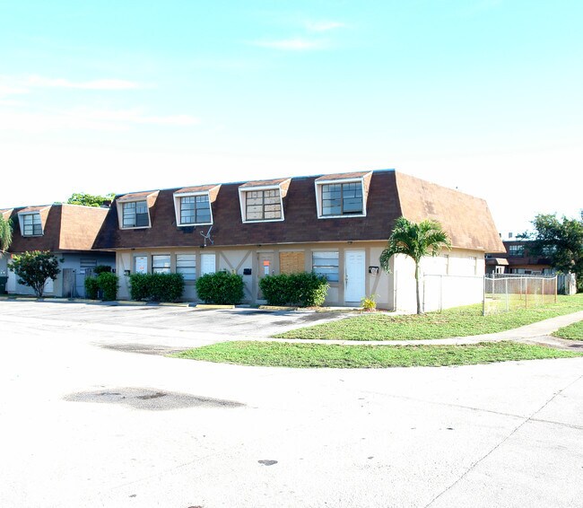
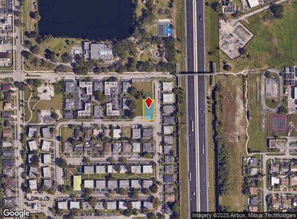
Property Record
5201 Nw 18Th St, Lauderhill, FL 33313

NEARBY LISTINGS FOR SALE OR LEASE
Property Detail
5201 Nw 18Th St
Fort Lauderdale-Pompano Beach-Deerfield Beach, FL
Sunshine Villas First Add
49-41-35-28-0552
SUNSHINE VILLAS FIRST ADD 71-45 B TR A LESS N 144.50 & LESS W 351.50
Parkinglot
Broward
X
Florida
12011C0363J
a
2024
0.26 AC
2025
Sunrise
060304
South Florida
3,594 SF
DEMOGRAPHICS near 5201 Nw 18Th St
1 Mile
3 Mile
5 Mile
2024 Total Population
43,040
207,805
485,681
2029 Population
43,277
209,638
485,312
Pop Growth 2024-2029
+ 0.55%
+ 0.88%
(0.08%)
Average Age
37
40
40
2024 Total Households
15,164
77,539
184,279
HH Growth 2024-2029
+ 0.47%
+ 0.86%
(0.32%)
Median Household Inc
$37,442
$46,303
$53,931
Avg Household Size
2.70
2.60
2.50
2024 Avg HH Vehicles
1.00
1.00
2.00
Median Home Value
$192,481
$228,782
$263,141
Median Year Built
1974
1975
1977
Nearby Places
Map Layers
Map Styles
 Street
 Aerial
- Restaurants
- Banks
- Shops
- Fitness
- Groceries
PUBLIC TRANSPORTATION
COMMUTER RAIL
Fort Lauderdale (Tri-County Commuter - South Florida Regional Transportation Authority (Tri-Rail))
DRIVE
WALK
Distance
Fort Lauderdale (Tri-County Commuter - South Florida Regional Transportation Authority (Tri-Rail))
15 min
5.9 mi
Fort Lauderdale (Mainline - Brightline)
DRIVE
WALK
Distance
Fort Lauderdale (Mainline - Brightline)
15 min
7.0 mi
AIRPORT
Fort Lauderdale/Hollywood International
DRIVE
WALK
Distance
Fort Lauderdale/Hollywood International
21 min
10.8 mi
Miami International
DRIVE
WALK
Distance
Miami International
50 min
35.5 mi
Freight Ports
Port Everglades
DRIVE
WALK
Distance
Port Everglades
20 min
10.0 mi
Nearby Properties
Address
Land Use
TOTAL SIZE
Lot Size
Zoning
Address
Land Use
TOTAL SIZE
Lot Size
Zoning
663,255 SF
3.15 AC
RAC-CC
Address
Land Use
TOTAL SIZE
Lot Size
Zoning
507,890 SF
39.49 AC
M-PM
Address
Land Use
TOTAL SIZE
Lot Size
Zoning
483,069 SF
23.09 AC
CF
Address
Land Use
TOTAL SIZE
Lot Size
Zoning
497,004 SF
4.46 AC
M-PM
Address
Land Use
TOTAL SIZE
Lot Size
Zoning
524,015 SF
6.43 AC
B-7Q
Address
Land Use
TOTAL SIZE
Lot Size
Zoning
346,662 SF
26.47 AC
RM-18
Address
Land Use
TOTAL SIZE
Lot Size
Zoning
464,170 SF
43.19 AC
CF
Address
Land Use
TOTAL SIZE
Lot Size
Zoning
597,732 SF
55.47 AC
CF
Address
Land Use
TOTAL SIZE
Lot Size
Zoning
256,568 SF
22.61 AC
PRD-12.15Q
Address
Land Use
TOTAL SIZE
Lot Size
Zoning
289,523 SF
9.44 AC
B-HCS
Address
Land Use
TOTAL SIZE
Lot Size
Zoning
321,240 SF
2.16 AC
M-PM
Address
Land Use
TOTAL SIZE
Lot Size
Zoning
296,166 SF
18.40 AC
RM-18
Address
Land Use
TOTAL SIZE
Lot Size
Zoning
277,664 SF
21.35 AC
PRD-12.15Q
Address
Land Use
TOTAL SIZE
Lot Size
Zoning
300,359 SF
11.76 AC
PRD-15.7Q
Address
Land Use
TOTAL SIZE
Lot Size
Zoning
309,879 SF
7.78 AC
TND-PUD
Address
Land Use
TOTAL SIZE
Lot Size
Zoning
262,844 SF
10.85 AC
B-FCC
Address
Land Use
TOTAL SIZE
Lot Size
Zoning
234,496 SF
3.07 AC
M-PM
Address
Land Use
TOTAL SIZE
Lot Size
Zoning
231,498 SF
19.56 AC
PRD-12.15Q
Address
Land Use
TOTAL SIZE
Lot Size
Zoning
157,841 SF
3.03 AC
I-L2P
Address
Land Use
TOTAL SIZE
Lot Size
Zoning
248,539 SF
0.13 AC
M-PM
Address
Land Use
TOTAL SIZE
Lot Size
Zoning
337,771 SF
20.62 AC
PRD-17Q
Address
Land Use
TOTAL SIZE
Lot Size
Zoning
291,638 SF
15.08 AC
PRD-15Q
Address
Land Use
TOTAL SIZE
Lot Size
Zoning
321,043 SF
34.99 AC
CF-P
Address
Land Use
TOTAL SIZE
Lot Size
Zoning
188,466 SF
0.73 AC
M-PM
Address
Land Use
TOTAL SIZE
Lot Size
Zoning
692,139 SF
24.33 AC
RM-45
Address
Land Use
TOTAL SIZE
Lot Size
Zoning
281,912 SF
12.69 AC
B-4
Address
Land Use
TOTAL SIZE
Lot Size
Zoning
327,367 SF
1.89 AC
M-PM
Address
Land Use
TOTAL SIZE
Lot Size
Zoning
400,154 SF
9.69 AC
RM-45
Address
Land Use
TOTAL SIZE
Lot Size
Zoning
495,360 SF
3.09 AC
RM-45
Address
Land Use
TOTAL SIZE
Lot Size
Zoning
291,880 SF
10.33 AC
CF
The World's #1 Commercial Real Estate Marketplace
Connect with us
© 2025 CoStar Group
The information above has been obtained from sources believed reliable. While we do not doubt its accuracy we have not verified it and make no guarantee, warranty or representation about it. It is your responsibility to independently confirm its accuracy and completeness. Any projections, opinions, assumptions, or estimates used are for example only and do not represent the current or future performance of the property. The value of this transaction to you depends on tax and other factors which should be evaluated by your tax, financial, and legal advisors. You and your advisors should conduct a careful, independent investigation of the property to determine to your satisfaction the suitability of the property for your needs.