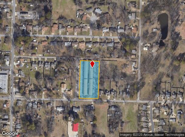
Property Record
5201 Spradling Ave, Fort Smith, AR 72904

NEARBY LISTINGS FOR SALE OR LEASE
Property Detail
5201 Spradling Ave
Fort Smith, AR-OK
Stoughs Electric Park #2
17536-0007-00002-00
LOTS 5-8 BLK 2
Apartment
Sebastian
X
Arkansas
05131C0040F
5-8
2025
1.80 AC
2025
Fort Smith Northside
000100
Fort Smith
42,284 SF
DEMOGRAPHICS near 5201 Spradling Ave
1 Mile
3 Mile
5 Mile
2024 Total Population
6,591
42,449
85,812
2029 Population
6,729
43,685
88,263
Pop Growth 2024-2029
+ 2.09%
+ 2.91%
+ 2.86%
Average Age
34
37
38
2024 Total Households
2,147
15,768
33,561
HH Growth 2024-2029
+ 2.00%
+ 2.95%
+ 2.86%
Median Household Inc
$33,930
$37,180
$43,798
Avg Household Size
2.80
2.50
2.40
2024 Avg HH Vehicles
2.00
2.00
2.00
Median Home Value
$67,893
$100,686
$139,532
Median Year Built
1973
1971
1975
Nearby Places
Map Layers
Map Styles
 Street
 Aerial
- Restaurants
- Banks
- Shops
- Fitness
- Groceries
PUBLIC TRANSPORTATION
AIRPORT
Fort Smith Regional
DRIVE
WALK
Distance
Fort Smith Regional
15 min
6.7 mi
Freight Ports
Tulsa Port of Inola
DRIVE
WALK
Distance
Tulsa Port of Inola
136 min
108.3 mi
SALE & LEASE HISTORY
LISTING DATE
SALE/LEASE

Nov 22, 2021
For Sale
May 19, 2025
For Sale
Nearby Properties
Address
Land Use
TOTAL SIZE
Lot Size
Zoning
Address
Land Use
TOTAL SIZE
Lot Size
Zoning
856,730 SF
78.67 AC
Address
Land Use
TOTAL SIZE
Lot Size
Zoning
59,938 SF
48.92 AC
Address
Land Use
TOTAL SIZE
Lot Size
Zoning
59,096 SF
21.97 AC
Address
Land Use
TOTAL SIZE
Lot Size
Zoning
606,782 SF
92.40 AC
Address
Land Use
TOTAL SIZE
Lot Size
Zoning
165,245 SF
15.39 AC
Address
Land Use
TOTAL SIZE
Lot Size
Zoning
154,830 SF
9.82 AC
Address
Land Use
TOTAL SIZE
Lot Size
Zoning
197,067 SF
17.34 AC
Address
Land Use
TOTAL SIZE
Lot Size
Zoning
581,085 SF
30.29 AC
Address
Land Use
TOTAL SIZE
Lot Size
Zoning
103,548 SF
4.78 AC
Address
Land Use
TOTAL SIZE
Lot Size
Zoning
56,330 SF
12.75 AC
Address
Land Use
TOTAL SIZE
Lot Size
Zoning
213,730 SF
10.17 AC
Address
Land Use
TOTAL SIZE
Lot Size
Zoning
46,324 SF
7.84 AC
Address
Land Use
TOTAL SIZE
Lot Size
Zoning
64,590 SF
13.74 AC
Address
Land Use
TOTAL SIZE
Lot Size
Zoning
191,458 SF
16.19 AC
Address
Land Use
TOTAL SIZE
Lot Size
Zoning
44,103 SF
4.81 AC
Address
Land Use
TOTAL SIZE
Lot Size
Zoning
85,608 SF
5.06 AC
Address
Land Use
TOTAL SIZE
Lot Size
Zoning
99,116 SF
4.25 AC
Address
Land Use
TOTAL SIZE
Lot Size
Zoning
73,092 SF
3.34 AC
Address
Land Use
TOTAL SIZE
Lot Size
Zoning
17,764 SF
7.51 AC
Address
Land Use
TOTAL SIZE
Lot Size
Zoning
233,541 SF
23.71 AC
Address
Land Use
TOTAL SIZE
Lot Size
Zoning
1,680 SF
59.45 AC
Address
Land Use
TOTAL SIZE
Lot Size
Zoning
20,668 SF
7.17 AC
Address
Land Use
TOTAL SIZE
Lot Size
Zoning
199,396 SF
11.68 AC
Address
Land Use
TOTAL SIZE
Lot Size
Zoning
99,808 SF
6.14 AC
Address
Land Use
TOTAL SIZE
Lot Size
Zoning
58,622 SF
4.36 AC
Address
Land Use
TOTAL SIZE
Lot Size
Zoning
45,235 SF
13.03 AC
Address
Land Use
TOTAL SIZE
Lot Size
Zoning
121,877 SF
1.84 AC
Address
Land Use
TOTAL SIZE
Lot Size
Zoning
86,539 SF
16.90 AC
Address
Land Use
TOTAL SIZE
Lot Size
Zoning
75,172 SF
8.74 AC
Address
Land Use
TOTAL SIZE
Lot Size
Zoning
186,250 SF
15.30 AC
The World's #1 Commercial Real Estate Marketplace
Connect with us
© 2025 CoStar Group
The information above has been obtained from sources believed reliable. While we do not doubt its accuracy we have not verified it and make no guarantee, warranty or representation about it. It is your responsibility to independently confirm its accuracy and completeness. Any projections, opinions, assumptions, or estimates used are for example only and do not represent the current or future performance of the property. The value of this transaction to you depends on tax and other factors which should be evaluated by your tax, financial, and legal advisors. You and your advisors should conduct a careful, independent investigation of the property to determine to your satisfaction the suitability of the property for your needs.