Property Record
5203 N Vassar Rd, Flint, MI 48506

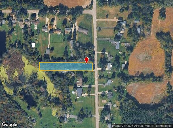
This Property Is For Sale
NEARBY LISTINGS FOR SALE OR LEASE
-
-
View all Flint listings for sale on LoopNet.com
Property Detail
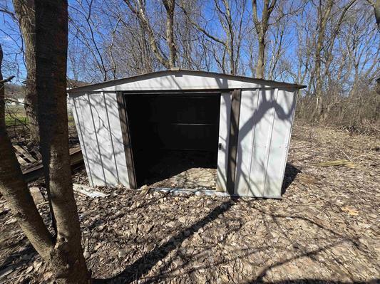
5203 N Vassar Rd
Flint, MI
Genesee
11-24-400-018
Michigan
Sfr
1.05 AC
X
Flint
26049C0204D
Detroit
971 SF
DEMOGRAPHICS near 5203 N Vassar Rd
1 Mile
3 Mile
5 Mile
2024 Total Population
1,216
15,369
48,370
2029 Population
1,169
15,059
47,658
Pop Growth 2024-2029
(3.87%)
(2.02%)
(1.47%)
Average Age
43
42
41
2024 Total Households
484
5,996
19,735
HH Growth 2024-2029
(3.93%)
(2.23%)
(1.64%)
Median Household Inc
$70,219
$62,626
$54,160
Avg Household Size
2.50
2.50
2.40
2024 Avg HH Vehicles
2.00
2.00
2.00
Median Home Value
$167,129
$150,693
$146,941
Median Year Built
1969
1972
1967
Nearby Places
- Restaurants
- Banks
- Shops
- Fitness
- Groceries
PUBLIC TRANSPORTATION
COMMUTER RAIL
Flint Amtrak Station (Blue Water - Amtrak)
DRIVE
WALK
Distance
Flint Amtrak Station (Blue Water - Amtrak)
20 min
8.3 mi
AIRPORT
Bishop International
DRIVE
WALK
Distance
Bishop International
38 min
17.7 mi
Freight Ports
Port of Toledo
DRIVE
WALK
Distance
Port of Toledo
153 min
123.6 mi
Nearby Properties
Address
Land Use
TOTAL SIZE
Lot Size
Zoning
Address
Land Use
TOTAL SIZE
Lot Size
Zoning
34,652 SF
208.43 AC
SRA
Address
Land Use
TOTAL SIZE
Lot Size
Zoning
2,400 SF
81 AC
R-4 MANUF
Address
Land Use
TOTAL SIZE
Lot Size
Zoning
633 SF
69.20 AC
R-4 MANUF
Address
Land Use
TOTAL SIZE
Lot Size
Zoning
2,874 SF
71.02 AC
R-4 MANUF
Address
Land Use
TOTAL SIZE
Lot Size
Zoning
57.47 AC
R-4 MANUF
Address
Land Use
TOTAL SIZE
Lot Size
Zoning
2,560 SF
42 AC
R-4 MANUF
Address
Land Use
TOTAL SIZE
Lot Size
Zoning
1,538 SF
17.74 AC
C-2 HWY CO
Address
Land Use
TOTAL SIZE
Lot Size
Zoning
44,160 SF
4.47 AC
C-2 HWY CO
Address
Land Use
TOTAL SIZE
Lot Size
Zoning
55,040 SF
6.04 AC
C-2 HWY CO
Address
Land Use
TOTAL SIZE
Lot Size
Zoning
112.60 AC
SRA
Address
Land Use
TOTAL SIZE
Lot Size
Zoning
312.60 AC
SRM
Address
Land Use
TOTAL SIZE
Lot Size
Zoning
12,480 SF
2.06 AC
C-2 HWY CO
Address
Land Use
TOTAL SIZE
Lot Size
Zoning
10,875 SF
1.51 AC
C-2 HWY CO
Address
Land Use
TOTAL SIZE
Lot Size
Zoning
3,183 SF
2.41 AC
C-2 HWY CO
Address
Land Use
TOTAL SIZE
Lot Size
Zoning
52,322 SF
6.24 AC
I-1 LHGT I
Address
Land Use
TOTAL SIZE
Lot Size
Zoning
1,920 SF
155.77 AC
SRA
Address
Land Use
TOTAL SIZE
Lot Size
Zoning
9,230 SF
1.49 AC
C-2 HWY CO
Address
Land Use
TOTAL SIZE
Lot Size
Zoning
9,301 SF
2.41 AC
C-2 HWY CO
Address
Land Use
TOTAL SIZE
Lot Size
Zoning
2,354 SF
1.86 AC
C-2 HWY CO
Address
Land Use
TOTAL SIZE
Lot Size
Zoning
1,160 SF
6.20 AC
C-2 HWY CO
Address
Land Use
TOTAL SIZE
Lot Size
Zoning
3,410 SF
1.27 AC
C-2 HWY CO
Address
Land Use
TOTAL SIZE
Lot Size
Zoning
11,764 SF
4.20 AC
I
Address
Land Use
TOTAL SIZE
Lot Size
Zoning
9,251 SF
1.44 AC
C-2 HWY CO
Address
Land Use
TOTAL SIZE
Lot Size
Zoning
10,650 SF
1.96 AC
C-2 HWY CO
Address
Land Use
TOTAL SIZE
Lot Size
Zoning
1,907 SF
80 AC
SRA
Address
Land Use
TOTAL SIZE
Lot Size
Zoning
3,293 SF
1.30 AC
C-2 HWY CO
Address
Land Use
TOTAL SIZE
Lot Size
Zoning
6,088 SF
1.25 AC
SRA
Address
Land Use
TOTAL SIZE
Lot Size
Zoning
9,000 SF
2.40 AC
C-2 HWY CO
Address
Land Use
TOTAL SIZE
Lot Size
Zoning
2,400 SF
1 AC
CB
Address
Land Use
TOTAL SIZE
Lot Size
Zoning
12,122 SF
4.59 AC
C-2 HWY CO
The World's #1 Commercial Real Estate Marketplace
Connect with us
© 2025 CoStar Group
The information above has been obtained from sources believed reliable. While we do not doubt its accuracy we have not verified it and make no guarantee, warranty or representation about it. It is your responsibility to independently confirm its accuracy and completeness. Any projections, opinions, assumptions, or estimates used are for example only and do not represent the current or future performance of the property. The value of this transaction to you depends on tax and other factors which should be evaluated by your tax, financial, and legal advisors. You and your advisors should conduct a careful, independent investigation of the property to determine to your satisfaction the suitability of the property for your needs.