Property Record
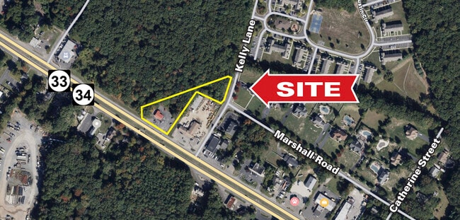
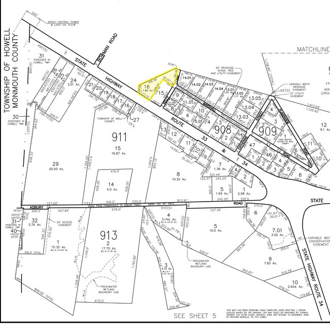
5204 State Route 33, Wall Township, NJ 07727

Save to a Folder
{{folder.Name}}
{{folder.ListingIds.length}} Properties
{{folder.ListingIds.length}} Property
Create a New Folder
Property Detail
5204 State Route 33
52-00907-0000-00016
ALSO LOT 34 NIT 1A
Storebuilding
Monmouth
HB40
New Jersey
B and X Area of moderate flood hazard, usually the area between the limits of the 100-year and 500-year floods.
16
2025
1.66 AC
2026
Southern Monmouth
808600
Northern New Jersey
1,047 SF
Lakewood-New Brunswick, NJ
NEARBY LISTINGS FOR SALE OR LEASE
-
-
-
-
No Photo
-
-
View all Wall Township listings for sale on LoopNet.com
DEMOGRAPHICS near 5204 State Route 33
1 mile
3 mile
5 mile
2025 Total Population
1,007
15,375
51,979
2030 Population
1,004
15,305
51,921
Pop Growth 2025-2030
(0.30%)
(0.46%)
(0.11%)
Average Age
40
46
45
2025 Total Households
361
6,685
20,657
HH Growth 2025-2030
(0.55%)
(1.23%)
(0.55%)
Median Household Inc
$102,778
$95,567
$118,127
Avg Household Size
2.80
2.20
2.40
2025 Avg HH Vehicles
2.00
2.00
2.00
Median Home Value
$686,305
$486,002
$583,775
Median Year Built
1990
1992
1987
Nearby Places
Map Layers
Map Styles
 Street
 Aerial
Layers
 Traffic
 Biking
Places
Listings with unknown addresses are not visible on the map
- Restaurants
- Banks
- Shops
- Fitness
- Groceries
PUBLIC TRANSPORTATION
COMMUTER RAIL
Asbury Park (North Jersey Coast Line - NJ Transit Commuter Rail (NJ Transit))
Drive
Walk
Distance
Asbury Park (North Jersey Coast Line - NJ Transit Commuter Rail (NJ Transit))
14 min
8.9 mi
Bradley Beach (North Jersey Coast Line - NJ Transit Commuter Rail (NJ Transit))
Drive
Walk
Distance
Bradley Beach (North Jersey Coast Line - NJ Transit Commuter Rail (NJ Transit))
13 min
9.0 mi
AIRPORT
Newark Liberty International
Drive
Walk
Distance
Newark Liberty International
59 min
48.0 mi
Freight Ports
New York Container Terminal
Drive
Walk
Distance
New York Container Terminal
52 min
40.1 mi
SALE & LEASE HISTORY
LISTING DATE
SALE/LEASE

Oct 06, 2023
For Sale
Aug 25, 2023
For Sale
Nearby Properties
Address
Land Use
TOTAL SIZE
Lot Size
Zoning
Address
Land Use
TOTAL SIZE
Lot Size
Zoning
434,405 SF
52.92 AC
RT66
Address
Land Use
TOTAL SIZE
Lot Size
Zoning
69,825 SF
94.37 AC
CCRC
Address
Land Use
TOTAL SIZE
Lot Size
Zoning
3,255.78 AC
ARE6
Address
Land Use
TOTAL SIZE
Lot Size
Zoning
134,075 SF
339.89 AC
OSGS
Address
Land Use
TOTAL SIZE
Lot Size
Zoning
37.47 AC
AH
Address
Land Use
TOTAL SIZE
Lot Size
Zoning
152,121 SF
22.16 AC
OR10
Address
Land Use
TOTAL SIZE
Lot Size
Zoning
25.37 AC
C-1
Address
Land Use
TOTAL SIZE
Lot Size
Zoning
3,040 SF
194.08 AC
OSGS
Address
Land Use
TOTAL SIZE
Lot Size
Zoning
181,064 SF
14.62 AC
IL
Address
Land Use
TOTAL SIZE
Lot Size
Zoning
8,100 SF
50.70 AC
IOP
Address
Land Use
TOTAL SIZE
Lot Size
Zoning
183,932 SF
23.51 AC
IL
Address
Land Use
TOTAL SIZE
Lot Size
Zoning
13 AC
SF40
Address
Land Use
TOTAL SIZE
Lot Size
Zoning
25,536 SF
21.95 AC
OR10
Address
Land Use
TOTAL SIZE
Lot Size
Zoning
28,819 SF
13.59 AC
ES
Address
Land Use
TOTAL SIZE
Lot Size
Zoning
912 SF
201.36 AC
RRC
Address
Land Use
TOTAL SIZE
Lot Size
Zoning
117,915 SF
17.32 AC
C-1
Address
Land Use
TOTAL SIZE
Lot Size
Zoning
46.34 AC
AH7
Address
Land Use
TOTAL SIZE
Lot Size
Zoning
103.42 AC
OSGS
Address
Land Use
TOTAL SIZE
Lot Size
Zoning
99.06 AC
MFG
Address
Land Use
TOTAL SIZE
Lot Size
Zoning
427.37 AC
POS
Address
Land Use
TOTAL SIZE
Lot Size
Zoning
3,400 SF
262.97 AC
AI
Address
Land Use
TOTAL SIZE
Lot Size
Zoning
108,661 SF
11.29 AC
R-4
Address
Land Use
TOTAL SIZE
Lot Size
Zoning
332,213 SF
26.55 AC
OR10
Address
Land Use
TOTAL SIZE
Lot Size
Zoning
647.36 AC
HD03
Address
Land Use
TOTAL SIZE
Lot Size
Zoning
71,660 SF
4.45 AC
C-1
Address
Land Use
TOTAL SIZE
Lot Size
Zoning
7,350 SF
161.08 AC
MFG
Address
Land Use
TOTAL SIZE
Lot Size
Zoning
379 AC
SF80
Address
Land Use
TOTAL SIZE
Lot Size
Zoning
76,289 SF
3.44 AC
R20
Address
Land Use
TOTAL SIZE
Lot Size
Zoning
3.61 AC
MF08
Address
Land Use
TOTAL SIZE
Lot Size
Zoning
12.74 AC
CCRC
The World's #1 Commercial Real Estate Marketplace
Connect with us
© 2026 CoStar Group
The information above has been obtained from sources believed reliable. While we do not doubt its accuracy we have not verified it and make no guarantee, warranty or representation about it. It is your responsibility to independently confirm its accuracy and completeness. Any projections, opinions, assumptions, or estimates used are for example only and do not represent the current or future performance of the property. The value of this transaction to you depends on tax and other factors which should be evaluated by your tax, financial, and legal advisors. You and your advisors should conduct a careful, independent investigation of the property to determine to your satisfaction the suitability of the property for your needs.