Property Record
5205 S Fm 549, Rockwall, TX 75032


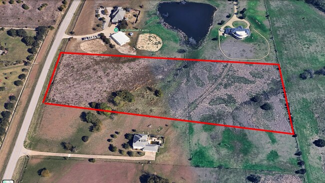
Property Detail
5205 S Fm 549
51335
ABS A0080, W W FORD, TRACT 17-14, 7.493 ACRES
Pasture
Rockwall
B and X Area of moderate flood hazard, usually the area between the limits of the 100-year and 500-year floods.
Texas
2025
7.49 AC
2025
Rockwall
040508
Dallas/Ft Worth
5,308 SF
Dallas-Fort Worth-Arlington, TX
NEARBY LISTINGS FOR SALE OR LEASE
DEMOGRAPHICS near 5205 S Fm 549
1 mile
3 mile
5 mile
2025 Total Population
1,887
30,024
69,532
2030 Population
2,274
35,819
83,445
Pop Growth 2025-2030
+ 20.51%
+ 19.30%
+ 20.01%
Average Age
37
38
39
2025 Total Households
571
10,245
24,433
HH Growth 2025-2030
+ 20.49%
+ 19.23%
+ 19.86%
Median Household Inc
$100,735
$104,752
$107,146
Avg Household Size
3.10
2.90
2.80
2025 Avg HH Vehicles
3.00
3.00
2.00
Median Home Value
$558,486
$450,953
$437,557
Median Year Built
2006
2006
2006
Nearby Places
Map Layers
Map Styles
 Street
 Aerial
Layers
 Traffic
 Biking
Places
Listings with unknown addresses are not visible on the map
- Restaurants
- Banks
- Shops
- Fitness
- Groceries
PUBLIC TRANSPORTATION
AIRPORT
Dallas Love Field
Drive
Walk
Distance
Dallas Love Field
45 min
30.5 mi
Freight Ports
Port of Shreveport
Drive
Walk
Distance
Port of Shreveport
199 min
181.0 mi
SALE & LEASE HISTORY
LISTING DATE
SALE/LEASE

Aug 20, 2019
For Sale
Aug 18, 2025
For Sale
Nearby Properties
Address
Land Use
TOTAL SIZE
Lot Size
Zoning
Address
Land Use
TOTAL SIZE
Lot Size
Zoning
326,761 SF
23.09 AC
Address
Land Use
TOTAL SIZE
Lot Size
Zoning
193,393 SF
80 AC
Address
Land Use
TOTAL SIZE
Lot Size
Zoning
44,191 SF
32.66 AC
Address
Land Use
TOTAL SIZE
Lot Size
Zoning
326,842 SF
21.28 AC
Address
Land Use
TOTAL SIZE
Lot Size
Zoning
311,294 SF
21.28 AC
Address
Land Use
TOTAL SIZE
Lot Size
Zoning
238,085 SF
34.49 AC
Address
Land Use
TOTAL SIZE
Lot Size
Zoning
413,908 SF
35.30 AC
Address
Land Use
TOTAL SIZE
Lot Size
Zoning
656,340 SF
34.23 AC
Address
Land Use
TOTAL SIZE
Lot Size
Zoning
157,834 SF
30.89 AC
Address
Land Use
TOTAL SIZE
Lot Size
Zoning
214,166 SF
21.42 AC
Address
Land Use
TOTAL SIZE
Lot Size
Zoning
198,270 SF
21.48 AC
Address
Land Use
TOTAL SIZE
Lot Size
Zoning
250,627 SF
18.17 AC
Address
Land Use
TOTAL SIZE
Lot Size
Zoning
153,541 SF
27.44 AC
Address
Land Use
TOTAL SIZE
Lot Size
Zoning
77,891 SF
11.61 AC
A
Address
Land Use
TOTAL SIZE
Lot Size
Zoning
391,599 SF
30.04 AC
Address
Land Use
TOTAL SIZE
Lot Size
Zoning
242,845 SF
16.01 AC
Address
Land Use
TOTAL SIZE
Lot Size
Zoning
226,384 SF
36.03 AC
Address
Land Use
TOTAL SIZE
Lot Size
Zoning
85,912 SF
5.93 AC
Address
Land Use
TOTAL SIZE
Lot Size
Zoning
174,826 SF
11.13 AC
Address
Land Use
TOTAL SIZE
Lot Size
Zoning
99,800 SF
10.10 AC
C
Address
Land Use
TOTAL SIZE
Lot Size
Zoning
288,266 SF
38.93 AC
Address
Land Use
TOTAL SIZE
Lot Size
Zoning
121,766 SF
4.28 AC
Address
Land Use
TOTAL SIZE
Lot Size
Zoning
227,610 SF
11.15 AC
Address
Land Use
TOTAL SIZE
Lot Size
Zoning
152,094 SF
20.29 AC
Address
Land Use
TOTAL SIZE
Lot Size
Zoning
57,666 SF
1.31 AC
Address
Land Use
TOTAL SIZE
Lot Size
Zoning
42,023 SF
4.19 AC
Address
Land Use
TOTAL SIZE
Lot Size
Zoning
57,303 SF
7.68 AC
Address
Land Use
TOTAL SIZE
Lot Size
Zoning
93,932 SF
10 AC
Address
Land Use
TOTAL SIZE
Lot Size
Zoning
202,607 SF
25.93 AC
Address
Land Use
TOTAL SIZE
Lot Size
Zoning
44,908 SF
1.03 AC
The World's #1 Commercial Real Estate Marketplace
Connect with us
© 2026 CoStar Group
The information above has been obtained from sources believed reliable. While we do not doubt its accuracy we have not verified it and make no guarantee, warranty or representation about it. It is your responsibility to independently confirm its accuracy and completeness. Any projections, opinions, assumptions, or estimates used are for example only and do not represent the current or future performance of the property. The value of this transaction to you depends on tax and other factors which should be evaluated by your tax, financial, and legal advisors. You and your advisors should conduct a careful, independent investigation of the property to determine to your satisfaction the suitability of the property for your needs.